HANLON NO.2
MEADOWS ROAD ROKEWOOD, GOLDEN PLAINS SHIRE
-
Add to tour
You must log in to do that.
-
Share
-
Shortlist place
You must log in to do that.
- Download report
Statement of Significance
This record has minimal details. Please look to the right-hand-side bar for any further details about this record.
-
-
HANLON NO.2 - History
Contextual History:History of Place:
Heritage Inventory History of Site:
HANLON No. 2 Shaft,
21.06.1901: mine is opening up in an excellent manner and the gold returns of the last few weeks place beyond doubt that there is gold in this mine.
28.06.1901: continues to obtain good gold and it is rumoured that the mine will be let on tribute.
02.08.1901: tribute party to sink in the north-east of this claim.
20.09.1901: this mine is not looking too bright.
1897 to 12.1903: recorded production of 18,681 ozs 10 dwt (or 577.963 kg). operated with a steam plant and puddler; the shaft at this mine was twisted by the drift as it was being sunk; a long drive north failed to find the lead, the English capital funding this mine ran out and the mine was let on tribute; the tibuters drove west and found gold on the west side of the creek; however the tribute lapsed and the company was unable to raise more money and the mine closed.Heritage Inventory Description
HANLON NO.2 - Heritage Inventory Description
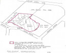
At Hanlon No.2 the majority of the material has been removed reducing the mullock heap to a "mesa" 20m in diameter and 5m high. On the southern side the heap has been extended to enclose a small powder magazine. The magazine, 1.2 by 1.2 by 1.2 metres is constructed of timber with a corrugated iron cladding on the outside with a slab of concrete 0.05m thick on the roof. The structure is lined and the space between the lining and the roof is insulated with sawdust. The mullock heap at the central is 20m in diameter and 4.5m high, and appears to be relatively intact. There is a circular concrete slab, 2.5m in diameter, on the south east corner at the base of the heap. The depression where the shaft was is 3m further south east. A rough stone structure set with cement mortar is located 28m east of the shaft depression. The walls of this structure are collapsing and do not seem strong enough to support any machinery. A badly corroded ore truck is lying on the east side of the mullock heap. At the United mine site there are two mullock heaps running north, 20m by 4m by 1.5m high, and north east, 50m by 10m by 2.5m, from where the shaft would have been. The first 12m has been removed from the heap that runs north east. There are a couple of small mounds west of the mullock heaps.
Heritage Inventory Significance: Not relevant
-
-
-
-
-
CARR & STANBROOK
 Victorian Heritage Inventory
 -
SCOTT AND PARTY
 Victorian Heritage Inventory
 -
ROKEWOOD CENTRAL CO.
 Victorian Heritage Inventory
-
-


