Pilots' Row Precinct
St. Andrews Street and King Street and Hesse Street QUEENSCLIFF, QUEENSCLIFFE BOROUGH

-
Add to tour
You must log in to do that.
-
Share
-
Shortlist place
You must log in to do that.
- Download report


Statement of Significance
The area is of significance as the centre of the development of community facilities and service groups including the Pilots Service, the Military and the lighthouses. These facilities and groups were the reason for the town's existence initially and over a long period provided work and occupations for its residents. While not as obviously cohesive at a visual level as other precincts the area is a strong social and historic base linking the physical elements. Essentially the area is considered to be of significance for these and the following reasons:
(j) the historic association of many of the buildings and structures with the social development of the town and with individual residents.
(ii) the impact of the Fort as a key element of the townscape
(iii) the relationship of the Fort to the Pilots' Rowand their associated operations
(iv) the architectural significance of the most important government buildings in the town and the oldest still standing
(v) the position of the Fort at the end of King Street, the main road into the town, and the sense of approach along Gellibrand Street
The Fort
The Fort is currently the subject of a major conservation study in its own right and the individual buildings within the complex are not included in detail in this study. The most important aspect of the Fort visually is the impact of the wall and keep, and the various buildings rising above them including the black lighthouse, the old telegraph station and lighthouse keepers' quarters and the signal tower. These buildings are an essential part of this precinct and their immediate visual surrounding should be preserved uninterrupted. In the case of 'all' buildings of historic and architectural interest within the Fort it is recommended that they should be conserved and a program far long term preservation be developed.
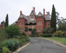
-
-
Pilots' Row Precinct - Usage/Former Usage
The Pilots' Reserve which encompassed all of Section II was substantially built upon by 1855, at which time nine weatherboard Pilots' cottages hod been erected and a house for the Port Phillip Health Officer on the Stokes Street corner. The Pilots' houses all faced onto Gellibrand Street and, as the Pilots moved elsewhere in the town, were gradually sold off or reserved for other purposes. At the south end of the reserve on the east side of Gellibrand Street the first Telegraph Station was erected in 1854-55 and in 1863 the upper lighthouse keepers' quarters were built to the south of this building. Both of these buildings are now contained within the fort complex as is the black lighthouse built in 1861-62.
Further to the south of these buildings the first military works took place with the construction of a seawall along the top of Shortlands Bluff in 1860 and the construction of the first battery in 1863. Military works have continued in the area until the present including the construction of the fort walls in 1882-83, enclosing the old telegraphic station and further extensive gun emplacement works.
The leading light to the south of the Fort was constructed in 1861-62 along with red brick lighthouse keepers' quarters replacing the earlier timber framed light which was dismantled and re-erected at Point Lonsdale. The original lighthouse keepers' quarters were demolished this century and replaced with a weatherboard structure.
Pilots' Row Precinct - Physical Description 1
Streetscape
This section of Gellibrand Street appears to be one of the few areas in Queenscliff which had trees planted along the street in the I860s. These trees were placed centrally, in front of and between each of the eight pilots' cottages. Each tree appears to have been protected by a small picket fence. The appearance of the roadway at that time was one of a winding dirt track with a footpath along the west side. The present appearance of the street to the east side is a gravel verge running onto the park with a central bitumen carriageway, and on the west side a concrete kerb and channel, footpaths and a grassed nature strip. There is clearly precedent here for more substantial street tree planting and it would benefit both sides of the street to establish an avenue of suitable street trees. The soft interface between the park and the road should be maintained on the east side and the remains of old concrete kerbing replaced with shallow open stone spoon drains.
Heritage Study and Grading
Queenscliffe - Queenscliffe Urban Conservation Study
Author: Allom Lovell & Associates P/L, Architects
Year: 1982
Grading:
-
-
-
-
-
LATHAMSTOWEVictorian Heritage Register H1052
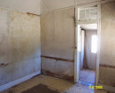
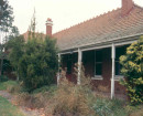
-
PILOTS COTTAGESVictorian Heritage Register H1618
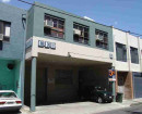
-
ROSENFELDVictorian Heritage Register H1134
-
-