CHURCH ROAD SITE
4022 WESTERN HIGHWAY TRAWALLA, PYRENEES SHIRE
-
Add to tour
You must log in to do that.
-
Share
-
Shortlist place
You must log in to do that.
- Download report
Statement of Significance
This record has minimal details. Please look to the right-hand-side bar for any further details about this record.
-
-
CHURCH ROAD SITE - History
The site lies in the centre of the Mount Emu Creek floodplain west of Trawalla, an area of gold mining activity during the first half of the 20th century. After the initial gold rushes of the 1850s, there followed further phases of mining activity in the 1880s; the period 1913-1918; and to a limited extent in the 1930s, during the depression (Nunan 1971, 11).
Most mining activity in the region occurred north-east of Beaufort, though there were also operations close to Trawalla (Nunan 1971, 11). Four alluvial mines dating from the first half of the 20th century are depicted on a map of mines in the vicinity of Mount Emu Creek: Unity, Trawalla Leads, Amazon and Southern Hope (Cayley and McDonald 1995, 97, fig . 53, Appendix 2). These are all located to the south of the Church Road site, the closest being the Amazon mine, a reef mining site operational from 1938 where there are two mine shafts and associated equipment (Cayley and McDonald 1995, 95). The mine was not particularly successful, and remained operational thanks to government support (Nunan 1971, 12). It is likely that the Church Road site is contemporary with, and perhaps associated with, the early 20th-century mines.
CHURCH ROAD SITE - Interpretation of Site
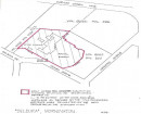
An aerial photograph taken in 1963 (906/6 Standard Mapsheet Photography, 7523S4, 906/6, no. 84) shows a standing structure, since demolished, at the location of the Church Road site, which is located in a small; irregular shaped subdivision of land. It is likely that the site was associated with the nearby mines, though whether it was a residence, public house or an industrial-related installation is unknown.
Test excavations in the vicinity of Church Road located glass and ceramic artefacts in seven test holes (fig. 3). Finds from the Church Road site include ceramic, bottle glass, fragments of iron and copper and cylinders of charcoal (figs. 8 and 9). The material appears to date from the first half of the 20th century, though the function of the site cannot be inferred from this small sample. The iron installation attached to wooden posts to the south of the site includes a length of piping on one side and a latch on the other (figs. 6 and 7). This feature has not been identified, though it is likely to be associated with the site's function, perhaps as a pulley. Therefore, it is possible that the site had a role in the processing of material obtained from the nearby gold mines.
CHURCH ROAD SITE - Archaeological Significance
The structure that once stood at the Church Road site has been demolished since the 1960s. During subsurface testing (undertaken as part of CHMP no. 11481), one test hole was found to contain loose earth with plentiful wood and some artefacts mixed in. On the basis of this excavation, the condition of the site appears to be poor. The excavated artefacts date from the first half of the 20th century, and include glass, ceramic and metal.
The site is deemed to have low archaeological significance in terms of its condition, though as its function has not been identified, its overall significance is hard to assess.
Heritage Inventory Description
CHURCH ROAD SITE - Heritage Inventory Description
Opposite the junction of Church Road with the Western Highway, west of Trawalla, is a slightly elevated and bare patch of land. Artefacts are located on the surface and were found during test excavations in the vicinity. Iron features, perhaps part of a pulley system, are attached to wooden posts beside the highway. Aerial photographs from the 1960s show a structure which has since been demolished.
-
-
-
-
-
TRAWALLA SCHOOL
 Victorian Heritage Inventory
 -
AMAZON MINE
 Victorian Heritage Inventory
 -
KILBOGIE OUTSTATION
 Victorian Heritage Inventory
-
-
