Back to search results
FORMER ALBERT PARK TIP AND BARRACKS SITE
AUGHTIE DRIVE ALBERT PARK, PORT PHILLIP CITY
FORMER ALBERT PARK TIP AND BARRACKS SITE
AUGHTIE DRIVE ALBERT PARK, PORT PHILLIP CITY
All information on this page is maintained by Heritage Victoria.
Click below for their website and contact details.
Victorian Heritage Inventory
On this page:
Statement of Significance
What is significant?
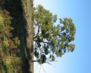
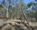
The dumping of rubbish, both from factories and households has been detailed in historical accounts from the late 1800s to the 1930s at Albert Park. These were carried out to bring try and deal with the increasing issues surrounding waste disposal in the city. From this, a number of trenches were cut to approximately two meters in depth to dispose of, burn and then cover this waste. The materials recovered in this tip give insight into daily life in Melbourne, patterns of waste disposal. The dumping of rubbish in Albert Park was also important in the overall process of raising the level of the park, filling in areas of swamp land, and ultimately, beautifying the area for public recreation.
How is it significant?
The site is of local historical significance, as well as archaeological significance. From excavation undertaken in this archaeological program, the extent and depth of these works have been determined, as well as a range of artefacts recovered to better understand the site. The site has significance in its ability to understand early waste management of Melbourne, what was disposed of, diet, as well as day-today life in a growing city during the late 1800s to early 1900s.
Why is it significant?
The Former Albert Park Barracks and Tips site is of historic significance to the broader understanding of waste management and day-to-day life in Melbourne from the late 1800s to early 1900s. It is representative of the range of waste deposited at the site in both household and industrial circumstances. Excavations on site have determined that the historical records of how the waste was disposed of and burnt, and how this was remediated, including the types of waste deposited are all correct. The site is significant in its ability to further understand life in Melbourne during this period of growth.
What is significant?
How is it significant?
Why is it significant?
What is significant?
How is it significant?
Why is it significant?
What is significant?
How is it significant?
Why is it significant?
What is significant?
How is it significant?
Why is it significant?
What is significant?
How is it significant?
Why is it significant?
What is significant?
How is it significant?
Why is it significant?
What is significant?
How is it significant?
Why is it significant?
What is significant?
How is it significant?
Why is it significant?
What is significant?
How is it significant?
Why is it significant?
What is significant?
How is it significant?
Why is it significant?
What is significant?
How is it significant?
Why is it significant?
Show more
Show less