Back to search results
UPFIELD RAILWAY INFRASTRUCTURE: BRUNSWICK TO COBURG
HOPE STREET, BRUNSWICK, 3056; HOPE STREET ROAD RESERVE; ORIENT GROVE, BRUNSWICK, 3056; 218 ALBION STREET, BRUNSWICK 3056; ALBION STREET, BRUNSWICK 3056; ALBION STREET RESERVE; 204 MORELAND ROAD BRUNSWICK, 3056; 2A STATION STREET, COBURG 3058; MORELAND R,
All information on this page is maintained by Heritage Victoria.
Click below for their website and contact details.
Victorian Heritage Inventory
On this page:
Statement of Significance
What is significant?
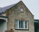
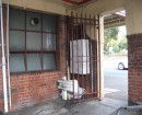
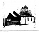
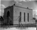
The collective representation and significance of this infrastructure along the rail corridor should be considered. These features represent arrange of activities associated with the Upfield railway line, including daily operation function to allow the transportation of goods and people, industrial usage, the operation of the rail system in an urban environment, and the permanent residential aspect associated with gatekeepers and station masters houses. The site is of historical importance for its association with the operation of the former Coburg Railway Line (H0952). This railway line was introduced in the early1880s and the associated infrastructure, including gatekeepers houses,gatekeepers cabins, hand-gates, rail sidings and other features represent components representative of its use in the transportation of goods and people. The site is of archaeological significance for their potential to provide evidence of the operation of the railway line,including insights into the daily operations and of workers associated with its operation. The site addresses the following category inVictoria?s Framework of Historical Themes: Connecting Victorians by transport and communications. ? Theme 3: Connecting Victorians by transport and communications (Sub-theme 3.3 Linking Victorians by rail -Associated Objects)
How is it significant?
The collective representation and significance of this infrastructure along the rail corridor should be considered. These features represent arrange of activities associated with the Upfield railway line, including daily operation function to allow the transportation of goods and people, industrial usage, the operation of the rail system in an urban environment, and the permanent residential aspect associated with gatekeepers and station masters houses. The site is of historical importance for its association with the operation of the former Coburg Railway Line (H0952). This railway line was introduced in the early1880s and the associated infrastructure, including gatekeepers houses,gatekeepers cabins, hand-gates, rail sidings and other features represent components representative of its use in the transportation of goods and people. The site is of archaeological significance for their potential to provide evidence of the operation of the railway line,including insights into the daily operations and of workers associated with its operation. The site addresses the following category inVictoria?s Framework of Historical Themes: Connecting Victorians by transport and communications. ? Theme 3: Connecting Victorians by transport and communications (Sub-theme 3.3 Linking Victorians by rail -Associated Objects)
Why is it significant?
The collective representation and significance of this infrastructure along the rail corridor should be considered. These features represent arrange of activities associated with the Upfield railway line, including daily operation function to allow the transportation of goods and people, industrial usage, the operation of the rail system in an urban environment, and the permanent residential aspect associated with gatekeepers and station masters houses. The site is of historical importance for its association with the operation of the former Coburg Railway Line (H0952). This railway line was introduced in the early1880s and the associated infrastructure, including gatekeepers houses,gatekeepers cabins, hand-gates, rail sidings and other features represent components representative of its use in the transportation of goods and people. The site is of archaeological significance for their potential to provide evidence of the operation of the railway line,including insights into the daily operations and of workers associated with its operation. The site addresses the following category in Victoria's Framework of Historical Themes: Connecting Victorians by transport and communications. ? Theme 3: Connecting Victorians by transport and communications (Sub-theme 3.3 Linking Victorians by rail -Associated Objects)
Show more
Show less