BAKERY HILL SAWN TIMBER WATER SUPPLY PIPE
PEEL STREET BAKERY HILL, BALLARAT CITY
-
Add to tour
You must log in to do that.
-
Share
-
Shortlist place
You must log in to do that.
- Download report
Statement of Significance
The Bakery Hill Sawn Timber Water Supply Pipe is of scientific significance due to its unusual construction. The enclosed timber construction of the box pipe demonstrates a functional design for the movement of water using a construction method which is no longer practiced. The site has the potential to provide evidence of construction techniques prior to the evolution of concrete water supply construction and the supply and movement of water across the Ballarat.
-
-
BAKERY HILL SAWN TIMBER WATER SUPPLY PIPE - History
The Yarrowee River to the west of the Bakery Hill Sawn Timber Water Supply Pipe was an area of focused activity within Ballarat, heavily modified by early settlement and gold mining. A gold digger’s recollection of Ballarat in 1852 notes the following about occupation along the Yarrowee River:
‘Ballarat was also a mere collection of tents, and a few slightly more substantial dwellings, and all was on the eastern side of the Yarrowee, save a few diggers’ tents to the west and the Camp group on the edge of the table land’ (Withers 1887).
As well as water for gold mining, the Yarrowee River provided people with drinking water and bathing water. In 1851 the natural course of the Yarrowee River was altered as a result of the demand for water when a channel was cut for the river to facilitate more water in the pools on the river flats (Victorian Heritage Database n.d.).
Early accounts of the environmental effects that gold mining had in Ballarat is reflected in an 1887 description by journalist W.B. Withers of the clear Yarrowee River water becoming polluted as gold mining activities took place along the riverbanks:
‘The quiet Ballarat sheep-run, with its grassy slopes and shadowy glades, and its green-galley where the Yarrowee poured its limpid waters, became suddenly transformed as by the wand of an enchanter. The Black Hill then looked upon the valley with a densely timbered head and face; whence its name was taken. The valley was thinly sprinkled with trees, and the ranges, with the spurs subsequently known as Golden Point, Bakery, Specimen and Sinclair’s Hills, were well-timbered, while the western basaltic table land, where Western Ballarat is now, was moderately sprinkled with the usual variety of forest growth. In a brief time, all this changed. Soon the solitary blue columns of smoke that rose from the first prospecting parties’ camping places were but indistinguishable items amidst a host. The one or two white tents of the prospectors were soon lost in crowded irregular lines and groups of tents that dotted the slopes and flats or spread out along the tortuous tracks made by the bullock teams of the squatter. The axe of the digger quickly made inroads upon the forest all round; the green banks of the Yarrowee were lined with tubs and cradles; its clear waters were changed to liquid, yellow as the yellowest Tiber flood, and its banks grew to be long shoals of tailings. Everywhere little hillocks of red, yellow and white earth were visible as the diggers got to work, and in a few weeks the green slopes, where the prospectors found the gold of Golden Point, changed from their aboriginal condition to the appearance of a fresh and rudely made burial ground. At first the upturned colored earth-heaps were but as isolated pustules upon the fair face of the primeval hills and valley, but they rapidly multiplied until the ran together, so to speak, and made the forest swards but so many blotched reaches of industrious disorder, the very feculence of golden fever everywhere in colored splotches with shadowed pits between’ (Withers 1887).
After the initial rush on surface alluvial gold in Ballarat in 1851, precious metal recovery required a considerable investment in time, capital, and engineering to reach to the deeper lead gold. The resultant developments in technology would make Ballarat a centre for engineering and industrial manufacture (Bate 1999). An extensive network of bluestone and brick channels and culverts were built within the residential and commercial areas. This infrastructure was also used to drain stormwater and liquid wastes such as industrial wastes, sanitary wastes and sludge (Hansen Partnership Pty Ltd et al. 2003: 18; Victorian Places 2015).
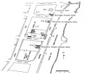
While no specific information pertaining to the timber structure is available, mid-nineteenth century maps of Ballarat indicate that it is situated near washpools and workings associated with gold mining in the area (Figure 1).BAKERY HILL SAWN TIMBER WATER SUPPLY PIPE - Interpretation of Site
Water supply and waste disposal for gold diggings at Ballarat during the nineteenth century consisted of an array of water races, flumes and pipes, each feeding a reservoir or puddling operation (Lawrence & Davies 2019, Zweep 2006). The majority of supply pipes or flumes would have been of open construction. The sawn timber box supply pipe likely forms part of the drainage infrastructure associated with the movement of water to and/or from the nearby Yarrowee Creek Channel. The sawn timber box water supply pipe appears to have been originally situated on natural ground, possibly overlapping another water race (see Attachment A: Figures 1 -3). The fully enclosed structure of the pipeline is rare for water management across gold diggings due to the expense of sawn timbers at the time and may have been undertaken to ensure the security of water supply across the diggings (Zweep 2006). It is therefore unlikely that the Bakery Hill Sawn Timber Water Supply Pipe would have been utilised for the removal of sludge during gold workings, and was rather a supply pipe for fresh water, possibly from the Yarrowee Creek Channel. Over time the timber supply pipe was covered in either clay or sludge from nearby gold diggings. A roadway and concrete footpaths were constructed over the supply pipe during the twentieth century (see Attachment B: Extent Map).
Heritage Inventory Description
BAKERY HILL SAWN TIMBER WATER SUPPLY PIPE - Heritage Inventory Description
The Bakery Hill Sawn Timber Water Supply Pipe consists of an enclosed square 420mm x 420mm sawn timber box water supply pipe located 1.25m beneath the road surface at the northern extent of the junction between Eastwood Street and Peel Street, Bakery Hill. The known (unearthed) extent of the structure runs east-west along Eastwood Street and measures approximately 5m in length, however it is unknown how far the site extends either east or west outside of the area exposed during works. The sawn timber box supply pipe likely forms part of the drainage infrastructure associated with the movement of water to and/or from the nearby Yarrowee Creek Channel. The site appears to be intact and well-preserved, without visible evidence of modification. The site was identified during works for sewer duplication in East Ballarat on 24 August 2021. The unexpected find was reburied, and its discovery subsequently reported to Heritage Victoria.
-
-
-
-
-
SWAN HILL WATER TOWER
 Victorian Heritage Register H2452
 -
RULES OF THE MELBOURNE FOOTBALL CLUB
 Victorian Heritage Register H2428
 -
MOUNT LITTLE DICK FIRE TOWER
 Victorian Heritage Register H2461
-
-


