Back to search results
MOUNT MISERY DIGGINGS CHINESE CAMP SITE
JUNCTION OF BERRINGA-MISERY CREEK ROAD AND MISERY CREEK ROAD ENFIELD, GOLDEN PLAINS SHIRE
MOUNT MISERY DIGGINGS CHINESE CAMP SITE
JUNCTION OF BERRINGA-MISERY CREEK ROAD AND MISERY CREEK ROAD ENFIELD, GOLDEN PLAINS SHIRE
All information on this page is maintained by Heritage Victoria.
Click below for their website and contact details.
Victorian Heritage Inventory
On this page:
Statement of Significance
What is significant?
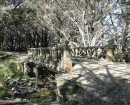
Archaeological elements include terraces, fireplaces, remnant market gardens and other typical settlement features. This place contains a shop, possible pig oven and rectangular tank, as well as pits and water races. The Mt Misery Chinese Diggings have remained relatively undisturbed.
The Mt Misery Creek Chinese Camp is of historical significance as an example of a relatively intact Chinese camp in the region with occupation ranging from the initial discovery of gold until the twentieth century. The camp is of social and archaeological importance to its potential to reveal information about the daily lives of Chinese miners and other information relating to these communities.
The Mt Misery Creek Chinese Camp is of historical significance as an example of a relatively intact Chinese camp in the region with occupation ranging from the initial discovery of gold until the twentieth century. The camp is of social and archaeological importance to its potential to reveal information about the daily lives of Chinese miners and other information relating to these communities.
How is it significant?
Why is it significant?
Show more
Show less
-
-
-
-
RULES OF THE MELBOURNE FOOTBALL CLUB
 Victorian Heritage Register H2428
 -
NORTH MELBOURNE POTTERY
 Victorian Heritage Inventory
 -
STONY CREEK SLIPWAY
Victorian Heritage Inventory
-
..esterville
 Yarra City
 -
1 Alfred Crescent
Yarra City
-
1 Barkly Street
Yarra City
-
-