Back to search results
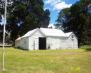
STATION STREET SHOP AND DWELLING
STATION STREET CARRUM - PROPERTY NUMBER 506-507, KINGSTON CITY
STATION STREET SHOP AND DWELLING
STATION STREET CARRUM - PROPERTY NUMBER 506-507, KINGSTON CITY
All information on this page is maintained by Heritage Victoria.
Click below for their website and contact details.
Victorian Heritage Inventory
On this page:
Statement of Significance
What is significant?
The extant historic shop and dwelling constructed c.1908 to 1914, and any additional archaeological features and deposits that may be preserved within the property boundaries (506-507 Station Street, Carrum) that are associated primarily with the historic ownership and occupation of the land.
How is it significant?
The site is of historical and archaeological significance at a local level.
Why is it significant?
The site is historically significant as it: Demonstrates key historic phases of Carrum’s history – the sub-division of the former Carrum swamp lands; the development of the township of Carrum; and establishment and operation of commercial business (grocery, butchers) during the early-twentieth century; and Is historically associated with a number of early residents of the Township of Carrum including members of the Rigby family and Walter Black.
The site has archaeological significance for its potential to contain historical archaeological features, deposits and artefacts associated with the use and occupation of the site as a commercial business (grocery and butcher) and domestic residence – primarily during the historic ownership and occupation of the land during the period c.1908 to c.1930.
Show more
Show less
-
-
-
-
RULES OF THE MELBOURNE FOOTBALL CLUB
 Victorian Heritage Register H2428
 -
MOUNT LITTLE DICK FIRE TOWER
Victorian Heritage Register H2461
-
NORTH MELBOURNE POTTERY
 Victorian Heritage Inventory
-
-