Back to search results
KERANG-QUAMBATOOK ROAD RUIN
2596 KERANG-QUAMBATOOK ROAD QUAMBATOOK, GANNAWARRA SHIRE
KERANG-QUAMBATOOK ROAD RUIN
2596 KERANG-QUAMBATOOK ROAD QUAMBATOOK, GANNAWARRA SHIRE
All information on this page is maintained by Heritage Victoria.
Click below for their website and contact details.
Victorian Heritage Inventory
On this page:
Statement of Significance
What is significant?
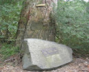
The Kerang-Quambatook Road Ruin represents an early farming homestead on the Mallee fringe. There remains a high potential for undisturbed archaeological deposits to remain in association with the freestanding mud brick ruins.
How is it significant?
The Kerang-Quambatook Road Ruin is of local historical and archaeological significance for its association with the spread of agricultural practices into the Mallee fringe.
Why is it significant?
The Kerang-Quambatook Road Ruin is of historical significance for representing the spread of agricultural activity into a new region – the Mallee fringe - at the turn of the 20th Century. The site also attests to the development and adaptation of European farming practices to a new, hostile environment.
The Kerang-Quambatook Road Ruin is of archaeological significance for the high likelihood of undisturbed archaeological deposits remaining at the site. A site inspection revealed that large numbers of surface artefacts dating to the abandonment of the residence in the mid 20th Century are present at the surface level, and it remains probable that additional archaeological material dating from the late 19th Century to early 20th Century exists in a surface and subsurface context at the site. Any archaological deposits are likely to shed light on the development and spread of agricultural activity, as well as everyday farming life on the Mallee fringe.
Show more
Show less
-
-
-
-
-
RULES OF THE MELBOURNE FOOTBALL CLUB
 Victorian Heritage Register H2428
 -
MOUNT LITTLE DICK FIRE TOWER
Victorian Heritage Register H2461
-
NORTH MELBOURNE POTTERY
 Victorian Heritage Inventory
-
-