Back to search results
MORDIALLOC HIGH SCHOOL CARETAKER’S COTTAGE
1 STATION STREET ASPENDALE, KINGSTON CITY
MORDIALLOC HIGH SCHOOL CARETAKER’S COTTAGE
1 STATION STREET ASPENDALE, KINGSTON CITY
All information on this page is maintained by Heritage Victoria.
Click below for their website and contact details.
Victorian Heritage Inventory
On this page:
Statement of Significance
What is significant?
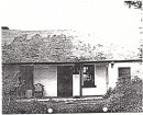
Archaeological features and deposits and /or artefacts associated with the former Caretaker's Cottage. While surface features associated with the historical fabric of the Caretaker’s Cottage have been removed, subsurface components exceeding 75 years old are potentially present below the ground surface. The site dates from c. 1928, and is shown on archival photographs from the 1930s until at least the late 1970s. The exact demolition date is uncertain, but the cottage and its outbuildings were removed by 2006, based on satellite imagery. Although the cottage was built of timber, there could be archaeological features and deposits associated with brick chimney and fireplaces, timber floor and wall stumps, postholes, a cesspit, refuse pits and possibly artefacts.
How is it significant?
The Mordialloc High School Caretaker’s Cottage is historically and archaeologically significant to the state of Victoria. The Caretaker’s Cottage was constructed in 1929 (Whitehead 2018b). Although there are numerous school sites from suburban Melbourne registered on the Victorian Heritage Register (VHR), such as H1641 MacRobertson Girls’ High School in Melbourne, H2183 University High School in Parkville, and H1636 Melbourne High School in South Yarra, school sites in general are not well-represented on the Victorian Heritage Inventory (VHI). Caretakers’ cottages have a similar representation on the state heritage lists, with numerous standing buildings associated with public institutions included on the VHR and National Trust lists. There are only a few caretakers’ cottages listed on the VHI, including H7922-0466 Maroondah Aqueduct former Caretakers Hut in the Yarra Ranges, and H7922-0490 Former Preston Reservoir Caretaker’s House Cellar in Reservoir. Neither of these sites are associated with schools. As such, the Mordialloc High School Caretaker’s Cottage is unique as there do not appear to be other such sites listed in the Victorian Heritage Database and inventory.
Why is it significant?
The Mordialloc High School Caretaker’s Cottage is associated with the construction of employee housing and the development of the education system in Mordialloc in the early 20th century. The site is over 75 years in age and has significance within the Mordialloc community, being an early residence associated with the development of the Mordialloc-Chelsea High School. This relates to the themes of Educating People (8.2) and Making homes for Victorians (6.7) as set out in Victoria’s Framework of Historical Themes.
Show more
Show less
-
-
-
-
-
SWAN HILL WATER TOWER
 Victorian Heritage Register H2452
 -
RULES OF THE MELBOURNE FOOTBALL CLUB
Victorian Heritage Register H2428
-
MOUNT LITTLE DICK FIRE TOWER
Victorian Heritage Register H2461
-
-