Back to search results
CLOVER DAM CONSTRUCTION CAMP SOUTH
BOGONG HIGH PLAINS ROAD BOGONG, ALPINE SHIRE
CLOVER DAM CONSTRUCTION CAMP SOUTH
BOGONG HIGH PLAINS ROAD BOGONG, ALPINE SHIRE
All information on this page is maintained by Heritage Victoria.
Click below for their website and contact details.

Victorian Heritage Inventory
-
Add to tour
You must log in to do that.
-
Share
-
Shortlist place
You must log in to do that.
- Download report
On this page:
Statement of Significance
What is significant?
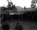
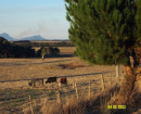
The Clover Dam Construction Camp South consists of the landscaped remnants of a workers camp constructed and used in the 1930s and 1940s. It is located adjacent to the Clover Power station on the Bogong High Plains Road.
How is it significant?
The Clover Dam Construction Camp South is of historical and scientific (archaeological) significance
Why is it significant?
The Clover Dam Construction Camp South is of historical significance as part of the largest Hydro Electricity Scheme to be constructed in Victoria. Together with Clover Dam Construction Camp North, they were home to hundreds of predominantly migrant workers, who, like the larger Snowy Mountains Scheme, found a new home in Australia and made a major contribution to Australia society.
The Kiewa Hydro-Electric Scheme, built from the 1930s to the 1960s, was the largest civil engineering project of its time in the State. The Kiewa Scheme provided massive employment, new townships and roads to the Shire, and enabled the development of Falls Creek ski field.
The Clover Dam Construction Camp South is of archaeological significance for its capacity to provide information (through archaeological investigation) of the lives of the construction workers, in a context that is currently poorly documented or understood. The relative isolation of the workers, their diverse origins, and their ability to adapt to an unfamiliar environment provide opportunities for important archaeological research. The same isolation and lack of local services also creates a rare context where material objects related to the occupation of the site are highly likely to remain in their original context, or very close to their place of use. As such the site has the potential to preserve a unique archaeological record.
Show more
Show less
-
-
CLOVER DAM CONSTRUCTION CAMP SOUTH - History
The historical land use of the study area is related to the construction of the Kiewa Hydro Scheme. This scheme dramatically changed the region with the construction of the Kiewa scheme for the generation of hydroelectric power, but also the towns, major roads and public infrastructure such as hospitals constructed for the workers and families (Lawrence 2008).The scheme was first proposed in 1911 (Lawrence 2008), however, construction of the scheme did not commence until 1937. It suffered delays and a reduction of the scope from the original plans due to a recession and resources being limited due to the Second World War (Kiewa catchment 2023).Work was resumed in the mid-late 1940s after the end of the Second World War, with large numbers of migrant workers taking advantage of employment opportunities offered by the scheme (Lawrence 2008). Large worker camps including Mt Beauty and Bogong Village were constructed during this time, as well as many smaller workers’ camps. At its peak, 4000 people were working on the scheme (Museum and History, 2022).The scheme was completed and commissioned in 1960, though the final system was smaller than what had originally been planned. The final version consisted of four power stations (Lawrence 2008), five aqueducts and five dams which are all still in operation today (Kiewa catchment 2023). The scheme was privatised in the 1990s and was acquired by Southern Hydro during this period. It was then purchased by AGL energy in 2005 who currently retains ownership (Museum and History 2022).Heritage Inventory Description
CLOVER DAM CONSTRUCTION CAMP SOUTH - Heritage Inventory Description
Clover Dam Construction Camp South comprises a terraced area between the Bogong High Plains Road and Kiewa River East Branch, formerly occupied by a series of timber buildings for construction workers' accommodation, workshops, offices and stores. The various terraced areas for building sites and tracks can be readily identified, with some areas of concrete slab and hard stand remaining. The operating Clover No 3 Power Station is located across the river on the east bank, connected by a concrete bridge, with a switching yard located on the west bank. Exotic trees and garden plants are evident, particularly near the river bank, which are believed to be remnant landscaping from when the camp was occupied. Fragments of timber, metal and glass are visible on the surface in several locations. Clover Dam Camp South consists of a benched area to the west of the Clover Dam Power Station. The benches approximately correlate with what can be seen on the 1940s photograph. There are two layers of benching between the Bogong High Plains Road and the power station, each approximately 1.5 metres high at the southern extent but converge to the same level at the access track to the north. The benches are overgrown with grass, obscuring the ground surface. There is no evidence of erosion or further modification. Concrete steps are present that lead from the lower benched area down to the level of the power plant.
-
-
-
-
-
RULES OF THE MELBOURNE FOOTBALL CLUBVictorian Heritage Register H2428
-
NORTH MELBOURNE POTTERYVictorian Heritage Inventory
-
STONY CREEK SLIPWAYVictorian Heritage Inventory
-
-