Back to search results
HAYTERS SHEEP DIP AND STOCK YARDS, CANNUM
HARDERS ROAD CANNUM, YARRIAMBIACK SHIRE
HAYTERS SHEEP DIP AND STOCK YARDS, CANNUM
HARDERS ROAD CANNUM, YARRIAMBIACK SHIRE
All information on this page is maintained by Heritage Victoria.
Click below for their website and contact details.
Victorian Heritage Inventory
On this page:
Statement of Significance
What is significant?
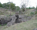
The visible remains of a nineteenth to early-twentieth century sheep dip (brick), adjacent timber platform (likely drying/dripping pen), remnant fence posts marking the location of the former stock yards, and any additional archaeological features, deposits and historic modifications to the landscape that relate to the occupation/function of the site as a sheep management facility (dip and shearing shed) during the period c.1877 to c.1939.
How is it significant?
The site is of historical and archaeological significance at a local level.
Why is it significant?
The site is historically significant as it is associated with the construction and subsequent operational use of the sheep dip, yard and farm (shearing) shed during the late-nineteenth to early twentieth century (c.1877 to 1939) during ownership/occupation of the land by the Hayter family. The historic farming property encompassing/associated with the site is of local heritage significance due to its association with George Hayter and his family, who occupied land selected under Section 20 of the Land Act 1869 during the 1870s and were amongst the earliest European settlers in the Cannum region. The establishment of farming properties under this Act had a significant impact on settlement patterns in the region.
The site has archaeological significance for its potential to contain historical archaeological features, deposits and artefacts associated with the construction and early occupation period (c.1877 to c.1939), including (but not necessarily limited to): the site’s currently identified primary features – a brick sheep dip, timber platform/floor (dripping/drying pen) – and stock yards; and an associated former shearing shed, which is likely contemporary with these features.
Show more
Show less
-
-
-
-
-
RULES OF THE MELBOURNE FOOTBALL CLUB
 Victorian Heritage Register H2428
 -
NORTH MELBOURNE POTTERY
 Victorian Heritage Inventory
 -
STONY CREEK SLIPWAY
Victorian Heritage Inventory
-
-