Grindlay's Estate Heritage Precinct
Brown Street and Collingwood Road (part) and Douglas Parade (part) and Elgin Street and Grindlay Street and Home Road (part) and Irving Street and North Road (part) and Rupert Street and Tait Street (part) NEWPORT, Hobsons Bay City
![Hobsons Bay City](http://api.heritagecouncil.vic.gov.au/img/owner_icons/7.gif)
-
Add to tour
You must log in to do that.
-
Share
-
Shortlist place
You must log in to do that.
- Download report
![Grindlay's Estate Heritage Precinct, Hobsons Bay Heritage Study 2006 Grindlay's Estate Heritage Precinct, Hobsons Bay Heritage Study 2006](https://vhd.heritagecouncil.vic.gov.au/vhd-images/places/000/016/530.jpg)
![Grindlay's Estate Heritage Precinct, Hobsons Bay Heritage Study 2006 Grindlay's Estate Heritage Precinct, Hobsons Bay Heritage Study 2006](https://vhd.heritagecouncil.vic.gov.au/vhd-images/places/000/016/531.jpg)
Statement of Significance
The Grindlay's Estate Heritage Precinct, which comprises all land in HO10 and is generally bounded by Douglas Parade, North Road, Grindlay Street, Tait Street and Collingwood Road, Newport . These streets form part of the Estate first laid out by Thomas Braim in 1888, in Newport.
How is it Significant?
The Grindlay's Estate Heritage Precinct is of local historic and aesthetic significance to the City of Hobsons Bay.
Why is it Significant?Historically, it is significant for the ability to illustrate the two key development phases of Newport. The Victorian houses and the subdivision layout represent the speculative residential estates created in the 1880s near railway lines, while the Edwardian and Interwar dwellings demonstrate the second phase of rapid residential growth that occurred during the early twentieth century following the development of local industries. It also has associations with the surveying firm of Bruford and Braim. (AHC criteria A4 and D2)
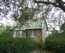
Aesthetically, it is significant as a relatively intact area of representative housing predominantly from the Edwardian and Interwar periods. It is notable for its consistent character, which is derived from the weatherboard single storey detached houses often with a front verandah or porch, garden or front setback, some side setback, hip or gable roof forms clad in Marseilles pattern terra-cotta tiled or corrugated iron and low timber framed front fences. (AHC criterion E1)
On this basis, the following properties and other elements contribute to the significance of the precinct:
- Brown Street (odd) 1-9 (even) 2-14
- Collingwood Road (odd only) 7, 9, 13, 17-35 and 39-51
- Douglas Parade (odd) 305-311 (Note: Places north of Collingwood Road are included in the Halls Farm Heritage Precinct)
- Grindlay Street (odd) 3 and 7 (even) 4, 6, 8 and 10
- Elgin Street (odd) 1-7 (even) 2-8
- Home Road (odd) 5-9 and 13-17 (even) 2 (Note: Places north of Collingwood Road and Tait Street are included in the Halls Farm Heritage Precinct (HO11))
- Irving Street (odd) 1-7
- North Road (even only)
ยง North Road (even only) 20-24, 28-34, 38, 40-44, 64-72, 76, 78, 86, 88, 92, 100 and 102.
- Rupert Street (odd) 1, 3 and 5 (even) 2, 4, 8
- Tait Street (odd) 1-15 (Note: Places north of Tait Street are included in the Halls Farm Heritage Precinct (HO11).
- Bluestone kerb and channel throughout the precinct
Please note that some heritage places within this precinct may also have an individual citation in this Study.
-
-
Grindlay's Estate Heritage Precinct - Physical Description 1
This precinct is formed around the 1888 Grindlay Estate boundaries and is generally bounded by Douglas Parade, North Road, Grindlay Street, Tait Street and Collingwood Road, Newport.
This precinct contains predominantly single storey weatherboard houses from the Edwardian (Federation bungalow) and interwar (Californian Bungalow) periods. There are also some Victorian-era houses, which are usually weatherboard and Italianate in style - a notable example is the double fronted brick Victorian Villa at 3 Rupert Street (q.v.). Typically, the houses are asymmetrical in plan and have a garden front setback, some side setback, complex pitched roof forms (hipped and/or gabled), Marseilles pattern terra-cotta tiled and corrugated iron clad roofs, with some original timber framed front fences to a maximum height of nominally 1.2m. Garages or provision for cars were not obvious in the area's early development.
Some notable houses, which are individually cited in this Study, include the above mentioned house at 3 Rupert Street as well as:
- The Edwardian row houses at 64-70 North Road.
- The postwar Moderne-influenced house at 88 North Road.
- The intact interwar house and unusual fence at 4 Grindlay Street.
Apart from the examples cited above, few of the houses have any individual architectural merit but are related in terms of their representation of historical themes, and possess similar scale, setbacks, form and detailing that create cohesive groups of distinctive character. The following specific comments are made for each street in the precinct.
Brown Street
Brown Street almost exclusively consists of inter-war weatherboard bungalows with consistent front and side setbacks. Few front fences are original, but most are low and many are related to the style of the house. The integrity is very high as there are few post-war dwellings.
Collingwood Road
Collingwood Road comprises predominantly Edwardian and inter-war weatherboard bungalows with some Victorian villas. Front and side setbacks are consistent. Few fences are original, but most are low and many are related to the style of the house. The integrity is relatively high as more than 75% of places are contributory. At the corner of Home Road is a substation constructed by Williamstown City Council. It is a simple brick building with a gabled roof - this was demolished circa 2007.
Douglas Parade
Douglas Parade south of Collingwood Road comprises a small group of Edwardian and inter-war weatherboard bungalows. Front and side setbacks are consistent. Few fences are original, but most are low and many are related to the style of the house. The integrity is high with 80% of dwellings listed as contributory.
Elgin Street comprises predominantly interwar weatherboard bungalows. Front and side setbacks are consistent. Few fences are original, but most are low and many are related to the style of the house. The integrity is high and cohesion is good as there are few non-contributory places.
Grindlay Street
Grindlay Street is a mixture of interwar and post-war houses. Consequently, the integrity of the street ismoderate when compared to other streets within the precinct. There is, however, one notable exception at No. 4, which is an intact inter-war bungalow with a carport and an original front fence of unique design (Refer to the individual citation in this Study)
Home Road
Home Road south of Collingwood Road and Tait Street comprises predominantly Edwardian and interwar weatherboard bungalows. Front and side setbacks are consistent. Few fences are original, but most are low and many are related to the style of the house. The integrity is moderate as almost 40% are non-contributory.
Irving Street
The west side of Irving Street comprises a group of related inter-war weatherboard bungalows. Front and side setbacks are consistent. Few fences are original, but most are low and many are related to the style of the house. The integrity is high along the western side of the street with all dwellings contributory however the integrity is low along the eastern side of the street.
North Road
The north side of North Road comprises a mixture of Victorian villas, and Edwardian and inter-war weatherboard bungalows. Front and side setbacks are generally consistent. Few fences are original, but most are low and some are related to the style of the house. The integrity is relatively low compared to other streets in the precinct as more than 50% of dwellings are non-contributory and there has been some intrusive recent development. However there are some notable individual places such as the Edwardian terrace row at Nos. 64-70 and the postwar Moderne house at No. 88, as well as cohesive groups of related places.
Rupert Street
Rupert Street includes one notable Victorian Italianate brick villa at No. 3 (q.v.) and otherwise predominantly comprises inter-war weatherboard bungalows. Front and side setbacks are consistent. Few fences are original, but most are low and many are related to the style of the house. The integrity is relatively high as more than 75% are contributory.
Tait Street
Tait Street comprises predominantly Edwardian and inter-war weatherboard bungalows with some brick dwellings. Front and side setbacks are consistent. Few fences are original, but most are low and many are related to the style of the house. The integrity is moderate to high as there are few post-war dwellings that are mostly at the western end of the street.
Grindlay's Estate Heritage Precinct - Integrity
Integrity
Moderate. See above for specific comments for each StreetGrindlay's Estate Heritage Precinct - Usage/Former Usage
Context
Set between the railway and the coast on a flat site, with associated railway station as the focus of the initial settlement pattern and commercial areas along Melbourne Road, Hall Street and Mason Street.Grindlay's Estate Heritage Precinct - Historical Australian Themes
Principal Australian Historical Theme(s)
Making Suburbs
Grindlay's Estate Heritage Precinct - Physical Description 2
Associations
Thomas Braim
Heritage Study and Grading
Hobsons Bay - Hobsons Bay Heritage Study
Author: Hobsons Bay City Council
Year: 2006
Grading:
-
-
-
'Lawn House' (Former)Hobsons Bay City
-
1 Fairchild StreetYarra City
-
10 Richardson StreetYarra City
-
-