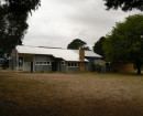
Seddon Residential & Commercial Area
Albert, Barnet, Bayview, Bellairs, Berry, Browning, Burnes, Chapman, Charles, Dane, Fairlie, Fielding, Gamon, Grace, Greig, and Hamilton, Harriet, Hobbs, Hood, Hotham, Lawrence, Little Berry, Little Smith, Mackay, Melbourne, Montague, Nicholson, O'Farrell
 - Seddon Residential and Commercial Area.JPG")
 - Seddon Residential and Commercial Area.JPG")
 - Seddon Residential and Commercial Area.JPG")
 - Seddon Residential and Commercial Area.JPG")
 - Seddon Residential and Commercial Area.JPG")
Statement of Significance
Statement of Significance
The Seddon Residential & Commercial Precinct is significant to the Western Region of Melbourne because:
- it is one of the best preserved of the city's Edwardian residential enclaves and thus is expressive of this major growth era in the City's history and the parallel development of better railway facilities as expressed by:
- small Edwardian and Victorian period single-storey detached and some attached housing, with a dominance of weatherboard walling and corrugated iron roofing,
- gable and hip roof form combination inherent in Edwardian housing,
- some surviving early asphalt footpaths and stone kerb and channel, and
- originally no provision for on-site vehicle parking for most of the identified housing, as an expression of the pre motor-age and dependence on railway transport, and
- related strip commercial development aligned along the major transport routes such as the railway and Williamstown Road, the latter development group with zero lot lines, parapeted one and sometimes two storey masonry construction (Criterion A4);
- it contains both residential and commercial development clustered around the railway line and station and thus is evocative of residential patterns related to transport options (Criterion A3, A4); and
- of the irregular street patterns created mainly in the 19th century are evocative of the failure of the 1880s boom period as well as the role of the small speculator in shaping the City (Criterion A4).
Australian Heritage Commission (AHC) criteria
The Australian Heritage Commission criteria consist of a set of eight criteria which cover social, aesthetic, scientific, and historic values. Each criterion has sub-criteria written specifically for cultural or natural values. The relevant criteria are:
A.3 richness and diversity of cultural features
A.4 demonstrates well the course and pattern of history, important historic events
-
-
-
-
-
SUN THEATRE
 Victorian Heritage Register H0679
 -
STATE SAVINGS BANK
Victorian Heritage Register H0723
-
YARRAVILLE RAILWAY STATION COMPLEX
Victorian Heritage Register H2447
-
'ELAINE'
 Boroondara City
 -
-oonah
 Yarra City
 -
..eld House
Yarra City
-
-