Corindhap Precinct
Colac-Ballarat Rd Corindhap, Golden Plains Shire

-
Add to tour
You must log in to do that.
-
Share
-
Shortlist place
You must log in to do that.
- Download report


Statement of Significance
What is Significant?
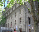
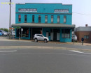
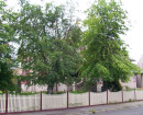
The township of Corindhap, formerly known as Break-O-Day, is located approximately 5 kms north east of Rokewood and 45 kms south of Ballarat on the Colac-Ballarat Road. The Corindhap area was originally occupied by the Derwent Company as the Wardie Yallock run (later to be known as Kurruck Kurruck), then held by a partnership which included the Atchison brothers in 1839. John Elder, who was a brother-in-law to the Atchisons, held the lease to the Mindi run between 1850 and 1857. Elder purchased the Kurruck Kurruck run in 1857, with his sons taking control of the property in 1863 and renaming it Kuruc-a-ruc in 1864. Gold was first discovered on Boundary Hill in 1852. The Break of Day Gully (Corindhap) goldfield opened in April-September 1856 with the big rush taking place there in 1861, which resulted in the population of the area reaching 5,000 at its peak. The mining was alluvial. Quartz mining was tried but was unsuccessful. Some of the existing miners' cottages could date from this period. The Break-O'Day Hotel, which survives today, was built in 1869. It is a single storey masonry building located at the main intersection of the town. The first school was established by the miners in the 1860s. Corindhap was officially proclaimed a town in 1874 and the substantial infrastructure of gutters, drains and culverts probably dates from this period. St John's Anglican Church was built in the early twentieth century and the copse of significant Pinus pinea (Stone Pines) probably dates from the same time. The Presbyterian Church has been removed to Rokewood Junction. By 1914, Corindhap was described in municipal directories as a mining and agricultural district with a State School, Church, Mechanics' Institute and Library, and Oddfellows' Hall. Its population had fallen to 300 but, with the decline of mining and relatively little employment from pastoralism and agriculture, it declined further to a stable 250 through most of the twentieth century. Only one commercial building, the former combined post office and butcher's shop, with its associated dwelling, survives from the early twentieth century. The First World War Avenues of Honour, consisting of traditional Cupressus macrocarpa (Monterey Cypress) and Pinus radiata (Monterey or Radiata Pine) were planted along in the Ballarat-Colac Road. The avenue was opened on 15 September 1917 by Cr James Boyle. Some of the latter trees situated within the Avenue, the minor deviation of the Colac-Ballarat Road, have been carved into sculptures. Perhaps the last substantial building to be erected in the township was the new Memorial Hall in 1956, replacing the Mechanics Institute. The township remains sparsely developed with many of the cottages in poor condition.
How is it Significant?
The township of Corindhap is of historical, architectural and social significance to the Golden Plains Shire.
Why is it Significant?
The township of Corindhap is of historical significance as one of the many small settlements in the Shire established on the site of gold rushes in the 1850s and 1860s, several of which have survived into the twenty-first century. It is of architectural significance for its range of very modest buildings dating from the nineteenth century, an example being the Break O'Day Hotel. The buildings are complimented by substantial avenues of honour and other mature trees, as well as the surviving infrastructure. The township is of social significance for its survival from a peak of several thousand, reflected in some surviving public buildings and cottages, to its modern population of less than one hundred. The township reflects the inter-relationship between pastoral, mining and agricultural pursuits.
-
-
Corindhap Precinct - Physical Description 1
The township of Corindhap is located approximately 5 kms north east of Rokewood and 45 kms south of Ballarat on the Colac-Ballarat Road. The ground falls from the north to the south in a gentle but obvious slope. The plan of the town is generally triangular and lies between Main Street to the west, School Road to the north and the Colac-Ballarat Road which runs north-east to south-west. The latter now deviates to bypass the town slightly. The section bypassed is now called The Avenue and includes an avenue of Cupressus macrocarpa (Monterey Cypress) which have low integrity and are in poor condition, some of which have been carved into 'statues'. The town is focused on the intersection of The Avenue and Main Street, the location of the hotel in the oblique south-east corner. Important culverts survive at this intersection and stone and concrete gutters radiate from it. The surviving buildings, all situated on the eastern side of Main Street face an open paddock of heavily worked ground, once 'Elders Front Paddock' and the location of the Break of Day Lead and the Frenchman's Creek Lead. Very little survives from the commercial activity of Main Street that once supported these diggings. The most important building, being a combined former post office, butcher's shop and dwelling, a vernacular single storey timber structure at 20 Main Street. The interior of the butcher's shop is a rare surviving example. Two public buildings, the Memorial Hall (1956), at the south-east corner of Hall Road, and St John's Church of England are located in Main Street. The latter has several important mature Pinus pinea (Stone Pines) at the rear which contribute to the landscape. The east side of Main Street is lined intermittently with small cottages. Other buildings, such as the outbuildings at 20 Bouchier Avenue, dot the precinct and the open space between the structures is important for its character. The southern approach to the town is lined by an Avenue of Honour including a mix of Pinus radiata (Radiata or Monterey Pines) and Cupressus macrocarpa (Monterey Cypress).
Corindhap Precinct - Historical Australian Themes
Australian Historic Themes
The Australian Heritage Commission devised the Australian Historic Themes in 2001. The following themes have influenced the historical development of the Corindhap Precinct.
Theme 2 Peopling Australia
2.2 Adapting to diverse environments
2.4 Migrating
2.4.2 Migrating to seek opportunity
2.4.5 Changing the face of rural and urban Australia through migration
2.5 Promoting settlement
Theme 3 Developing Local, Regional And National Economies
3.3 Surveying the continent
3.3.3 Prospecting for precious metals
3.3.4 Looking for land with agricultural potential
3.3.5 Laying out boundaries
3.4 Utilising natural resources
3.4.3 Mining
3.6 Recruiting labour
3.7 Establishing communications
3.7.1 Establishing postal services
3.8 Moving goods and people
3.8.5 Moving goods and people on land
3.8.7 Building and maintaining roads
3.12.5 Retailing foods and beverages
Theme 4 Building Settlements Towns And Cities
4.1 Planning urban settlements
4.1.1 Selecting township sites
4.2 Supplying urban services (power, transport, fire prevention, roads, water, light and sewerage)
4.5 Making settlements to serve rural Australia
Theme 5 Working
5.1 Working in harsh conditions
5.1.2 Coping with dangerous jobs and workplaces
5.6 Working in the home
5.8 Working on the land
Theme 6 Educating
6.2 Establishing schools
Theme 7 Governing
7.6 Administering Australia
7.6.1 Developing local government authorities
7.6.3 Policing Australia
7.6.4 Dispensing justice
7.6.5 Incarcerating people
7.6.12 Conserving Australia's heritage
Theme 8 Developing Australia's Cultural Life
8.6 Worshipping
8.6.1 Worshipping together
8.6.2 Maintaining religious traditions and ceremonies
8.6.4 Making places for worship
8.8 Remembering the fallen
8.12 Living in and around Australian homes
8.14 Living in the country and rural settlements
Corindhap Precinct - Physical Description 2
Contributory elements located in the proposed Corindhap Heritage Precinct:
Laidler Reserve and War Memorial, Avenue of Honor, 25 The Avenue Corindhap
Outbuildings, 20 Bouchier Ave Corindhap
Memorial Hall, 4 Hall Road Corindhap
House, 16 Kearney Street Corindhap
Stone Gutters , Main Street Corindhap
Hotel (former Break O' Day Hotel), 4 Main Street Corindhap
Bluestone Culvert, Op. 4 Main Street Corindhap
House (former Post Office & Butcher), 20 Main Street Corindhap
House, 30 Main Street Corindhap
House, 44 Main Street Corindhap
House, 60 Main Street Corindhap
St Johns Anglican Church and Grove of Pinus Pinea (Stone Pine), 74 Main Street Corindhap
Corindhap Precinct - Integrity
Most of the surviving buildings and infrastructure retains a good degree of integrity. Much of the historic fabric of the township has been lost with the long term decline in population but the overall layout of the town, major avenues of trees, key public buildings and sufficient representative examples of commercial and residential buildings survive to provide a clear sense of past and present settlement.
Heritage Study and Grading
Golden Plains - Golden Plains Shire Heritage Study Phase 2
Author: Heritage Matters P/L
Year: 2009
Grading: Local
-
-
-
-
-
OutbuildingsGolden Plains Shire
-
Former Corindhap State School No. 1906Golden Plains Shire
-
CORINDHAP AVENUE OF HONOURGolden Plains Shire
-
-