Rokewood Precinct
ROKEWOOD, Golden Plains Shire


Statement of Significance
What is Significant?
The township of Rokewood is located on the Geelong to Skipton Road approximately 70 kms north-west of Geelong. It is nestled within a curve of the Kuruc-a-ruc Creek and is situated within a broader agricultural landscape. The township was gazetted in 1852. Its allotments are generally aligned north-south to east-west, with nine regular sections to the south of Ferrars Street and three irregular sections to the north. Rokewood developed during the gold-rush years as a civic and commercial centre, servicing both mining communities as well as surrounding pastoral properties. It became an important stop on the colonial trade routes that linked the port of Geelong to the Ballarat goldfields and further west into the interior of the Western District. It was also important as a crossroads for people moving north-south. There are records of gold mining taking place in the Rokewood area as early as the 1850s, with the Mt Misery-Rokewood goldfields operating by 1852. In 1856, successful mining inspired a 'huge influx of diggers to what was known as Rokewood Rush', which continued into the mid nineteen century. By 1865, the population of 'Rokewood and the diggings in the vicinity' was about 950 persons. The township held a court of petty sessions, a post and money order office, two schools, and two hotels being the Rokewood and the Victoria. A permanent constable was stationed at Rokewood from 1857, followed by the construction of a police station in 1859. The Rokewood Presbyterian Church dominates the township. It was designed by Alexander Davidson in 1866 who, for a time, operated his architectural practice from Rokewood. It was his first major commission and the construction of its tower, the last in 1905. With his new partner, George Henderson he went on to become one of Geelong's most innovative, influential and prolific architects. The church's construction was a clear statement by the local squattocracy who were staunchly Presbyterian. The official opening of the church took place on Thursday the 23rd of August 1866.
A second gold discovery and subsequent increase in population was experienced in the late 1880s. During the post-gold rush years, the township continued to grow as the center of a prosperous pastoral and agricultural district. The township has been associated with a number of early pioneer families, who settled on large pastoral runs located in the district in the late 1830s and early 1840s, and beyond. These properties include 'Commeralghip', 'Dereel', 'Glenfine', 'Wurrook', and 'Kuruc-a-ruc' The subdivision of pastoral properties for the WW2 Soldier Settlement Scheme saw another significant increase in population and a boost to all sorts of social aspects of the town's development during the 1950s and 1960s. The war memorial and the Rokewood Memorial Hall erected in 1959 commemorates the contribution of members of Rokewood district in each of the Great Wars.
The township of Rokewood remains substantially intact and the surviving buildings and infrastructure from a range of periods retain a medium to high degree of integrity. Key public and civic buildings, open public space and surviving examples of commercial and residential development provide a clear sense of past and present settlement.
How is it significant?
The township of Rokewood is of historical, architectural and social significance for the Golden Plains Shire.
Why is it significant?
The township of Rokewood is of historical significance as one of the many small settlements in the Shire established to support nearby gold mining and agricultural industries during the 1850s and again in the 1880s. It has direct associations with several important Scottish pioneers. It is of architectural significance for its range of commercial, residential and public buildings dating from the nineteenth century, the most important being the Rokewood Presbyterian Church and the surviving row of commercial premises with attached residences on the southern side of Ferrars Street. The town is of social significance as the focus of community activity and as a representation of the inter-relationship between pastoral, mining and agricultural industries.
-
-
-
-
TRY AGAIN CO.
 Victorian Heritage Inventory
 -
UNNAMED MINES
Victorian Heritage Inventory
-
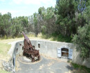
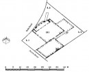
CARR & STANBROOK
Victorian Heritage Inventory
-
-