Back to search results
MERINO TOWNSHIP
High Street,MERINO, Glenelg Shire
MERINO TOWNSHIP
High Street,MERINO, Glenelg Shire
All information on this page is maintained by Glenelg Shire.
Click below for their website and contact details.
Glenelg Shire

Merino Precinct

On this page:
Statement of Significance
What is significant?
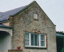
The present township of Merino, located on the Portland -Casterton Road, dates from the early 1840s and appears to have pre-empted the closer settlement afforded by the Land Selection Acts by several years. The first buildings were Paddy Curtain's eating house, located on the banks of the Merino Creek and the waterholes to the north of the township. The plan of suburban allotments around in the Parish of Merino in 1855 shows only four sections laid out. A more detailed survey undertaken of the town in 1857, when the area was formally gazetted shows then allotments, many already sold, and only two permanent buildings on the land of F. Egan, on the southwest corner of Hare and High Streets. Interestingly, no reserves are set aside in the original survey, although the Catholic Church was granted land in 1861. The Merino Creek, which once provided a reliable water source to the early inhabitants of the town, has acted as a barrier to development to the west, and all subsequent development has occurred up the hill to the east of the town. The town is laid out in the standard grid pattern, with High Street being the main commercial and civic street. The main civic buildings are clustered together, the Court House (moved in from Digby in 1870), the Police Barracks (former), the Mechanics Institute and the Post Office all stand near the corner of Burke and High Streets. The streets running parallel to High Street, ascending up the slope of the hill contain most of the early residences, the school and the religious buildings. The industry of the town was also located in the centre, often adjacent to the creek, such as the brick Flour Mill, built in 1857. Unlike most towns of this size, Merino has a main carriageway running through the centre of the road reserve, with service roads on both sides, and plantings between the main and service roads. These are mainly part of the World War One Avenue of Honour, planted in 1932 to replace the street trees (Radiata Pines). They are supported by the war memorial, dating from 1918, located in the centre of the town on the corner of Maud and High Streets. The churches are located high on the hill overlooking the town, and are outside of this precinct. The town is in good condition and retains a good level of integrity.
How is it significant?
The Merino Heritage Precinct is of historic, cultural, social and architectural significance to the Glenelg Shire.
Why is it significant?
The Merino Heritage Precinct is of historic significance as a township dating from the early 1840s, as one of the chain of small settlements between Portland and Casterton, which developed as the major centres in the area, and for representing the emergence of various aspects of agriculture, especially closer settlement, soldier settlement and diarying in the area. It is of social significance as the focus for the community's commerce, religion, education and recreation, roles that continue to the present. The architectural significance of the town lies in range of buildings constructed from local materials over a long period of time, ranging from the fine religious buildings through to the humble timber cottages which remain.
Show more
Show less
-
-
-
-
ST PETER'S ANGLICAN CHURCH (FORMER)
 Glenelg Shire
 -
ST. ANDREWS PRESBYTERIAN CHURCH (FORMER)
Glenelg Shire
-
Winninburn Homestead & Men's Quarters
 National Trust
-
3 Sherwood Street
 Yarra City
 -
Archaeological site
 Southern Grampians Shire
 -
BLACKWOOD HOMESTEAD COMPLEX AND CEMETERY
Southern Grampians Shire
-
-