GOLDEN POINT WORKINGS, FIERY CREEK LEAD
MAIN LEAD ROAD MAIN LEAD, PYRENEES SHIRE
-
Add to tour
You must log in to do that.
-
Share
-
Shortlist place
You must log in to do that.
- Download report


Statement of Significance
This record has minimal details. Please look to the right-hand-side bar for any further details about this record.
-
-
GOLDEN POINT WORKINGS, FIERY CREEK LEAD - History
Heritage Inventory History of Site: The Fiery Creek Lead was opened during the great rush to the area in 1855. The gullies running into the main lead proved to be very rich. The main lead and its tributaries were worked by both sluicers and puddlers. The mining registrar lists, in 1861, the Dancing Feather and Phoenix sluicing company as sluicing near Golden Point. Puddling was also widely used when the washdirt proved unsuitable for sluicing. While many puddlers were able construct their own dams, some paid a rent to the sluicing companies for the water they required to carry out their vocation. The mining registrar pinpointed Upper Golden Point (on the Main Lead) as a favoured puddling location - there were seven puddling parties (6 European and 1 Chinese) were working with great success in 1861. Six of the puddling parties were renting water from the Phoenix and Wimmera sluicing companies, and the other had its own dam.The upper parts of the Fiery Creek Lead were dredged in the early 1900s. The auriferous ground at Golden Point was last worked in the 1940s, by Norm Dickman's father.Heritage Inventory Description
GOLDEN POINT WORKINGS, FIERY CREEK LEAD - Heritage Inventory Description
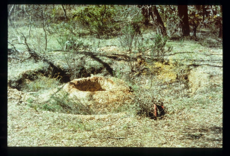
Shallow alluvial landscape, the product of different mining methods - shaft sinking, ground sluicing, water races and puddling. Main puddling features include: Large (200 metres wide) open cut - Identified by Norm Dickman (local resident) as where his Dad removed everything for treatment in nearby puddler. The shallow sinkings to the south of the open cut have been disturbed by recent mining operations. An 18ft diameter puddler (1) - Located on west bank of open cut. Inner mound is pronounced and puddling trench has sheer walls. No pivot post or trench slabbing. Intact pebble-wash dump, 14 metres wide and 2 metres deep. Adjoining puddlers - Located 75 metres south-west of puddler (1). The southern-most puddler has been partly destroyed by a track and what survives is extremely weathered. The second puddler is located five metres away, and although in better condition it has been partly excavated by gold fossickers. This puddler was identified by Norm Dickman as the one operated by his Dad in the 1940s./n
Heritage Inventory Significance: The site has: Scientific significance - relatively undisturbed shallow alluvial landscape Network significance - part of a network of sites that illustrates different periods of alluvial mining SIGNIFICANCE RANKING: Regional
Recorded by: David Bannear
Heritage Inventory Site Features: - shallow alluvial landscape, the product of different mining methods - shaft sinking, ground sluicing, water races and puddling. - large (200 metres wide) open cut. - 18ft diameter puddler (1) - adjoining puddlers
-
-
-
-
-
TIPPERARY GOLD PUDDLING SITE
 Victorian Heritage Register H1250
 -
FIERY CREEK DREDGE HOLE
 Victorian Heritage Inventory
 -
TIPPERARY GULLY
 Victorian Heritage Inventory
-
-


