PEACH POINT ALLUVIAL MINING AREA
OFF BUCKLAND ROAD BUCKLAND AND BUCKLAND RIVER BUCKLAND, ALPINE SHIRE
-
Add to tour
You must log in to do that.
-
Share
-
Shortlist place
You must log in to do that.
- Download report
Statement of Significance
-
-
PEACH POINT ALLUVIAL MINING AREA - History
Heritage Inventory History of Site:
The Buckland River was sluiced for gold from 1855. An estimated 6,000 diggers were swarming up the Buckland River valley by January 1854. Soon after, the rush was abruptly halted by an outbreak of 'colonial fever'. Within a few days, most of the diggers were either dead or had fled. For years afterwards, the Buckland was known as 'The Valley of the Shadow of Death' and was largely shunned by diggers until early in 1857 when there came a great number of Chinese.
On the Ovens River and Morse's and Growler's Creeks in 1860, the quartz mines were the focus of activity; but only nine of the more than 1,200 miners on the Buckland were reef miners. The rest were occupied in sluicing the beds, banks and flats of the river and its tributaries. A network of races wove along either side of the Buckland, and the river's course was already becoming choked with tailings from sluicing claims on the banks. The higher flats were worked by hydraulic sluicing, using large sluice boxes and a strong head of water (hence the water-races), while the waterways and the lower flats were 'paddocked' or stripped of their goldless overburden and the washdirt then raised to the sluice. Small waterwheels drove Californian or elevator pumps to drain the lower claims.
The vast majority of alluvial miners on the Buckland River were Chinese. In what became known as the Buckland Riot ('the most disgraceful of the Victorian riots'), an estimated 2,000 Chinese miners were driven out of the Buckland valley in July 1857 by a mob. Their camps, about 300 tents and 'tenements', stores, and a joss house, were looted and torched, and their possessions destroyed. According to official report next day, 'Broken shovels, cradles, picks, torn garments, ripped up bedding, half-burnt clothing, battered buildings, whole quarters of beef and mutton trodden into the mire, the earth bestrewed with rice, empty sugar bags, and broken tea boxes, were the chief features of the late home of the Celestials.' The Chinese miners were themselves beaten and some, it is claimed, were murdered as they were hounded up the river valley by the mob. Twelve men were charged over the riot: three were found guilty of unlawful assembly and one of riot. The Chinese were dismissed as 'deceitful' and their evidence discredited, as was that of the European wife of one of them, who had herself been beaten by the mob. It is said that the rioters were principally American and Irish miners, who bore the Chinese the strongest enmity, and that the escaping Chinese were aided, and the rioters condemned, by the English and Scottish of the district. After the discovery of reefs in the area in 1860, the Chinese began filtering back to the Buckland, being more confident that they would be left unmolested to work the 'exhausted' alluvial ground.
In 1864, there were close to 2,000 Chinese alluvial miners among a total mining population of 2,500 on the Upper Ovens/Buckland goldfield. Alluvial mining was at that time centred on the Buckland River (1,280 miners), especially the Lower Flat (680). At the end of 1866, the mining registrar wrote of shallow alluvial workings (i.e., sluicing) on the Buckland River: 'This branch of mining gives employment to nearly the whole of the local mining population, and through their labours is produced the larger portion of the gold sent from the entire division, although the Buckland has been opened since 1852, and has been looked on as being worked out.' Soon after, it seemed that the older Buckland workings were indeed becoming exhausted. Some Chinese were leaving, and water-races commanding the best sluicing grounds depreciated in value nearly 50 per cent in 1867. In 1871, more European miners were trying shallow alluvial mining, many Chinese co-operative parties (4 to 12 men) had broken up, and claims were increasingly being worked by cradle. 'In some instances on the Buckland,' wrote the mining registrar, 'the European owners of water-races take sleeping shares in Chinese claims, as compensation for use of water. Water-race property, once so valuable, is now almost worthless, no race would fetch £500 if sold.' And so shallow alluvial mining on the Buckland wound down.
It is possible that large-scale hydraulic sluicing operations took place on the Buckland (as in other rich alluvial areas) during the last decades of the 19th century, but no record of such operations has been found. According to a report in 1903: 'When the individual miner ceased to make river bed mining remunerative, sand pumps were tried on the Buckland, not with much success, though. The Buckland River wash was unsuitable for the sand pump, 40 per cent of it being too coarse to go through the runner blades. On the other hand, being free of clay, the river turned out to be ideal for bucket dredging. From the turn of the century until 1920, the Buckland River, like all the upper Ovens waterways, was worked by dredge. No doubt hatters and small parties of miners tried their luck on the Buckland during the depression years of the 1930s. The last report found of alluvial working on the Buckland River dates to the late 1950s, when Corrigan and Co. were sluicing on high terrace ground above the river, about 11 km south of Porepunkah.SiteCard data copied on 10/07/2024:Maguires Point to the south was location of the first rich gold discovery on the Buckland. Peach Point a short distance to the north would have been worked within weeks of the rush to the area. Alluvial mining was carried on here from the earliest days on the Buckland diggings, when most miners were engaged in panning, cradling and small-scale ground-sluicing. Californians introduced various sluice washing techniques from early 1854, and cut many water-races to wash high points and banks all along the river. Hydraulic mining was said to have been first used on the Buckland by John Reid and party in 1858. This technique involved the use of canvas hoses to deliver water under pressure for the washing of alluvial gravels. This technology further developed into higher pressure sluicing operations with the introduction of improved nozzles, steel pipe and higher-level water-races. By the 1890s, jet-elevator technology was in common use on the field. The large hydraulic sluice pit and cobble field may have been associated with the Robinson’s company workings of the late 1890s. The following article and the historic features seem to suggest the workings were that of the mentioned company. “North of Murray’s Creek Messrs. W. and P. Robinson are fortunate in having ground, which when water is not available in the summer for running off in a face pays well for driving out. The company holds reservoirs which hold sufficient water to wash all the dirt obtained during the driest season. The claim itself has paid well for several years, and there is yet a lot of ground unworked. Now that rain has fallen hydraulic sluicing will be resumed, everything having been put in order previously.” Ovens & Murray Advertiser, 24th July 1897.PEACH POINT ALLUVIAL MINING AREA - Interpretation of Site
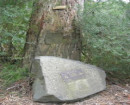
Hydraulic sluicing pit The hydraulic slucing workings, which date to the early 20th Century, extend for a length of approximately 500 metres along the river. The cliff of the main paddock is approximately 15m high, running along the eastern edge of the Buckland Valley Road. Vast cobble dumps or fields extend between the cliff and the river, with a series of stone-lined or retained tail races. The north end is mostly obscured by tea-tree and blackberries. Several main tail-races extend between the face and the river. These are rock-retained, and in places cut down into the bedrock to a maximum depth of approximately 2.5 metres. Heavy vegetation grows along most of their length. The large moss-covered cobble heaps have stone-retaining walls in places, and the whole open area has a decaying, ‘Aztec city’ appearance. Next to one of the main tail-races in the centre of the site are some ironwork artefacts. These include lengths of steel pipe (including an elbow), some punched-steel plate, bolts etc. These may be associated with the gold recovery, and/or sluice boxes. Immediately below this, beside the tail-race and on the site of a cobble heap, are various steel riffle sections and punched-hole, steel plate gratings from a sluice box. Some early goldfield glass fragments are visible occasionally amongst the cobble heaps, indicating that earlier camps may have been sluiced away. Earlier alluvial workings – Peach Point South A lead channel has been worked by ground sluicing and alluvial drives in order to access the gold bearing gravels of an ancient former course of the river, separated from the current course by a large area of bedrock. This area remains as an elevated flat between the old river course workings and the present day river. The flat itself also contains evidence of alluvial surfacing. This locality was one of the first areas rushed in 1853, and is marked on old goldfield maps as Peach Point. The origins of this name are not known. In the early days of this goldfield a deep tailrace that divides this flat was cut deep into the bedrock to a depth of approximately 10 metres. It is highly probable that early miners were camped on this flat. Although no hut or camp sites could be clearly identified, there were several rubble piles on the flats area that could be consistent with early occupation sites. The occasional fragment of early goldfield bottle glass and ceramics were also evident. Hand-steel drill holes are still evident in the hard bedrock walls of this ravine, indicating gun-power, or a similar form of explosives were used in the excavation of this deep tail race. Peach Point South – Burial site A possible burial site was located on the elevated flat, on the southern side of the tailrace. The burial site is aligned in an east-west direction at a bearing of 272 degrees, with the head of the grave facing east. The grave is defined by a rectangular formation of stones, measuring 2,200 mm in length x 950-1000 mm in width. There are 3 rocks that have been placed in a line at the head. The central rock is larger, with evidence of anthropogenic flaking on the surface. Earlier alluvial workings – Peach point North, including reservoir To the north of the main hydraulic sluicing pit is a surviving elevated area of bedrock that forms a narrow divide between the 20th Century hydraulic slucing pit and earlier ground/ bank sluicing pits. This surviving bedrock bar contains early evidence of alluvial surface workings, and like the surviving flat to the south may contain evidence of early occupation sites. The unexcavated paddock area to the west of the ground/bank sluicing works also contains a potential building site. Given the proximity of this area to the gold field workings and to the main road, it is highly probable that this area was also an early goldfields occupation area. Immediately to the north of the main hydraulic sluicing pit is a square shaped dam/reservoir that has been formed by building up of earthern banks around an excavated area. This feature retains evidence of a channel leading from the south-eastern corner of the reservoir, and extending in a northerly direction to feed head races that were being utilised for the ground/ bank sluicing works. This reservoir is likely to be associated with the earlier mining period and may heve been used for the purchasing of water during the night (cheaper rate), with water being sold in this way from 1854/1855. The square shape of the reservoir, which is unusual for its era, may have been to assist in measuring of water. Sluice Box – 20th Century workings (pre–World War II) An insitu sluice box operation is located beside the river, directly south of the river ford, in the northern area of Peach Point. The sluice box is located at the end of a tail race that extends from the main hydraulic slucing pit. The sluice box operation is at an orientation of 60 degrees and is 3,630 mm in length. The sluice box consists of two sections that have been rivetted together at 1,830mm. The sluice box is 320 mm in width and 380 mm in height. There are 9 x sluice sectioned base plates scattered around the sluice box. These measure from 870 mm – 1010 mm in length x 300 mm wide x 30 - 35 mm in thickness. A tail race riffle is also located in the bed of channel leading to the sluice box. The riffles are constructed from reused flat bar with an average length of 1,280 mm, width of 65mm x 8mm in thickness.
Heritage Inventory Description
PEACH POINT ALLUVIAL MINING AREA - Heritage Inventory Description
The banks and terraces of the Buckland River have been extensively sluiced for at least 7 km upstream from the Buckland Cemetery to the Junction. A large extent of the workings have become overgrown with blackberries, etc. The following sites were recorded because of their relative visibility/un-vegetated state./nSluiced open cut and tailraces - A large sluiced open cut with stone-retained pebble dumps and several tailrace cuttings./nSluiced landscape - A 20m-high vertical face overlooks a vast pebble dump. Several tailraces are visible (marked by lines of trees and vegetation). There is an area for vehicle parking near the viewing point./nSluiced open cut and tailrace - On the opposite side of river to the camping ground is a relatively small sluiced open cut, measuring approximately 100 m x 50 m x 10 metres deep. The base of the open cut is covered by a high pebble dump, through which runs a tailrace. The tailrace is approximately 8 ft deep and 5 ft wide, and connects into a major drainage race running along the eastern side of the river. The drainage race is stone-retained in places. There are several other open cuts to the south (upstream). These are all much larger and deeper but more overgrown. Presumably their tailraces connect into the same drainage race.
Heritage Inventory Significance: Regional
SiteCard data copied on 10/07/2024: The Peach point Alluvial Mining Area is a relic gold field landscape within the Buckland Valley that contains extensive evidence of the changing technologies applied in gold extraction from the 1850’s to the mid 20th Century. The site includes large sluicing paddocks (hydraulic & ground/bank sluicing) as well as infrastructure and relics associated with other earlier shallow alluvial workings, including areas of occupation.
-
-
-
-
-
BUCKLAND RIVER HYDRAULIC GOLD SLUICING PADDOCK
 Victorian Heritage Register H1224
 -
PEACH POINT ALLUVIAL MINING AREA
 Victorian Heritage Inventory
-
-


