YACKANDANDAH CREEK GORGE GOLD SLUICING WORKS
BELLS FLAT ROAD YACKANDANDAH, INDIGO SHIRE
-
Add to tour
You must log in to do that.
-
Share
-
Shortlist place
You must log in to do that.
- Download report
Statement of Significance
What is significant?
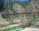
The Yackandandah Creek Gorge Gold Mining Diversion Sluice consists of a 65 metre long stone diversion sluice and associated pebble dumps, and a 200 metre long tail race. The embankment was used to divert the waters of Yackandandah Creek away from its natural bed which was then mined for its alluvial gold. The tailrace was cut in 1882 by the Premier Company when they sluiced Rowdy Flat.
How is it significant?
The Yackandandah Creek Gorge Gold Mining Diversion Sluice is of historical, archaeological and scientific importance to the State of Victoria.
Why is it significant?
The Yackandandah Creek Gorge Gold Mining Diversion Sluice is historically and scientifically important as a characteristic and well preserved example of two early forms of gold mining. Gold mining sites are of crucial importance for the pivotal role they have played since 1851 in the development of Victoria. Water diversion and sluicing are important key ingredients in an understanding of gold mining technology as it was employed in mountainous country where water was plentiful and perennial.
The Yackandandah Creek Gorge Gold Mining Diversion Sluice is archaeologically important for its potential to yield artefacts and evidence which will be able to provide significant information about the cultural history of gold mining and the gold seekers themselves.
[Source: Victorian Heritage Register]
-
-
YACKANDANDAH CREEK GORGE GOLD SLUICING WORKS - History
Heritage Inventory History of Site:
An 1860 map included a notation describing the position of 'One of the expensive tailraces mentioned in my reports blasted thro' granite' . Its position corresponds with that of the present-day upper gorge. A mining surveyors' report of December 1859 appears to refer to the same tailrace: 'Messrs Edwards and party's tailrace at the bridge, near the Bridge Inn, on the road to the township is completed. The greater portion was cut through granite, and boxed throughout its entire length.' In 1854 a sawmill had been erected on Yackandandah Creek, and Edwards' claim (worked from 1857) took in the 'Falls of sawmill tail race'.
The lower gorge was apparently constructed when the Premier GMC (Jessop & Fletcher) excavated a 100m-long tailrace in 1882, cut through hard rock to a depth of more than 2m in places. The Premier Co. had a sluicing lease at Rowdy Flat, on the creek just north of the township. The race was extended in 1885.Heritage Inventory Description
YACKANDANDAH CREEK GORGE GOLD SLUICING WORKS - Heritage Inventory Description
Yackandandah Creek Gorge- 1996 site description Yackandandah Creek Gorge tail race comprises two channels, an upper and a lower, and stone-retained dam embankments. An interpretive trail has been established for the site. Heritage Inventory Significance: National Estate. The site has scientific potential because of its rarity and educational potential. Heritage Inventory Key Components: Upper channel - Stone-retained walls and channel cut through granite, 10 ft deep, 8 ft wide and runs for approximately 200 ft. The channel is dry, blocked off from the present course of water by a concrete wall. The north end of the channel is completely obscured by blackberries, making it impossible to establish its relationship with the lower channel. Several dumps of pebbles are located at the northern end of the upper channel. Lower channel - Cut through granite, 10 - 15 ft deep x 8ft wide x approximately 600 ft long. The lower channel now forms the present course of Yackandandah Creek. Embankments - A stone-retained embankment runs across the dry original bed of Yackandandah Creek, on the eastern side of the tail race. It is 75 ft long and 6 ft wide and constructed of granite blocks and clay mortar. A second, smaller embankment has been placed across the mouth of a tributary to the creek. Yackandandah Creek Gorge Gold Sluicing Works- 2020 site description The whole of the area alongside the Yackandandah creek, within Crown land, between the Yackandandah Gorge site (H1254) to the north and Bells Flat Road, where the creek turns south east, represents a landscape impacted heavily by gold mining activity, especially sluicing. Gold mining sluicing activity took place here in the later phases of Yackandandah's gold mining history. The edges of the creek valley were all cut away by the sluicing though probably exacerbated by subsequent erosion. Mounds of soil, pebbles and gravels were noted throughout on the valley floor and in the creek, likely deposited during sluicing as sludge. Several soil ditches or channels (water races) were also noted that are likely associated with the gold mining sluicing activity. There were several in the middle part of the subject area and another set at the southern end. There was also a set of terraces possibly used for supporting sluice boxes. These features and the potential for deposits and buried artefacts throughout mean this area should be listed as an archaeological site.
-
-
-
-
-
YACKANDANDAH CREEK GORGE GOLD MINING DIVERSION SLUICEVictorian Heritage Register H1254
-
TWISTS CREEK TIMBER MILL SITEVictorian Heritage Inventory
-
YACKANDANDAH CORDIAL FACTORY SITEVictorian Heritage Inventory
-
-