Point Lonsdale Lighthouse Precinct
Point Lonsdale Road POINT LONSDALE, QUEENSCLIFFE BOROUGH

-
Add to tour
You must log in to do that.
-
Share
-
Shortlist place
You must log in to do that.
- Download report


Statement of Significance
Statement of Significance as recorded under the Queenscliff Heritage Study 2009
The following is the Heritage Victoria statement of significance:
What is significant?
The Point Lonsdale Lighthouse precinct consists of the lighthouse and associated buildings [both extant and ruins], and defence structures associated with the First and Second World Wars. The area was first used in the mid-nineteenth century for the construction of navigational structures to guide vessels through the Heads of Port Philip Bay.
European discovery of the entrance to Port Phillip Bay occurred in 1802 when Acting Lt John Murray in command of the Lady Nelson sighted the promontories now known as Point Lonsdale and Point Nepean. With the later exploration of Port Phillip Bay and the consequent development of the towns of Geelong and Melbourne, safe navigation through the dangerous Port Phillip Heads was of critical importance. The promontory at Point Lonsdale provided an obvious location for the placement of navigational guidance structures. Although a flagstaff had been manned from 1852 and a warning light shown, the first lighthouse was not erected until 1863 when the former timber leading light at Shortlands Bluff which had been constructed in 1853-54 was relocated to Point Lonsdale. Lighthouse keepers' quarters [since demolished] were also constructed in the 1860s and in 1884, a weatherboard foghorn shed was constructed at the site. In 1891 a building for the storage of explosives held to blast a navigation channel near the jetty constructed was erected in the place of a former powder magazine. The store was later used as a rocket shed. The jetty was erected c.1890 to house a lifeboat in accordance with the recommendation of the Commissioner of Customs following the wreck of the barque Glaneuse in 1886.
The Point Lonsdale Lighthouse constructed in 1901-02 is the last remaining of the three successive light structures erected at Point Lonsdale. The lighthouse was designed by the Public Works Department and the reinforced concrete structure was erected by the contractors Coates Brothers. The lighthouse was first lit on 20 March1902. In 1951 an octagonal structure housing the signal station and observation room was built around the base of the lighthouse.
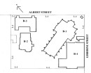
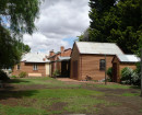
The principal light station related structures remaining at the point are the lighthouse [1901-02], fog horn shed [1884], the rocket shed, which contains two rare vertical boilers [1891], the jetty [c1890], the scend shed [1941], the signal mast [1951], and the remains of the lighthouse keepers quarters [1860s].
The Point Lonsdale lighthouse is of a traditional design consisting of a shaft and capital and closely follows the form of many late nineteenth century Victorian lighthouses. The structure is mass concrete tower similar in construction to the earlier Point Hicks lighthouse. The structure is surmounted by a Chance Brothers lantern. The original oil lamp of the light was replaced first with an acetylene light and later an electric light. Half way up the shaft is a cantilevered platform supporting red and green navigation lights which replaced a subsidiary light original to the 1901-02 structure.
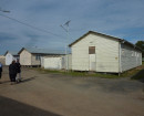
While Point Lonsdale had always been of strategic defence interest, it was the outbreak of the First Word War which prompted the construction of defence structures in the vicinity of the lighthouse. Two search light emplacements, an electric light directing station and engine house were constructed in 1914. Further defence structures were erected in response to the commencement of the Second Word War. A new concrete emplacement, now the scend shed, was constructed in 1941 and two gun emplacements and a fire directing emplacement were added in 1942. At about the same time, the Point Lonsdale defence camp was erected. The camp, consisting principally of P1-type huts, initially accommodated the 7 Australian CRE [Works] and with a small area set aside on the east side of the Point Lonsdale Road for the Australian Women's Army Service [AWAS]. At the height of the war, there were fifteen camp buildings at Point Lonsdale. In 1946, the service personnel social and benevolent organization Toc H applied to use the camp buildings as holiday accommodation for children of former members of the services. Toc H later purchased the buildings and continues to lease the land from the Victorian Government.
How is it significant?
The Point Lonsdale Lighthouse precinct is of architectural, historical and archaeological significance to the State of Victoria.
Why is it significant?
The Point Lonsdale Lighthouse precinct is of historical significance for its association with the maritime and defence history of Victoria. The lighthouse structures in the precinct demonstrate the importance of a system of navigational aids in a time when shipping was of singular significance in maintaining commercial links between Melbourne and Geelong and Britain and Australian colonial ports. The Point Lonsdale lighthouse was of critical importance as the first guiding light to the entrance of Port Phillip Bay visible from sea. The defence group is of historical significance for the range of fixed defence structures within the site, reflecting the importance of the defence of Port Phillip Bay and the major cities of Melbourne and Geelong during the duration of both the First and Second World Wars. The P1-type huts are of interest for their association with the 7 Australian CRE [Works] division, the Australian Women's Army Service [AWAS], and the Toc H organization.
The Point Lonsdale Lighthouse group of buildings is of architectural significance for its lighthouse which is a typical and aesthetically pleasing example of an early 20th century lighthouse design, and the ancillary structures and fittings. The fog horn shed is the only known fog horn shed at a Victorian lighthouse and the two vertical boilers which provided the power for the steam operated fog-horns are rare in their original setting. While there are rocket sheds at three other Victorian light stations the rocket shed at Point Lonsdale is the only one located in close proximity to a lighthouse.
The Point Lonsdale Lighthouse precinct is of archaeological significance for its potential to reveal significant artefactual remains pertaining to the use of the place as a lightstation and signal station. Sites in the vicinity of the demolished keeper's buildings have a high archaeological potential.
-
-
Point Lonsdale Lighthouse Precinct - Usage/Former Usage
In 1865 the area now known as Point Lonsdale was designated a Battery Reserve and was essentially undeveloped land other than around the lighthouse area. At that stage the area boasted a timber lighthouse that had previously been the leading light at Queenscliff, a telegraph station, flagstaff and array of other assorted buildings including a powder magazine. These buildings have now all been demolished and in most cases replaced with new buildings including the concrete lighthouse built in 1901-02 and the pier built in 1889-90.,
The area is important historically in its association with the early history of the Borough and the Pilot Service and as the first part of the Point to have any substantial development. As it stands today the precinct still retains structures that relate to both the nineteenth and twentieth centuries and illustrates the changing nature of coastal navigational and defence installations. In addition the precinct is one of natural beauty and environmental significance and retains the typical coastal vegetation that appears to have always existed in the region.
On a broader level the area also derives significance from the presence of Buckley's Cave, the purported residence of a person of some significance in the history of European presence in the colony.
Point Lonsdale Lighthouse Precinct - Physical Description 1
Landscape
The landscape in this area is heavily wooded with low Tea Trees largely concentrated on the landward areas and with grass, bracken and low scrub on the seaward areas. The area appears from early photographs to have been relatively sparsely covered originally and it is only in the last eighty to ninety years that the growth has occurred. The vegetation in this area should be retained and supplemented where necessary.
Point Lonsdale Lighthouse Precinct - Physical Description 2
Extract from the 2009 study
The precinct includes Point Lonsdale Lighthouse, Point Lonsdale Pier, Buckley's Cave, the three fortified searchlight emplacements to the east and south, the flagpole and its emplacement, the timber store and the two brick powder stores, the sea wall along the section of Point Lonsdale beach enclosed by the precinct, the dunes and scrub between the boundaries and the beach fronts to east and south.
Lighthouse: Designed as a shaft and capital, the circular lighthouse reduces with a cavetto mould, terminating on an astragal, to a tapered white shaft which continues to the ground. Subsequent to its construction, an octagonal structure housing the Keepers' Station and an observation room was built at its base. Over half way up the shaft, a cantilevered platform supports the red and green lights. The original oil lamp of the light was replaced first with acetylene light and, later, an electric light. The present tower replaced a timber structure built in 1865 (refer HO84).
Buckley's Cave: A natural feature in the Point Lonsdale escarpment associated with William Buckley, who escaped from the first penal settlement at Sorrento in 1803 and lived for much of this time in a hut near Breamlea, 23 kilometres away, until giving himself up in 1831. It is thought that he used the cave as an observation point for passing ships. Subsequent to his Point Lonsdale stay Buckley became an interpreter for John Batman and other early Melbourne settlers (refer HO94).
Military emplacements: A series of reinforced concrete emplacements were installed around the lighthouse in the late 1930s and early 1940s. These included searchlight emplacements with swivel mounting and associated rooms for crew. Each of the surviving emplacements has two rooms; one with a reinforced concrete swivel mounting and the second a windowless space behind. Entry is through a set of steps that descend into each shelter. The first is placed at the head of the beach, being partly built into the cliffs. The second is immediately below the lighthouse, near Buckley's Cave. The third is on the main dune rise to the west of the main lighthouse tower.
Each emplacement is partly set into the sand, two facing south toward Bass Strait and one facing east toward The Rip. The front chamber has an open space for traversing a light or weapon; this is sheltered by a reinforced concrete slab cantilevered over the working space immediately below it. All three have reinforced concrete side walls, mostly c. 30 cm thick. The flooring appears to be reinforced concrete also. Two at least have reinforced concrete mounts inside to support the lights or gun that was intended.
An enclosed space immediately behind could have served as a work room, rest space, shelter or plotting room. Entry from outside is down a short flight of concrete stairs, rather in the manner of contemporary air-raid shelter design. They are weakening with time, and the central south emplacement is off limits as the structure is considered unsafe.
Stores: Two apricot-brick magazine buildings are on the lighthouse site, one immediately below the lighthouse on the township side, the other on a low sand ridge between the main turning circle and the eastern beach. Both buildings have pitched roofs and thick brick walling.
Pier: The present pier (original 1886) was instigated primarily to move the lifeboat service closer to the Rip entrance, after the Glaneuse ran aground there. In its original form it included a covered davit for the lifeboat, enveloping its far end. The original lifeboat canopy and its davit have been removed, and it resembles the piers at Rye, Sorrento, and elsewhere in being a simple plank-topped structure. Much of its fabric has been replaced.
Flagstaff: The current flagstaff was raised in 1951, and connected to the main lighthouse by a concrete ramp with intermittent steps. The basalt table at its foot, including a commemorative stone, appears to date from the same period.
Toc H Camp: This appears to have been built in the 1940s or early 1950s. Its main role was to provide holiday accommodation and activities for children of war veterans. It included a hall and dormitories, its original amenities block appears to have been replaced in the early 1960s. In its present form it comprises a hall for assembly and recreation, and five dormitory blocks, connected by a set of concrete paths. It reflects the widespread activity of the Toc H organisation, especially during World War II and the period immediately following, and stands as quite a large monument to Toc H activities. There are all timber buildings with asbestos-cement cladding and low-pitched roofs clad in corrugated galvanised steel or corrugated asbestos cement sheeting. In addition there is a cream brick amenities block with toilets and showers, in a hollow immediately below the other Toc H buildings. In appearance the dormitories and hall buildings date from the 1940s, with the toilet block looking later, probably early 1960s. The hall had later additions, again probably in the early 1960s. The camps activities centred round children of war veterans, providing activities and a holiday for them. They appear to have been disused for some years. The original buildings were all in a fairly basic wartime emergency style and the complex resembles a military installation.
Demolished and non-contributory buildings: The precinct also accommodated various buildings which have been demolished, but for which there may still be archaeological evidence. These included the first timber-framed lighthouse of 1865, replaced by the present tower in 1901-2, and an early powder magazine later replaced by the two brick stores and the timber store next to the lighthouse tower. The precinct also included other now-demolished buildings and an earlier flagstaff, replaced in 1951. Three family houses of a standard suburban 1970s type are inside the precinct boundary on a continuation of Point Lonsdale Road, immediately south of the Ocean Road turnoff and north of the Toc H camp. There is also a public toilet block in stone and concrete on the foreshore.
In addition the precinct is a place of natural beauty and environmental significance and retains typical coastal vegetation.
(Queenscliffe Urban Conservation Study, Allom Lovell and Associates, 1984; and Barry Hill, The Enduring Rip: a History of Queenscliffe, Melbourne University Press, 2004; and additional research by Lovell Chen, 2008)
Heritage Study and Grading
Queenscliffe - Queenscliffe Urban Conservation Study
Author: Allom Lovell & Associates P/L, Architects
Year: 1982
Grading:Queenscliffe - Queenscliffe Heritage Study
Author: Lovell Chen
Year: 2009
Grading:
-
-
-
-
-
POINT LONSDALE MARITIME AND DEFENCE PRECINCTVictorian Heritage Register H1517
-
-
-
-