MILLBROOK HOMESTEAD RUIN
LOEMANS ROAD BULLA, HUME CITY
-
Add to tour
You must log in to do that.
-
Share
-
Shortlist place
You must log in to do that.
- Download report


Statement of Significance
-
-
MILLBROOK HOMESTEAD RUIN - History
In about 1850 John Pascoe Fawkner purchased Section 10 of the Parish of Tullamarine at the Crown sales, 448 acres with a frontage onto Jacksons Creek. Towards the end of 1852 Fawkner conveyed three small parcels of this land, lots of about 20 acres each to Thomas Collins, a 'carter' from Collingwood, John Jones, a 'labourer' from Melbourne, and another named Charles Boone whose occupation is unknown. These arrangements would appear to have been undertaken under the guise of Fawkner's 'Victoria Co-operative Freehold and Land Investment Society', a co-operative to which members contributed a joining fee and weekly instalments to enable them to acquire portions of the larger allotments in which Crown lands were sold.
Despite the creek frontages, the land areas were small, stony, and steep, and none of the Tullamarine purchasers in the vicinity of the Organ Pipes persisted on their new land. In 1855, Charles Boone sold the northernmost block to William Bedford, 'farmer' of Tullamarine, and in 1856 Bedford purchased the block to the south from Thomas Collins. Eleven years later, in 1867, he added Jones' block, to the south, which had the best creek frontage. The extant ruin's location situates it on the southern boundary of the portion originally taken up by Collins which the Bedfords bought in 1856. This is the year in which Caroline Bedford records the family taking up residence on the land, and it would therefore appear that the ruin dates at least from 1856, andperhaps before. The property was known as 'Millbrook' by the turn of the 20th century, so this was probably the name given by the Bedfords.
Henry Ernest Hall, a Melbourne tea broker, purchased the amalgamated three sites in 1889-90, and then acquired other nearby allotments over the next 15 or so years, but it seems that he never lived on the site or in the house. Personal accounts describe the house as 'basically a mud house, with some stone' (Moloney 2003). These may have been replaced with the brick walls which survive in the ruin. The Hayes family occupied the building for two years in the early 1920s, and one of the daughters recalls that the house was pulled down after they left. After the Hayes' left the property it was purchased by Stanley Keast, 'grazier' of Caulfield, and then passed to BH Edwards, 'gentleman' of Hawthorn.
Millbrook was well known for its orchard of apricots, almond, walnut, lemon and cherry plum trees. It was irrigated at some stage, the foundations of its pump and engine surviving in the early 1970s.
Organ Pipes National Park was established in 1972 on the degraded farmland around Jacksons Creek in an attempt to reestablish an area of the indigenous vegetation of the district.
(Derived from Moloney 2003)
MILLBROOK HOMESTEAD RUIN - Interpretation of Site
The stone and brick ruins of a house and outbuildings are situated on the side of the hill above the 'Organ Pipes'.
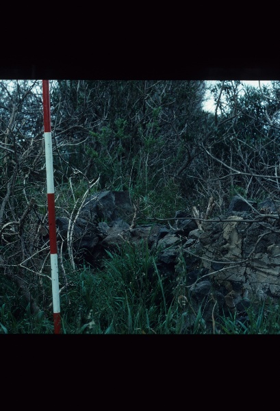
The ruins are considerable in extent and integrity. The house seems to have been built in several stages. Its south end consists of bluestone outer and inner walls about 7.5 by 3.5 metres, up to 1.5m high.
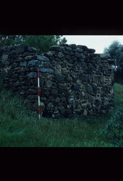
About 10 metres to the east is a smaller outbuilding - perhaps a barn, stable or dairy - which is terraced into the slope and whose walls, unusually, are nearly completely intact. Between the outbuilding and the house is a rock-cut well (1.8m in diameter), partly lined with corrugated metal. Approximately 25 metres to the north is a small stone retaining wall, which may have formed part of a large outbuilding or stockyard with a cobbled floor. A possible metalled access track extends to the north west past a c100 metre length of deteriorated stone wall, possibly that which has been on the site since about 1860. A large fig tree survives in front of the house, and a few growths of aloe and prickly pear are remnants of this era of European occupation.
There is a small flat beside the creek which was once used for orchards, but which now contains only one large gum tree and quite thick native vegetation planted since the site became a part of the Organ Pipes Park. In the early 1970s the remains of posts for the swing bridge and of foundations of engines and pumps used to irrigate the orchard are recorded as having remained on the property (Moloney 2003). These were not sighted during the survey but may still survive.MILLBROOK HOMESTEAD RUIN - Archaeological Significance
Two bluestone outer walls extend this section another 3.5 m north, but there are walls missing that might have been the mud brick mentioned in oral records. Walls and a hearth within this north eastern extension are built with bricks which seem to be both handmade and machine (Hoffman) made, perhaps from very late in the 19th century. These may also have replaced an original mud part of the house.
Approximately 6 metres by 4 metres in size, it is more primitive in construction than the residence employing irregular stone, including porous field stone, and chips of stone that have been quarried somewhere locally. Its four walls are almost completely intact, approaching 3 m high at its west facade, and with an intact timber door lintel. The walls retain the last few traces of whitewash. As with the house, the different mortars are exposed and deteriorating, especially the silt formerly protected by lime mortar and render. The house and this outbuilding are connected by an extant brick spoon drain.
Owing to its Public ownership since 1972, and its remote location,there has been very little disturbancesince the house was demolished. Although the buildings will have further deteriorated, there is a high potential for archaeological deposits in and around them which will provide information concerning their date and function, and the activities conduccted within them.
MILLBROOK HOMESTEAD RUIN - Historical Significance
The site is of historical significance as being amongst the more intact of the early farmstead complexes in the area. Millbrook property is the only known building associated with the Tullamarine land syndicate.
The public ownership of the place and its association with the Organ Pipes Park enhances its potential for long-term protection and interpretation, and increases its significance relative to other ruins of this type and vintage.Heritage Inventory Description
MILLBROOK HOMESTEAD RUIN - Heritage Inventory Description
The site of a mid 19th century homestead facing Jacksons Creek. It includes a bluestone and brick house ruin, a barn ruin and a large brick well. Other features include a ruin likely to be a bluestone barn, a drain and access track.
-
-
-
-
-
SHEPHERD'S HUT (ORGAN PIPES NATIONAL PARK)
 Victorian Heritage Inventory
 -
GALLOWAY ARMS, ORGAN PIPES NATIONAL PARK
 Victorian Heritage Inventory
 -
Organ Pipes National Park
 National Trust
-
-


