Back to search results
CORIYULE ESTATE HISTORICAL SITE
CORIYULE ROAD AND MCDERMOTT ROAD DRYSDALE, GREATER GEELONG CITY
CORIYULE ESTATE HISTORICAL SITE
CORIYULE ROAD AND MCDERMOTT ROAD DRYSDALE, GREATER GEELONG CITY
All information on this page is maintained by Heritage Victoria.
Click below for their website and contact details.
Victorian Heritage Inventory
On this page:
Statement of Significance
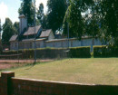
The "Coriyule Estate" shed and well are in a ruinous condition and are extant. There is little evidence surrounding the site to suggest that the orchard and treed boundary were once present. However the site is associated with an important property and early agriculture on the Bellarine Peninsula. Medium local significance.
What is significant?
How is it significant?
Why is it significant?
Show more
Show less
-
-
-
-
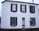
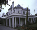
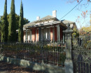
CORIYULE HOMESTEAD
 Victorian Heritage Register H0272
 -
"Coryule", homestead including interior
 Greater Geelong City H0272
 -
Coryule
 National Trust H0272
-
-