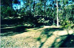
Lancashire Reef mines, dam and alluvial workings
CA 592C Maiden Gully Road, MAIDEN GULLY VIC 3551 - Property No 197868
-
Add to tour
You must log in to do that.
-
Share
-
Shortlist place
You must log in to do that.
- Download report


Statement of Significance
The site illustrates important aspects of both small-scale reef mining and hydraulic sluicing (criterion C) and is one of the best examples of mining undertaken on one of the minor lines of reef on Bendigo during the "big mine" phase between 1888 and 1914 (criterion A and criterion B).
-
-
Lancashire Reef mines, dam and alluvial workings - Physical Description 1
Lancashire Company
A small partially quarried mullock heap with two dumping lines, 25 metres long, situated just south of a track around the southern perimeter of the Council tip in Devonshire Gully. North of this heap there is a scatter of building stone and hand-made brick.
South Lancashire Company
South of the Lancashire mullock heap and on the opposite side of the gully there is another small mullock heap, with two short dumping lines. On the south side of the heap is a stone-edged quartz paddock.
Sluice-head dam - for sluicing of Armadale Gully
100 metres further south of the machinery site on the ridge between Maiden Gully and Devonshire Gully there is a well-preserved sluicing dam, fed by water races. The earthen wall of the dam has been faced with stone. The gully below the dam on the northern side has been sluiced.
Surface workings
Further south, on the fall into Maiden Gully, there is a line of shallow reef workings which extend for over 200 metres.
The mullock heaps are weathered and in some cases partially quarried; the dam, however, retains its definition and form. The integrity of the site is good, but reduced at the northern end by the multiplicity of tracks between the various sites.
Lancashire Reef mines, dam and alluvial workings - Physical Description 2
The eastern and western boundaries of the rectangular area of significance are 100 metres apart and equi-distant from a mean line with a true bearing of 340 degrees running through the intersecting centre lines of Albert Road and Maiden Gully Road. The southern boundary intersects this mean line at a point 150 metres north of this intersection point and the area of significance extends along the mean line for a further distance northwards of 600 metres.
Heritage Study and Grading
Greater Bendigo - Marong Heritage Study 1999
Author: Andrew Ward and Associates
Year: 1999
Grading: Local
-
-
-
-
-
DEVONSHIRE SAND DUMP
 Victorian Heritage Inventory
 -
LANCASHIRE REEF
 Victorian Heritage Inventory
 -
LANCASHIRE SLUICE HEAD
 Victorian Heritage Inventory
-
"1890"
 Yarra City
 -
'BRAESIDE'
 Boroondara City
 -
'ELAINE'
 Boroondara City
-
-


