CHINESE MARKET GARDENS
2605 BALLARAT-MARYBOROUGH ROAD TOURELLO, BALLARAT CITY

-
Add to tour
You must log in to do that.
-
Share
-
Shortlist place
You must log in to do that.
- Download report
Statement of Significance
-
-
CHINESE MARKET GARDENS - History
SiteCard data copied on 06/02/2025:In a letter dated 10 August 1853, John Hepburn described occupancy of the region by the Overlanders in early 1838 as follows: ‘I took up Smeaton Hill on the 15th of April 1838, having just been three months travelling. About ten days after, the Coghills took up their stations, Glendaruel and Glendonald; Harrison, who was too wise to be advised by me, came nearer the settlement, and took up a country I am not acquainted with, viz., the Plenty. After being some months on our respective stations that is Coghill and myself we found to the south of us the country about Buninyong taken up by Learmonth; the Leigh River by Yuille’ (Hepburn 1898, p. 54). Specifically, Hepburn described the location of the Glendonald (Coghill’s) run, where the potential historical site is now situated, as follows: ‘Glendaruel, Coghill's, and Dowling Forest, with Wynholm, have perhaps more prime land than any country of double the extent in this part of the country’ (Hepburn 1898, p. 63). Historical mapping, dating to around the 1840s, shows the borders of David Coghill’s Glendonald station as being adjacent to Donald Cameron’s station (Clunes) in the north, adjacent to William Campbell’s station (Tourello) in the northeast, the Birch brothers’ station (Seven Hills) in the southeast, William John Turner Clarke’s station (Dowling Forest) in the south, and across from William Coghill’s station (Glendaruel) along Creswick Creek in the west. This is confirmed by the description of the properties bounding Glendonald station, as described in The Argus (26 September 1848, p. 4). Captain William Coghill arrived in New South Wales from Scotland, purportedly on 27 October 1824, with two of his children, Ellen and George, aboard the Mangles. The ship was captained by his brother, Captain John Coghill. The rest of his family arrived in 1829, and the family lived on John’s land at Wingecarribee in NSW (Colonial Secretary 1828; Pentreath 2004; Stewart 2020a; 2020b). William had previously been granted 600 acres of land at Currockbilly in NSW, and appear to have subsequently moved to the property after the rest of William’s family arrived (New South Wales Government Gazette, 5 January 1838, p. 17). David Coghill, one of Captain William’s sons, applied for a 320-acre parcel of land adjacent to Currockbilly, but there is no record of this being granted (Stewart 2020a; 2020b). It is possible that this was one of the reasons that David, along with his father, Captain William, and brother, George, decided to drive sheep overland to the new grazing region in what is now Victoria. Travelling with Hepburn and the other overlanders, the Coghills, brought around 2,000 sheep to the region (Stewart 2020a; 2020b). Captain William Coghill is said to have persuaded Hepburn to take up land around Mount Beckworth, rather than Mount Kooroocheang (The Ballarat Courier, 23 January 1884, p. 2). Captain Coghill brought over the rest of his family, including his nephew William Coghill, after taking up land near Mount Beckworth (The Ballarat Courier, 23 January 1884, p. 2). David Coghill took up the Glendonald run, while William Coghill took up the adjacent Glendaruel run (it is unclear as to whether the ownership was granted to Captain William Coghill, or to his nephew, William Coghill). George Coghill (another of Captain William’s sons) took up the Lake Condon (Lake Condah) run in the Portland region (The Australasian, 14 November 1936, p. 4). William Coghill’s head station was situated southwest of Coghill’s Hill, adjacent to Tullaroop (or Deep) Creek (Figure 1 2). William and David’s runs were gazetted in October 1848, while George’s run was gazetted later in February 1849 (Spreadborough and Anderson 1983, pp. 114, 164). David Coghill did not hold the land for long after it was gazetted, transferring the Glendonald run to John Hepburn in January 1850 (Melbourne Daily News, 18 January 1850, p. 4). John Hepburn is shown to have owned the Glendonald Pre-emptive Right, to the east of the location where the Potential Chinese Market Gardens site is now situated, in mapping dated to 1859, confirming Coghill’s sale to Hepburn in January 1850. No features, other than that associated with the landform adjacent to the river, are noted within proximity to features of the Potential Chinese Market Gardens site. By the 1860s, the Glendonald run was subdivided into smaller rural allotments for sale. A total of 43 allotments within Sections 1 to 5 of the Parish of Tourello, adjacent to Hepburn’s Pre-Emptive Right in the west, were to be put up for auction on 17 May 1860 (The Argus 23 April 1860, p. 7). The features associated with the Potential Chinese Market Gardens site are located within what were allotments 4 and 5 of Section 3 of Tourello Parish, with Creswick Creek frontage in the west. Hepburn’s Pre-Emptive Right allotment is located across a roadway to the west of these allotments. A planned roadway is situated to the north of allotment 4, with a small rectangle of land over the creek (likely for a bridge) to the northwest of allotment 4. A water reserve is to the south of allotment 5. Other than the creek and its escarpments, there are no other features shown within either property. The 1866 mapping shows that allotment 4 was purchased by A Nicholson, and allotment 5 by T Austin. There is little information as to who T Austin was, or to his allotment, available on publicly available resources as of the writing of this background history. Alex Nicholson is recorded as having purchased allotment 3 of section 3 in Crown land sales during September 1864 (The Star, 24 September 1864, p. 4), which is confirmed by the 1866 mapping. This is situated across the creek/river to the west of the locations of the potential Chinese market garden features. According to The Ballarat Star (10 April 1868, p. 2), Nicholson, who had been a member of the Council of Ballarat Shire, died on 9 April after being thrown from his horse near Creswick. The Ballarat Star (29 April 1868, p. 2) stated that he grew wheat and oats on his farmland. After Nicholson’s death, both allotments 3 and 4 were put up for auction on 3 October 1868. Allotment 4 was described as being ‘fenced up, broken up, and improved’ (The Ballarat Star, 5 September 1868, p. 3). The fencing was described in The Ballarat Star as being substantial post and rail, with no major buildings noted on the allotment. Nicholson’s cottage and stable were situated on the adjacent allotment 3. Chinese workers are known to have been employed in the 1860s in the region, primarily at Bullarook, Ascot, Coghill’s Creek, and Mount Blowhard, although The Star (16 January 1864, p. 4) provides no details about where these labourers lived. There is no indication about which farmers in the region may have utilised their services, and the newspaper article only notes how they were paid for their work. The 1869 mapping refers to Hepburn’s Pre-Emptive Right allotment as Cattle Station Hill, but otherwise shows no features other than Creswick Creek (noted as Tullaroop Creek) as being within proximity to the features associated with the Potential Chinese Market Gardens. Parish mapping dating to 1878 shows little difference in the allotments, and only mentions the names of the original owners. No features are shown other than Creswick Creek and the roadways to the east and north of the allotments. Chinese workers in the region According to the 1861 census of Victoria, there were no Chinese people living at, or camping in, the Parish of Tourello at the time; there was only one Chinese person living within the municipality of Clunes in the Parish of Glendaruel in 1861 (Registrar General 1861). Similarly, the 1901 census of Victoria also lists no Chinese people as living in the Parish of Tourello; with only 12 Chinese people living in Clunes and eight in the Parish of Glendaruel in 1901 (Government Statist 1901), some 2 km to the west of the Potential Chinese Market Gardens site. The census records between 1861 and 1901 do not indicate how many Chinese people were living in Tourello. So, while it is possible that a market garden may have been established on the site prior to this date, the lack of historical evidence makes it unclear as to whether allotments 4 and/or 5 of section 3 of the Parish of Tourello once held a Chinese market garden. There was no Chinese mining camp at Clunes, the closest Chinese camp to Tourello being at what was then the Black Lead in Creswick during the 1850s, which is situated some 10 km to the southeast of the location of the potential features. This camp developed from an informal camp into a series of streets with small allotments with simple wooden structures, in the vicinity of today’s Calembeen Park. There were approximately 1,100 Chinese people living in the Creswick area in 1859, and nearly 2,000 by the early 1860s. This number dwindled to around 1,000 by the 1870s. The Chinese camp at Black Lead retained a stable population of approximately 400 individuals throughout this period. The camp not only housed miners, but also ‘merchants, tea shop proprietors, publicans, gamblers, pork butchers, market gardeners, hawkers, farm labourers, timber cutters, cartage contractors, joss house operators, and Chinese missionaries’ (Vines 2019). Pin Que, a local Chinese businessman, led a consortium which leased and operated the Grand Trunk Gold Mine (later called the Key Company Gold Mine) at Creswick, which was a major deep alluvial mine in the area. He appears to have contracted Chinese workers to work the deep lead mine (The Argus, 17 June 1873, p. 6). The number of Chinese people living in the Creswick region continued to dwindle from the 1880s into the 1890s, as goldmining endeavours declined. Those remaining turned to other occupations, such as growing vegetables. By the 1890s, the Chinese camp was becoming a shanty town after what appears to be years of neglect by the local Council in relation to poor drainage, and a lack of a footbridge to the camp (Vines 2019). Additional pressure came from the Creswick Proprietary Sluicing Company, who wished to have the camp condemned so they could mount operations on the Black Lead in the search for gold in 1900 (The Ballarat Star, 3 October 1900, p. 3). Eventually, the Black Lead Hydraulic Sluicing Company worked the area, dredging through alluvial deposits, followed by the Creswick Black Lead Hydraulic Sluicing Company in 1905 (Vines 2019). Due to this pressure by the mining companies on the Chinese camp, there were only 29 Chinese people recorded as residing in the Shire of Creswick by 1901 (Davies et al. 2015, p. 16). By 1909, the site of the ‘old Chinese Camp’ was sluiced out by the company, destroying the village, with the few remaining inhabitants having been paid some form of compensation for the loss (The Ballarat Star, 9 November 1908, p. 4; 19 February 1909, p. 6). Afterwards, the camp was reserved for a State School Plantation in the 1920s (Vines 2019). The Chinese people in the region were known to be adept water managers for both mining purposes and for market gardening, and were often employed to cut and repair races and dams at Creswick (Davies et al. 2015, p. 16). At least 30 Chinese men were known to have worked a garden in the Slaty Creek and Mopoke area (south of Creswick, in the Creswick forest) in the 1880s and 1890s, some 12 km from the potential Chinese market garden site, with some of the men known to live in huts with small patches of land up to one acre in size within the forest. The men would also fossick to supplement their income from gardening (Davies et al. 2015, p. 45; Vines 2019). As Chinese labourers were known to have worked farms across the region, with historical records noting Bullarook, Ascot, Coghill’s Creek and Mount Blowhard, they had knowledge of working the land in the region. However, there is little record as to who purchased either allotment 4 or 5 and combined the two into one, prior to the 1882 geological mapping of the area, or whether any Chinese people were employed at this location. Late 19th century occupation Mapping dated to 1882-1883 shows that there had been some changes made to the allotments on which the potential Chinese market garden features are situated, with allotments 4 and 5 having been amalgamated, along with the allotment immediately to the south of allotment 5. A small allotment appears to have been excised near the northeast corner of the larger property. The land within the property is described in the mapping as being a capping of rounded ferruginous gravel with occasional rounded quartz, especially on the fall towards the creek escarpment. This land is associated with the Newer Volcanic, while the land along the creek is Post Pliocene. There are no features indicated within the property on either map. Mapping of the Loddon and Avoca deep leads shows the original property boundaries, with their original allotment numbers. This map was likely based on the Parish maps for the area, and was not updated to show the most recent property boundaries, unlike the geological mapping. As with the other mapping of the area, there are no features, other than the creek itself and the roadways to the north and east, within proximity to the features associated with either allotment 4 or 5. Twentieth century occupation A review of the Certificates of Title for allotments 4 and 5 of section 3 of the Parish of Tourello (the location of the potential Chinese market garden features) have provided the following information on the occupation of the land during the early 20th century onwards. On 9 December 1932, Dorothy Helena Leishman, of Snizort at Clunes, became proprietor of allotments 3, 4, 5 and 11 of section 3, allotments 1, 2, 2A, 3, 3A, 4A, 4B, 4C, 4D, 5, 5A and 5B of section 4, and allotments 6C and part of 6A of section 7 of the Parish of Tourello on 9 December 1932 (volume 5829 folio 1165752). The properties were subsequently split between Arthur Graeme Leishman, also of Snizort, who acquired allotments 3, 4 and 5 of section 3 on 30 April 1942. This land transference is confirmed in his Certificate of Title (volume 6552 folio 1310311). The balance of Dorothy Leishman’s land went to Lauchlan Leishman on 17 May 1945. The Certificate of Title for allotments 3, 4 and 5 (volume 6552 folio 1310311) shows that Arthur Graeme Leishman of Strathalbyn and Andrew Leishman of Clunes subsequently became proprietors of the land as tenants in common on 30 January 1976. After Arthur Graeme Leishman’s death, his share of the land was granted to Ida Madge Leishman, who became a tenant in common with Andrew Leishman on 19 January 1981. The last members of the Leishman family to be tenants in common of the land were Stuart Ronald Leishman and Andrew Leishman, who became joint proprietors on 21 September 1994. The final entry on the Certificate of Title details that a company, Bradenthorpe Pty Ltd, became proprietor of the land on 1 February 1995. There are no details about this company available, other than it was an Australian Proprietary Company which was incorporated on 1 December 1994, and deregistered on 5 November 2017 (CreditorWatch 2024b). It appears to have been renamed as Old Bradenthorpe Pty Ltd when another company named Bradenthorpe Pty Ltd was registered on 29 May 2012 (CreditorWatch 2024a).CHINESE MARKET GARDENS - Interpretation of Site
According to the Policy for Determining Low Archaeological Value (Heritage Victoria 2018), for an archaeological site to have more than low archaeological value, and be approved for inclusion in the VHI, it must address both Threshold A (archaeology) and Threshold B (history). Modern aerial imagery has shown two features at the Potential Chinese Market Gardens site. These are parallel lines of formed stone, and a concentration of parallel striations across a river flat that appear commensurate with the form of garden beds. Although this has not been confirmed in the background history or the aerial and LiDAR imagery, the Potential Chinese Market Gardens is likely to have had dwellings and other structures (at the location of the ‘Historic mining camp’ as provided by the social pinpoint data) associated with the occupation and use of the site as a market garden. Due to the lack of development across the site, it is likely that archaeological evidence associated with these structures would still be present. Therefore, the Potential Chinese Market Gardens site meets Threshold A (archaeology). The Potential Chinese Market Gardens site gives us a rare physical example of an understanding of an agricultural system (a possible Chinese market garden) in the area outside of Creswick forest. The garden system is a rare local example in the Tourello area. Despite lack of documentary evidence for Chinese ownership or use of the property, Chinese market gardens are known to have been established adjacent to waterways near the township of Creswick, such as Creswick Creek, Slaty Creek and Mopoke Creek, which is only 10 km from the current site. While there are several Chinese market garden sites recorded to the south of Creswick, there are none recorded to the north of Creswick or within Tourello. Archaeological evidence, whether intact or in a degraded state, could provide details on how this Chinese garden was laid out and used, particularly the terracing seen in modern aerial imagery. Should this prove to be a Chinese market garden site, this would provide an opportunity to compare and contrast this site against the three recorded sites south/southeast of Creswick, Ah Young’s Gardens (VHI H7623-0336), Slaty Creek Chinese Garden and Sluicing Site (VHI H7623-0343), and the Back Creek Chinese Garden and Orchard (VHI H7623-0346), and provide a broader picture of small-scale Chinese market garden systems across the region; particularly as a possible Chinese market garden built on a site that was not associated with mining. Should this not prove to be Chinese in origin, it would provide valuable data on the relatively wide-scale use of terracing on the escarpment adjacent to Creswick Creek in an agricultural context, and provide an understanding as to the use of the features visible in the aerial imagery across the property near the creek. As such, the Potential Chinese Market Gardens meets Threshold B (history).
Heritage Inventory Description
CHINESE MARKET GARDENS - Heritage Inventory Description
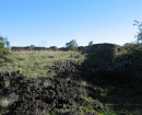
The features identified as potentially being associated with potential Chinese market gardens, ‘Terracing for historical Chinese market gardens’, ‘Historic mining camp’ and ‘Remnant stone walls’ (these tags being referred to as ‘Potential Chinese Market Gardens’ in this report) were identified from social pinpoint data as part of the Western Renewables Link project, and have not been verified through field survey due to land access constraints. There is no description provided in that dataset, other than the aforementioned tags provided in the social pinpoints. These three locations noted in the database are located on part of 2605 Ballarat-Maryborough Road, Tourello (4~3/PP3638, and 5~3/PP3638). The suggested locations of the features potentially related to Chinese market gardens are situated on what was once Glendonald station, originally owned by David Coghill, and later by John Hepburn. Aerial Imagery and LiDAR The social pinpoint data includes three location points for archaeological remains on this potential site. These are: remnant stone walls, an historic mining camp, and terracing for historic Chinese market gardens. No site access has been granted that would allow us to investigate these sites on the ground. However, with the use of aerial photography and LiDAR there are visible features in the location of two of the locations included in the social pinpoints: remnant stone walls, and the terracing for historic Chinese market gardens. Remnant Stone Walls Aerial photography distinctly shows three equally spaced parallel lines of stone of equal length running roughly in an east west direction, across the contours of a portion of higher ground above Creswick Creek, in the location provided in the social pinpoints for ‘Remnant stone walls’. These lines of stone are approximately 75 m long and are spaced at approximately 10 m -12 m apart. In addition to these distinct lines of stone, there is also the suggestion of another line 12 m to north and what appears to be another connecting them all together along their eastern edge. Unfortunately, the LiDAR image over these features is of low resolution and dark so no other disturbance around them is apparent. Terracing A series of regularly spaced striations are apparent in aerial imagery crossing the contours of a low relatively flat portion land at the northern end of the site on the bank of the Creswick Creek, in the location provided in the social pinpoints for ‘Terracing for historical Chinese market gardens’. Although these striations are apparent in the aerial photography, they initially appear as if they could be tracks possibly be made by sheep traversing the land. The LiDAR image here is much clearer, albeit still of a low resolution. The LiDAR image shows these to be roughly parallel and spaced approximately 7 m apart. They are also all roughly the same length (60-70 m). These striations are confined to a river flat that drops steeply away to the creek to its western side, rises steeply to a small escarpment that encloses the area to the north, east and south. In both the aerial image or the LiDAR the striations are shown to stop at the edge of the river flat before the ground drops away to the creek or rises to the escarpment. They do not continue up or along any of the slopes. That they are contained within a distinct geographical setting suggests that they are not tracks leading across the greater site, but appear as if they have been deliberately formed and were intended to be contained on the flat land. As these striations are located on relatively flat land, it is therefore clearly apparent from the aerial imagery that they are not terraces typically used on sloping land. However, their scale, form and location does suggest the possibility that they may have been formed as the beds and furrows that might be expected to be found on a market garden, or to perhaps control water flow in and around plantings, like swales. A second smaller concentration of striations is located 45 m to the north of the main concentration of striations. Although these appear less consistent in their length, direction and spacing, they are also located on the same river flat and do not extend towards the steeper ground. It is possible that these may also be associated with market garden activity. A third concentration of striations is also apparent on land on the northern side of the Creswick Creek, outside the subject site. These striations also run parallel to each other but they appear to be far more regimented than those the south. Although these are clearly apparent in the aerial imagery, they are less distinct in the LiDAR. However, unlike those to the south, they are located on the top of a small plateau that is also enclosed by a small escarpment. These striations might suggest that market garden activity may have extend across this landscape. However, the more regimented form and longer lines of this third concentration may be more likely the result of cropping and ploughing than gardening. Historic Mining Camp No visual evidence has been found in the aerial imagery or the LiDAR data that indicates the presence of an historic mining camp at the site. Furthermore, there is no recorded mining activity in the vicinity which would have supported the need for a mining camp. If there is any physical evidence on the ground, it would more likely be associated with the site of a market garden, given the presence of the other two features. The location of the ‘Historic mining camp’ may rather be the location of dwellings and other structures on the site associated with the occupation and use of the site as a market garden. Further site survey would be needed to confirm this, but there is potential given the other features. Comparative Chinese market garden sites Based on the background history of Chinese workers in the region, it is possible that individual or groups of Chinese men may have set up market gardens around the Creswick area, similar to that of Ah Young’s Gardens (VHI H7623-0336), Slaty Creek Chinese Garden and Sluicing Site (VHI H7623-0343), and the Back Creek Chinese Garden and Orchard (VHI H7623-0346). These are all situated within 20 km of the location of the features of the potential Chinese market garden. Ah Young’s Gardens (VHI H7623-0336) comprised terraced garden beds which had been hewn and levelled out and spread across a very rough and dry hillside, with garden beds and watering systems had to be fitted and levelled between major sluicing gullies. Slaty Creek Chinese Garden and Sluicing Site (VHI H7623-0343) had small ridged ‘beds’ which ran in various directions, both with and across the slope on which the garden was set, with water storage ponds and small channels between the ridged beds. The Back Creek Chinese Garden and Orchard (VHI H7623-0346) comprised small beds, channels and watering ponds on a good alluvial plain with a 2 m high earth bank near the northwest corner, which later had an orchard partially built over the site. These are three examples of at least 30 known small-scale market gardens owned by Chinese miners and market gardeners in the Creswick Creek (also known as Back Creek), Slaty Creek and Mopoke Creek areas to the south and southeast of Creswick) in the 1880s and 1890s (Davies et al. 2015, p. 15). Despite the lack of historical records, this activity and occupation may well have extended to the Parish of Tourello, some 5.6 km from Creswick, and the various features identified in aerial imagery at the Potential Chinese Market Gardens site. The Potential Chinese Market Gardens site intersects with an area of Aboriginal cultural heritage sensitivity associated with Creswick Creek. The site is also intersected by CHMP 18101.
-
-
-
-
-
ST KILDA PUBLIC LIBRARYVictorian Heritage Register H2456
-
RULES OF THE MELBOURNE FOOTBALL CLUBVictorian Heritage Register H2428
-
NORTH MELBOURNE POTTERYVictorian Heritage Inventory
-
-