Back to search results
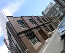
TANNERY (FORMER)
Old Tannery Road CAVENDISH, Southern Grampians Shire
TANNERY (FORMER)
Old Tannery Road CAVENDISH, Southern Grampians Shire
All information on this page is maintained by Southern Grampians Shire.
Click below for their website and contact details.
Southern Grampians Shire

23738 Copy of 4480 Tannery Old Tannery Rd Cavendish
On this page:
Statement of Significance
What is significant?
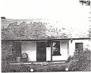
The former Tannery was located at the confluence of two creeks, about 2.5km south of Cavendish. It appears to date from at least 1850 and was certainly well-established by the early 1860s. Assistant Surveyor, Henry Wade allocated some 35 town allotments in the village which had developed up stream from the tannery with blocks being sold at least by 1864. It benefited from the availability of wattle bark and the supply and demand of leather goods. The tannery may have used the bark from indigenous wattle trees growing nearby or imported bark from the forests around Wando Dale, north of Coleraine. This was such an important and promising industry that a Royal Commission was established to enquire into its potential. The nearby Kenilworth South run had 5,000 head of cattle at the height of the tannery's operations. The tannery, which is one of only two or three in the Shire, appears to have closed by the end of the nineteenth century. The site is the least disturbed and retains the archaeological highest potential.
How is it significant?
The former Cavendish Tannery is of historical and archaeological significance to the community of Cavendish and the Southern Grampians Shire as a Heritage Inventory Site.
Why is it significant?
The former Cavendish Tannery is of historical significance because it represents a very early commercial activity associated with pastoralism and a way of life and work now lost.
The tannery is of archaeological significance as one of only three or four former tanneries identified in the study area and as the least disturbed site.
Show more
Show less
-
-
-
-
LONE GRAVES
 Southern Grampians Shire
 -
TANNERY (FORMER)
Southern Grampians Shire
-
"1890"
 Yarra City
 -
"AMF Officers" Shed
 Moorabool Shire
 -
"AQUA PROFONDA" SIGN, FITZROY POOL
 Victorian Heritage Register H1687
-
'CARINYA' LADSONS STORE
Victorian Heritage Register H0568
-
1 Alexander Street
Yarra City
-
1 Botherambo Street
Yarra City
-
-