CANNIBAL HILL OR MT. CANNIBAL
off Garfield North Road GARFIELD NORTH, Cardinia Shire
-
Add to tour
You must log in to do that.
-
Share
-
Shortlist place
You must log in to do that.
- Download report


Statement of Significance
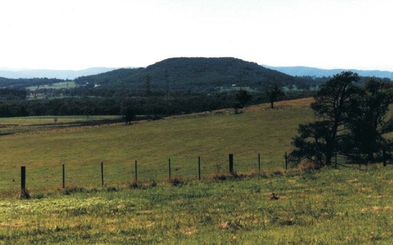
Cannibal Hill or Mt. Cannibal is of significance to the Cardinia Shire because it has associations with early exploration and pioneering surveys of the Shire. Cannibal Hill and Cannibal Creek are shown as important land marks on early maps such as an 1861 map showing the Gippsland Road(surveyed in 1847) crossing the creek. The hill retains native forest along the skyline but has been cleared at the base.
Cannibal Hill is also locally significant as an expression of the work of Shire Engineer, Ron Chambers, and the community to protect natural landscape within the Shire.
Regional Significance
-
-
CANNIBAL HILL OR MT. CANNIBAL - Physical Description 1
This distinctive flat-top (granite) landform can be seen from much further east on the former Sale Road (Princes Highway) and has been shown on early survey maps as a landmark to guide travellers. Today the mountain or hill retains the gum forest at its top (silver-leaf stringybark, white stringybark, messmate and mountain grey gum) but has been cleared lower down where a large house is now sited. Rock outcrops add to the distinction of this landform.
CANNIBAL HILL OR MT. CANNIBAL - Physical Conditions
The hill retains the native forest along the skyline but has been cleared at its base. The remnant forest has been identified a site of Regional Botanical Significance1.
Reference
1 Sue Harris cites Opie et.al. `Sites of Botanical Significance in the Westernport Region', 1984
CANNIBAL HILL OR MT. CANNIBAL - Historical Australian Themes
Theme - 2.3 Early district surveys
Heritage Study and Grading
Cardinia - Cardinia Shire Heritage Study 1996
Author: Graeme Butler & Associates
Year: 1996
Grading: Local
-
-
-
-
-
CANNIBAL HILL OR MT. CANNIBAL
 Cardinia Shire
-
-


