Keilor Market Gardens Cultural Landscape
Arundel Road and Milburn Road KEILOR, Brimbank City

-
Add to tour
You must log in to do that.
-
Share
-
Shortlist place
You must log in to do that.
- Download report


Statement of Significance
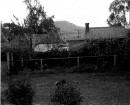
-
-
Keilor Market Gardens Cultural Landscape - Physical Description 1
The market garden cultural landscape covers a substantial area employing extensive irrigation systems and terracing. The irrigation systems are drawing on the Maribyrnong River, using pumps with both fixed and portable sprinkler systems. Terraces have been formed in levelling the fields with areas of steeply-sloping rough ground between. In some places the fields are divided by farm access tracks. The market garden area extends from Brimbank Park to near Overnewton Road, taking in only the alluvial terraces and centred on Arundel and Milburn Roads.
Most of the cultivated area is on the west bank of the Maribyrnong River, although smaller areas exist at Gumm's corner (no longer farmed, but once part of Borrell's farm) just opposite the Flora Street extension north of the freeway near Rio Vista Soils (also no longer farmed) and around Browns Road in the City of Hume. Another area of alluvial soil at the bottom of McNabs Road (also in the City of Hume) has also been cultivated. Immediately opposite the Brimbank proposed Cultural Landscape, are Heritage Overlay places in the City of Hume including HO255 Milburn's Weir, HO256 House (former Browns) Browns Road. Similarly, the Arundel Road Bridge, which is already included on the Victorian Heritage Register, straddles the municipal boundary.
The landscape is visually bounded by the top of the escarpment on the opposite side of the Maribyrnong to the north and east, by the Calder Freeway to the south and Overnewton College grounds to the west. As the municipal boundary follows the river, the escarpment and small areas of alluvial flat across the river are in the adjoining City of Hume. The landscape includes several places separately listed in the Brimbank Cultural Heritage Study including Milburn's Weir off Arundel Road Glenburn, The Grange, Hazelwood, and the Arundel Bridge.
The Site Number in the right hand column identifies places that are also individually listed in the Brimbank Heritage Study. The surviving houses that are contributory to the precinct include the following:
STREET Place DATE Contributory: Significance Level: Site Number
Arundel Road Keilor Market Gardens Cultural Landscape Heritage Area 1870s No Regional J
Arundel Road Frank Milburn's house 1900c. Yes Local 087
Arundel Road Grange Farm, David Milburn's 1868c. Yes Regional 033
Arundel Road Hazelwood, John Milburn's farmhouse 1892 c. Yes Regional 032
Arundel Road Milburn's Weir 1884 Yes State 013
Arundel Road Trestle Bridge Arundel Road Bridge 1906 Yes State 012Keilor Market Gardens Cultural Landscape - Physical Conditions
As a landscape the area is at a high level of integrity due to the very active horticultural industry now underway. However, few of the original homes of Farm Buildings survive, most having been replaced with modern brick veneer houses and steel framed machinery sheds.
Keilor Market Gardens Cultural Landscape - Historical Australian Themes
3 Developing local, regional and national economies
3.5 Developing primary productionHeritage Study and Grading
Brimbank - Brimbank City Council Post-contact Cultural Heritage Study
Author: G. Vines
Year: 2000
Grading: LocalBrimbank - Melbourne Western Region Industrial Heritage Study
Author: G. Vines & A. Ward
Year: 1989
Grading:
-
-
-
-
-
TRESTLE BRIDGEVictorian Heritage Register H1952
-
Arundel FarmNational Trust
-
Trestle BridgeNational Trust H1952
-
'Boonderoo', House and OutbuildingsGreater Bendigo City
-
'Riverslea' houseGreater Bendigo City
-
1 Adam StreetYarra City
-
-