ROYAL PARADE
ROYAL PARADE PARKVILLE AND ROYAL PARADE CARLTON NORTH AND ELIZABETH STREET MELBOURNE, MELBOURNE CITY
-
Add to tour
You must log in to do that.
-
Share
-
Shortlist place
You must log in to do that.
- Download report
Statement of Significance
What is significant
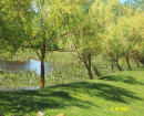
Royal Parade, the boulevard leading north out of Melbourne, runs between Park Street and Grattan Street in Parkville. A small section of Elizabeth Street from Grattan Street to the roundabout at Flemington Road is included as it completes the boulevard. The full width of carriageway and footpaths, comprising three roadway sections separated by four plantations with wide footpaths on either side make up the boulevard. The roadway accommodates a wide, two-way road and central two-way tramway with one-way service roads on either side. The two inner plantations comprise concrete-curbed, grassed medians planted with mature elms and two outer plantations consist of lines of mature elms planted in 1913 in the grass verges between the footpaths and road. The predominant species is English Elm (Ulmus procera) with approximately four hundred trees contributing to the park-like setting.
How is it significant
Royal Parade is of historical, aesthetic and social significance to the state of Victoria.
Why is it significant
Royal Parade is historically significant as "the road to Sydney" from the mid-nineteenth century and as Melbourne's traditional entrance from the north, re-emphasised in the early twentieth century by the introduction of the multiple elm avenue planted in 1913. It is also
historically significant as the multiple avenues demonstrate technical developments in the planning movement world-wide that led to the separation of fast and slow traffic, and different traffic types (motor vehicles and trams) by plantations that were both functional and beautiful.
Royal Parade is aesthetically significant as one of Victoria's finest boulevards. As Melbourne's main route to Sydney and northern Victoria, it was re-created in the early twentieth century as a major example of 'city beautiful' planning fashionable at the time. This was characterised by the multi-lane layout and the introduction of the four lines of English Elms. The profile, scale and seasonal change of the deciduous, multiple English Elm avenues provide shade in summer, autumn colour and sunlight penetration in winter.
-
-
ROYAL PARADE - History
HISTORY:
References:
Dr. Maxwell Lay, Melbourne Miles: The Story of Melbourne's Roads, Melbourne, Australian Scholarly Publishing Pty Ltd, 2003
Robert Freestone, Designing Australia's Cities: Culture, Commerce and the City Beautiful, 1900-1930, Sydney: University of NSW Press, 2007
Peter Yau and Bennie Hannah, Melbourne Boulevards - A Management Plan, City Of Melbourne, October 1992.
CONTEXTUAL HISTORY
Historically, along with the ring of parkland around the city area, Melbourne's boulevards are an outstanding landscape asset. Stretching out in various directions from the heart of the city, the boulevards have traditionally provided radial approaches with a strong landscape character. Royal Parade is one of the finest in Victoria.
HISTORY OF PLACE
Dr. Maxwell Lay, in Melbourne Miles: The Story of Melbourne's Roads, has noted that when Melbourne was first founded, overland travel to and from Sydney was quite rare. Travel by ship was preferred in terms of time, reliability and security. The route now known as Sydney Road and the Hume Highway was generally surveyed in 1838, but initially the preferred northern routes were via the tracks now known as Mickleham Road and Pascoe Vale Road. The present route had the virtue of being located between the Moonee Ponds and Merri Creeks, thus requiring no crossings and La Trobe's map of 1841 showed the route as the favoured way to Sydney. By 1855 it was established as the Sydney road. Although initially leading out of the city further to the east and curving round to the north, with land subdivision it came to be located along an appropriate adjacent section line which was also the town's north-south datum line from the high point of Batman's Hill through the signalling point on Flagstaff Hill.
According to Lay, the name Royal Parade began to be used as an alternative to Sydney Road for the section between Grattan Street and Brunswick Road in maps of 1898, but the name is generally attributed to the visit of the Duke of York, the future George V, to open Federal Parliament in May 1901.
By 1852 Carlton had been subdivided as far north as Grattan Street. Subdivision did not extend further until the early 1870s, due to Superintendent La Trobe's 'green belt' plan for the area, which allowed for the Melbourne cemetery, university and parkland including Royal Park and Princes Park. As a result of the deliberations of the Select Committee on Roads and Bridges leading to the 1853 Roads Act, a number of three and four chain radial road reservations were established on the recommendations of Robert Hoddle, the colony's assistant surveyor-general. These included Royal Parade, as well as St. Kilda Road, Wellington Parade, Hoddle Street (East Melbourne), Victoria Parade, Queens Parade and Flemington Road and Dandenong Road. Lay noted that unfortunately later subdivisions did not extend the reservations to the same width, and in particular in relation to Royal Parade where north of Brunswick Road, a one chain road, stretched almost 2000 kilometres of Australia waiting to be serviced by this narrow road.
In 1853 the Central Roads Board began the transformation of the Sydney road bullock track and stock route between the Elizabeth Street/Flemington Road junction and Park Street into a three-chain boulevard and lined its carriageways with pine trees. In 1913, there was much public dismay when the Melbourne City Council began removing the row of pine trees along the roadside and replacing them with the first of today's highly regarded elms. The work to the roadway in the 1910s was a necessary accompaniment to the extension of the tram service to the north from the inner city. Rockeries which separated the elms in the 1913 scheme were later removed as part of the Depression works project in the 1930s.
Housing construction on the boulevard's western side commenced in 1868 after land designated as parkland was sold for development. Building in north-western Royal Parade was tightly controlled by a Crown covenant that regulated the height, material and position of the houses. Development of the south-western aspect of the boulevard was not so controlled, and houses tended to be smaller and less grand. The south-west corner, initially the hay, corn and horse market, was taken over in the early twentieth century by the Royal Melbourne Hospital and University High School. After the 1870 covenant was annulled in 1972, larger residential buildings began to appear on the western side north of The Avenue, including university halls of residence. Development of the boulevard's eastern side has been confined to Princes Park and the University of Melbourne, apart from the Elizabeth Street section.
The early twentieth century tree-planting of Royal Parade was part of a wide-spread 'city beautiful' movement of the time. Robert Freestone in Designing Australia's Cities: Culture, Commerce and the City Beautiful 1900-1930, has pointed out that the idea of a tree-lined boulevard developed out of earlier garden elements such as allees and waterside promenades by the mid nineteenth century. Similarly technical developments in the planning movement world-wide had led to a scientific analysis and justification for landscaped, multi-lane street design, whereby fast and slow traffic should be separated, and motor vehicles from trams, by rows of trees and street gardens to absorb noise and dust. These ideas appealed both to modernist and civic art sensibilities. There was a belief that beautiful streets were not a luxury, but absolutely essential to the successful development of the 'city beautiful', and that to obtain the best results utility could not be forgotten.
The change to deciduous tree species for road avenues reflects this concern. Whereas earlier plantations such as the original conifers along the Sydney road, and the line of Blue Gums along St. Kilda Road had served an essentially functional purpose such as providing windbreaks and absorbing dust, the deciduous plantations of the early 20th century reflected the new concern with health and beauty. Deciduous trees provided badly needed shade in summer while allowing light and air during the winter months, and at the same time, providing the natural beauty afforded by the changing seasons. It had taken forty years for such ideas to resurface from the time they were first realised in the Finlay Avenue at Camperdown which was planted on 12 July 1876 by a Western District family, the Finlays, whose ideas derived from 18th century English parks and gardens.
Melbourne was at the forefront of the 'city beautiful' movement in the treatment of several of its major radial boulevards, including Royal Parade, the major elements of which are extant today. Royal Parade was declared a main road in 1995.
ROYAL PARADE - Plaque Citation
Originally the beginning of the road to Sydney, this is one of Victoria's finest boulevards, with four rows of English elms planted in 1913, and demonstrating 'city beautiful' planning ideals of the early twentieth century.
ROYAL PARADE - Permit Exemptions
General Exemptions:General exemptions apply to all places and objects included in the Victorian Heritage Register (VHR). General exemptions have been designed to allow everyday activities, maintenance and changes to your property, which don’t harm its cultural heritage significance, to proceed without the need to obtain approvals under the Heritage Act 2017.Places of worship: In some circumstances, you can alter a place of worship to accommodate religious practices without a permit, but you must notify the Executive Director of Heritage Victoria before you start the works or activities at least 20 business days before the works or activities are to commence.Subdivision/consolidation: Permit exemptions exist for some subdivisions and consolidations. If the subdivision or consolidation is in accordance with a planning permit granted under Part 4 of the Planning and Environment Act 1987 and the application for the planning permit was referred to the Executive Director of Heritage Victoria as a determining referral authority, a permit is not required.Specific exemptions may also apply to your registered place or object. If applicable, these are listed below. Specific exemptions are tailored to the conservation and management needs of an individual registered place or object and set out works and activities that are exempt from the requirements of a permit. Specific exemptions prevail if they conflict with general exemptions. Find out more about heritage permit exemptions here.Specific Exemptions:General Conditions: 1. All exempted alterations are to be planned and carried out in a manner which prevents damage to the fabric of the registered place or object.
General Conditions: 2. Should it become apparent during further inspection or the carrying out of alterations that original or previously hidden or inaccessible details of the place or object are revealed which relate to the significance of the place or object, then the exemption covering such alteration shall cease and the Executive Director shall be notified as soon as possible.
General Conditions: 3. If there is a conservation policy and plan approved by the Executive Director, all works shall be in accordance with it
General Conditions: 4. Nothing in this declaration prevents the Executive Director from amending or rescinding all or any of the permit exemptions.
General Conditions: 5. Nothing in this declaration exempts owners or their agents from the responsibility to seek relevant planning or building permits from the responsible authority where applicable.
Landscape:
* The process of gardening, mowing, hedge clipping, bedding displays, removal of dead plants, disease and weed control, emergency and safety works and landscaping in accordance with the original concept.
* In the event of loss or removal of trees, replanting with English Elms (Ulmus procera) to maintain the landscape character identified in the statement of significance.
* Management of trees in accordance with Australian Standard; Pruning of amenity trees AS 4373.
* Vegetation protection and management of the possum population.
* Removal of plants listed as Prohibited and Controlled Weeds in the Catchment and Land Protection Act 1994.
* Repairs, conservation and maintenance to hard landscape elements, memorial plaques, asphalt and gravel paths and roadways, stone and concrete edging, fences and gates.
* Installation, removal or replacement of garden watering and drainage systems beyond the canopy edge of listed trees.ROYAL PARADE - Permit Exemption Policy
The purpose of the exemptions is to allow works that do not affect the cultural heritage significance of the place.
The significance of Royal Parade is due to the width of the full carriage way which includes four grassed medians, concrete curbing, footpaths and consistent planting of four rows of English Elms. In managing changes to the boulevard planting, Melbourne Boulevards - A Management Plan by Peter Yau and Bennie Hannah, City Of Melbourne, October 1992 should be consulted.
-
-
-
-
-
CAMBRIDGE TERRACEVictorian Heritage Register H1606
-
TERRACEVictorian Heritage Register H0076
-
TERRACEVictorian Heritage Register H0078
-
DIGHTS MILL SITEVictorian Heritage Register H1522
-
DUNROESouthern Grampians Shire
-
EMU BOTTOMVictorian Heritage Register H0274
-
-