SALTWATER RIVER CROSSING SITE AND FOOTSCRAY WHARVES PRECINCT
MARIBYRNONG RIVER AND MORELAND STREET AND BUNBURY STREET AND WINGFIELD STREET AND NAPIER STREET AND HOPKINS STREET AND MARIBYRNONG STREET FOOTSCRAY, MARIBYRNONG CITY
-
Add to tour
You must log in to do that.
-
Share
-
Shortlist place
You must log in to do that.
- Download report
Statement of Significance
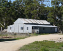
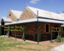
The Saltwater River Crossing site and Footscray wharves are located on the west bank of the Maribyrnong River, running south from Hopkins Street, Footscray. The site contains significant archaeological remains which have the capacity to demonstrate the sequence of development of the area in terms of the presence of public houses, residences and intensive industry. Included in the site are a number of significant above ground structures including the red brick construction associated with the Michaelis Hallenstein tannery operation, two bluestone cottages in Bunbury Street, the former Schwartz Boathouse and Henderson House.
The Saltwater River Crossing Site and Footscray Wharves are of historical, archaeological and social importance to the State of Victoria.
The Saltwater River Crossing site is historically important as it has a close association with the earliest stages of the history of Victoria, notably the 1803 visit of Acting Surveyor-General Charles Grimes. The site is also associated with the establishment of one of the early transport routes which connected Melbourne to regional areas, the road to Williamstown and Geelong, and with the subsequent westward expansion of Melbourne through the settlement and growth of the township of Footscray. The site illustrates the important historical role played by punt operators in the development of the Port Phillip Settlement and the integral relationship between the provision of transport facilities and the establishment of public houses. The Footscray wharves demonstrate the contributory importance of the Saltwater (Maribyrnong) River to the expansion of maritime transport and the development of industry. The Former Saltwater River Crossing site and Footscray wharves exhibit a remarkable range of cultural features representing the development of transport routes, the prominent role of public houses, the establishment of the township of Footscray, residential and industrial development, and maritime activity. The site also clearly illustrates the distinctive cultural landscape arising from the growth of industry and retains above ground structures which contribute to this landscape, notably Henderson House, the cottages in Bunbury Street, Schwartz's Boathouse and the original fabric of the Michaelis Hallenstein Tannery, visible as part of a recent brick recreational feature.
The Saltwater River Crossing site is archaeologically significant as it retains subsurface and above ground evidence of an event which in itself was to become uncommon, the establishment of a major punt crossing on the Yarra River with the subsequent growth of a hotel precinct. It is the site of one of only two major inner Melbourne archaeological investigations undertaken to date. The Former Saltwater River Crossing site is also rare as the archaeological evidence, together with the above ground structural remains, provides a comprehensive insight into the physical growth of one of Melbourne's early suburbs and its evolution into a major industrial site. The archaeological investigation of the site contributes to an understanding of the development and occupation of the area. Those features already excavated have the potential for public interpretation which would provide an outstanding illustration of both the historical significance of the site and the role of archaeology in expanding our knowledge and understanding of the history of Victoria. The site has acknowledged potential for further archaeological investigation which could provide further details relating to the occupation of the site and answer specific research questions. Further archaeological investigation of the Ship Inn site is of particular importance as it has the potential to provide an understanding of the sequential relationship of the various hotel sites. The combination of significant archaeological features (both land based and maritime) with above ground structures enhances the capacity for cultural heritage research and interpretation.
The Saltwater River Crossing site and Footscray wharves are socially important as they have a special association with the Footscray community as the site of the settlement of the Township of Footscray.
-
-
SALTWATER RIVER CROSSING SITE AND FOOTSCRAY WHARVES PRECINCT - History
Contextual History:
History of Place:
In the early years of the Melbourne settlement travellers heading west were forced to detour north around the area then referred to as Batman's Swamp. They could then cross the Saltwater (Maribyrnong) River at present day Avondale Heights. This crossing site marked the border of the tidal influence of the river. Early in 1839 the Port Phillip Gazette reported Police Magistrate William Lonsdale's proposal to establish a new line of road to Geelong and Williamstown which crossed the Saltwater River a little above its junction with the Yarra. This project was contingent on the establishment of a punt crossing at the site; a formal advertisement for the operation of the new punt appeared in the Port Phillip Patriot & Melbourne Advertiser on 27 March 1839 and Lonsdale soon established the punt for the benefit of travellers between Melbourne and Geelong and Williamstown (Lack, A History of Footscray, p.24). A map of the Parish of Cut- Pa Paw, dated 1848, shows the location of the punt on the road to Geelong (Parish of Cut Paw Paw, 1848, Historic Plans Collections, PROV).By the middle of 1839 the first mail cart was running between Melbourne and Geelong, utilising the new punt on the Saltwater River.
One consequence of the positioning of this punt was the establishment of a permanent settlement on the spot which, a decade later, was to become the township of Footscray. Although the first years of the Saltwater settlement were beset by problems - including floods, withholding of publican's licences, slow trade at the punt - the viability of the site was ensured by the advantages of location and available natural resources. The latter was to be of particular importance as the presence of water served the needs of the industries that would be later established on the river.
By the end of 1840, traffic along the Melbourne to Geelong road had increased noticeably and in December of that year the Geelong Advertiser published an account of the trip via the punt on the Saltwater River:
As it is likely that many persons may wish to visit Geelong this summer, an account of the road may be agreeable and useful to your readers. The distance between Melbourne and Geelong, is reckoned to be about 46 miles; Melbourne and the Punt, four miles; Punt to the River Ex, or Weerabee, fifteen miles; thence to the Little River, ten miles; and from the Little River to Geelong, eighteen miles.
J.P. Fawkner's 1841 Plan of the town of Melbourne showed a distinct track running across the swamp lagoon to the Punt, and south to Williamstown. (It is likely that Grimes Reserve incorporates a section of the original track from the punt to Williamstown and Geelong).Footscray village reserve was surveyed and named in 1848, bounded by Maribyrnong, Moreland, Whitehall and Cowper Streets and Wingfield and Bunbury streets (Lack, p.39).
In 1840 the Melbourne Racing Club moved its meetings from Batman's Hill to the Saltwater River Flats (today's Flemington Racecourse). The Melbourne City Council abattoirs were built at Flemington in 1860 and attracted new businesses along the Saltwater River in the form of tanners, couriers, hide merchants, fellmongers and tallowmelters. By the late 1860s Footscray had become the centre of the colonys meat preserving and meat-canning industry; by the 1870s the majority of Footscray's manufacturing workforce were employed in the meat preserving and noxious trades. Fishing was also a viable industry along that area of the river with several fishermen recorded as operating on the site.
By the mid 1870s, there were 122 feet (37 metres) of wharfage along the western side of the Saltwater River at Footscray ( Report of the Melbourne Harbor Trust Commissioners,1881, p. 27). When the Melbourne Harbour Trust was constituted to manage the Port of Melbourne in 1877, it assumed responsibility for the Saltwater River as far as Hopkins Street, Footscray. Finding that the 'small vessels using the Saltwater River were in want of wharfage accommodation' the Trust planned to extend the wharf northward from the existing wharf for a length of 600 feet (Report of the Melbourne Harbor Trust Commissioners , 1878, p.7). The Trust installed sheet piling along the western bank, filling in the area behind the sheet piling with silt and metalling the area to make it suitable for wharfage (Report of the Melbourne Harbor Trust Commissioners, 1879, p10). The following year contractors Carter and Dalgleish, extended the Footscray Town Wharf by 200 feet. Together with the sheet piling constructed in 1879, this lengthened the wharfage at Footscray to 922 feet (281 metres) by 1881(Report of the Melbourne Harbor Trust Commissioners,1881, p.27). The new extension to the Town Wharf was being used extensively for the shipment of cut stone from Footscray's quarries to Sydney (Report of the Melbourne Harbor Trust Commissioners,1881, p.11).
In 1883 a number of manufacturers of manures located along the river at Footscray ( including Binney, who had taken over Henderson's establishment in the early 1880s) petitioned the MHT to construct additional wharfage because they 'found it necessary in the prosecution of [their] business to have wharfage accommodation to a moderate extent'. They also requested that the Trust dredge the river at Footscray to a depth that would allow vessels drawing 11 feet of water to come alongside the wharf. The Trust agreed to construct the additional wharfage (1883, p. 28) In 1885 the Trust dredged a channel that was 100 feet (30.48 metres) wide, and 14 feet (4.2 metres) deep at low water. An 1892 plan of the Port of Melbourne indicated that the Footscray wharves stretched south from Hopkins Street as far as Parker Street. In 1917 a goods siding was constructed beside the wharf (Maribyrnong City Council Heritage Review, 2001, Vol.3, p. 117).
History of Place:
Although there appears to be no conclusive evidence, the site now named Grimes Reserve has received some support as being the place where Acting Surveyor-General Charles Grimes landed in 1803. The diarist in Grimes party, James Flemming, described the area in 1803 as follows:
The ground is a swamp on one side and high on the other. Saw many seals, pelicans and ducks.......the lagoon....is in a large swamp between the two rivers; fine grass, fit to mow; not a bush in it.....we took the left hand stream....The land became high where we landed and went on a hill.
The lagoon was the swampy area later to be known as Batman?s or the West Melbourne lagoon and swamp. The report that was finally prepared and submitted by Grimes, together with Flemming and Lieutenant Charles Robbins, provided a far from favourable account of the landscape and had the result of deferring the settlement of Port Phillip for a further 25 years.
Land survey and sales:
The area around the Saltwater River had been surveyed in December 1837 and January 1838. The Footscray Village Reserve was declared on one of the square mile sections of the grid and the Footscray Township Plan was drawn up in 1849. This plan placed the first punt at the foot of Bunbury Street. The five allotments south of Bunbury Street were sold on 12 September 1850. Eight of the ten allotments in the block between Wingfield and Bunbury Streets were sold in that same year; the remaining two were sold in 1852. Of the four allotments comprising the block between Hopkins and Wingfield Street, three sold in 1850 and the sale of the fourth was finalised in 1853. These first land holdings were to change considerably over the next 30 years through a process of sales, consolidation and subdivision.
The ensuing years are characterised by the history of the punt operations, the hotels, residential occupation and industrial development.
Punts and Hotels:
It is believed that the first puntman (1839), and hence probably the first resident of the settlement that was to become Footscray, was William Watts. Watts had previously operated a punt on the Yarra River. He applied unsuccessfully to open a public house on the Saltwater and it appears that the lack of success in the latter led him to also abandon the punt operation. Both the puntmen and the press at the time considered that punts and pubs would need to go hand in hand if the proprietors were to have any chance of operating a viable business.
A public house licence was eventually obtained by B.G. Levien, the next puntman on the Saltwater River.In October 1840 the Port Phillip Gazette reported that B.G. (Benjamin Goldsmid) Levien had recently obtained a licence to operate a Tavern - the Victoria Hotel - at his house at the Saltwater River and that he had also been granted permission to ply a punt. On the 15th of November 1840, Benjamin Levien advertised that his Victoria Hotel at the river crossing on the Saltwater River was opened. A new punt was also in the course of construction (Geelong Advertiser, 26 December 1840, p.4).
Levien and his wife Eliza appear to have been the first permanent settlers of the area - Levien took out the first pastoral lease, the first business licence near the river, cultivated the first land and built the first premises. It appears that by 1842 Levien had restricted his activity to the punt business as there is no reference to the operation of the Victoria Hotel after this date. The last reference to Levien's punting activity is his listing for Bourke County in 1845 as puntman, Saltwater river.
Levien's Hotel, on or near the corner of Bunbury and Maribyrnong Streets, was replaced by the Ship Inn, which, though delicensed in 1917, remained near the corner of Bunbury and Maribyrnong streets until it was demolished in 1970. By the late 1850s there were three hotels operating near the river crossing at Footscray - the Ship Inn, the Bridge and the Stanley Arms (Lack (ed) Charlie Lovett's Footscray, 1993, p5). The hotels not only serviced travellers, but also workers employed at boat and ship repair works in floating docks on the eastern side of the river opposite the Ship Inn in the 1850s and the river crossing at Footscray was described as a scene of 'bustle and activity' in the 1860s (Lack, 1993, p.6).
In September 1843 a new wine and beer licence for the Saltwater River, near the punt, was granted to William Crook. An 1844 reference refers to the new Bush Inn. By September of 1844 the licence had been transferred to another operator. Thomas Graham is reported as operating the Bush Inn and also as running a punt. It is unclear whether the Victoria Hotel and Bush Inn operated in competition but certainly the two punt operations were competitive. It is recorded that Graham had set up a punt for hire in the close vicinity of the one operated by Levien. The only clue to the possible location of the Bush Inn is that it was close to the Victoria Hotel.
Graham moved to Diamond Creek in 1846 and in 1847 the roll of both puntman and innkeeper at the Bush Inn (sometimes also referred to as the Punt Inn) had passed into the hands of a Mr Henry Kellett. Although Kellett remained the publican at the Bush Inn during the following year, the licence was held by the Pickett family. The Bush Inn is recorded as suffering severe damage from fire in 1848 and then being partially washed away in the floods of 1849. The major threat to the Saltwater River settlement - and the operation of its punts and pubs - during the 1840s was the persistent flooding which caused considerable damage to various establishments along the river and contributed to a turn-over of short lived ventures. The Pickett punt operation moved to a sight higher up the river in 1849 and the Saltwater River crossing site remained without a punt until 1855 at which time a punt was established at the site where present day Dynon Road crosses the river.
There is no evidence of a hotel on the site between the years 1849 and 1854. A new licence was granted in September 1854 to John Clark for the Stanley Arms Hotel and the licence application history is easily followed through to the 1870s. The Stanley Arms was also used as a morgue and inquest venue throughout the period.The Punt Inn (sometimes also referred to as the Punt Hotel) appears in the records again in 1855 when a licence was granted to James Maher. It is unclear however if this hotel is the same building that suffered fire/flood damage in 1848-49. In 1864 the name of the premises changes and is recorded as the Bridge Hotel with Mrs Leah Thorpe as the licensee (the name change refers to the Hopkins Street Bridge which was built in 1863). The licensee in 1866 was William Thompson who at the time was also running a fellmongery on adjacent land (see below under Industry). The hotel was two stories high, with a shallow cellar, and was built of brick, on stone foundations with a slate roof.
The first reference to the Ship Inn is in 1859 (in the Argus, 18 April 1860) with Peter Connelly recorded as the licensee. The licence was transferred to John Whitehead in 1860 and various changes of licensee are recorded through to the 1870s.
In the mid 1880s the Melbourne Harbour Trust issued a licence to operate a punt across the river from the foot of Bunbury Street to Thomas Cowell, the then licensee of the Ship Inn. The opening of several bridges across the river meant that this operation was short lived.
The Bridge Hotel was delicensed in 1931-2 and rented as a dwelling. It was purchased by Michaelis Hallenstein and Company in 1937 and leased to the Grenfell and later Ryan families as residence before being demolished in 1966-7. The Ship Inn was delicensed in 1919 and leased to a number of residential tenants. It was purchased by Australasian Steel Products in 1961 and subsequently demolished. The Stanley Arms Hotel was delicensed in 1920 and sold in 1926 to John Bell, whose factory was just south in Maribyrnong Street. It was used by the company as a storeroom from the early 1940s until it was demolished in the early 1960s.
Industry:
Slaughter houses, boiling down works and meat processing works were established on the other side of the river at Kensington from the 1840s (Lack, p. 34). Henderson's piggery (H0183) was constructed for Samuel Henderson in 1872- 1873. The complex of buildings included a factory for bacon and ham curing and a residence. Isaac Hallenstein purchased a tannery on the north side of Hopkins Street in 1864. After his uncle Moritz Michaelis joined him in business, the tannery site extended to the southern side of Hopkins Street, facing the river.
William Thompson's Fellmongery
The Sands and MacDougall directory lists Thompson's Fellmongery from 1872-76. Although the directories suggest that the fellmongery was sited off Maribyrnong Street, between Thompson's Bridge Hotel (he took over the licence in 1866) and Hopkins Street, he did not own this land. Rather, in 1872, he is recorded as purchasing the land that backed onto the Bridge Hotel from the west (not the north) which had frontages to Moreland and Wingfield Streets. John Lomax, a local tanner, is recorded as tenanting a substantial stone house on part of this allotment in the 1880s. The 1882-3 description of the site in the municipal valuation book is of a stone house (Lomax's) and fenced land, suggesting that Thompson's Fellmongery was a small and simple operation.
Louis Keppart, who had worked for Michaelis, Hallenstein and Co (below) from 1868-85, bought the Thompson Tannery site in 1882. He occupied the stone house from the mid 1880s and bought both the house and land from Margaret Thompson's executors in 1888. His tannery was apparently a small affair, consisting of a wooden structure with two rooms. The business was sold to Michaelis Hallenstein in 1919.
Michaelis Hallenstein and company
Isaac Hallenstein established a tannery to the north of Hopkins Street in 1864. He was joined in the business by a nephew, Moritz Michaelis and between them they created a successful business with branches in London, Sydney and New Zealand. In 1901 they purchased all the land north of Kepert's Tannery and the Bridge Hotel. They constructed a brick electric power plant in Maribyrnong Street, north of the Bridge Hotel but left the remainder of the site undeveloped until after the First World War. The company's fancy leather department is listed on the site from 1911 onwards, to the south of Hopkins Street. It is noted that Hallenstein's engineer also lived on the site in a large wooden house from around 1912. A 1906 description of the tannery refers to it as the largest in the southern hemisphere, occupying a site of upwards of 5 acres, nearly all of which was occupied by 'buildings of vast proportions'.
The company built a brick factory on the land north of Wingfield Street in the 1920s. In the 1930s they also constructed a large tannery on the same block. The business continued to operate into the 1980s, under different company ownership. The company closed operations and the entire site was transferred to the City of Footscray in 1984.
Samuel Henderson's Slaughterhouse, Ham and Bacon Curing Establishment
The best reference to this site is recorded in the municipal valuation books of the early 1880s, consisting of a large stone house, factory, two timber cottages and vacant land. Although Henderson had consolidated the site through a series of land purchases in the early 1870s (including the site of the Ship Inn) his ownership was for the very brief period of 1872 -3. He constructed a large brick and stone premises in 1872 and his Bacon and Ham Curing Establishment was described in the Williamstown chronicle of that year. The house, factory and stables are also illustrated in a c.1873 S.T. Gill lithograph. One of the cottages can be traced back to 1873 and it is possible that it pre-dated Henderson's purchase. Peter Langwill purchased the combined properties in 1873 but was forced to hand it over to creditors who resold early in the 1880s to John Blyth and Robert Binney. Binney occupied the stone house but let the factory to a wool merchant until the mid 1880s. From 1888-97 the factory was rented to a firm of coopers. The wooden cottages were rented to labourers. Blyth and Binney met with misfortune during the 1890 depression and the property passed to the national Trustees and Executors Agency in 1899. The wooden cottages appear to have not survived past this time; the stone house continued to be tenanted but the factory lay unused until 1901 at which time the Grapner family established a meat preserving works which continued through to the First World War.
The site was taken up by Swallow and Ariel immediately after the war and the bluestone house, stables, factory and remaining lands were purchased by the company in 1921. Swallow and Ariel occupied the site until it was sold in the late 1950s, at which time the bluestone house ceased to be used as a residence. The factory buildings and stables were demolished in 1969. The site, together with Henderson's bluestone house, was purchased by the city of Footscray in 1981. It is currently the Footscray Community Arts Centre. Henderson's House was placed on the Historic Buildings Register in 1974 and is classified by the National Trust.
Residences:
Margaret Pickett Cottages
Very few houses appear to have been constructed within the area during the early years of town formation in Footscray. A scattering of houses were constructed near the Bridge Hotel in Maribyrnong Street during the 1860s and 1870s, and in Moreland and Maribyrnong Streets to the north of the public reserve. William Picket purchased the two blocks along the southern side of Wingfield street in 1850 and in 1872 William Picket jnr sold both allotments to his widowed mother. Two houses were built on the Maribyrnong Street frontage of Allotment 8 in the mid 1870s by Margaret Picket. They were later owned by two prominent local councillor-businessmen, William Mitchell and David Newell. They were demolished in the 1897-98. Allotment 9, which had previously contained the Picket family home, is recorded as vacant land from 1882 until post First World War.
The Bunbury Street cottages & Schwartz Residence and Boathouse
Prior to the 1880s the site contained very few residences. The boom of the 1880s however led to increased land subdivision and house building. For the most part the new homes were timber built, single-storey detached houses on large allotments. Generally residences were confined to a Moreland Street pocket, running south from Bunbury Street. Until after the turn of the century the only structures north of the Stanley Arms Hotel were the Schwartz family home and boatshed off Bunbury and Maribyrnong Streets. Schwartz and his partner were contractors for the Melbourne Harbor Trust's 1890 wharfage expansion program. After his death the property was subdivided and sold, the boatshed being bought by the owner of the Stanley Arms Hotel. The boatshed was to later become a drill hall, then workshop for John R. Bell and Company. The former boatshed was not destroyed as part of the Ship Inn demolition and remains intact.
The large middle block between Wingfield and Bunbury Street remained vacant land through most of this period. In the mid 1880s a pair of stone row houses was built at the corner of Bunbury and Moreland streets. They were occupied by tenants until 1899 when they were bought by Louis Benjamin, the then Hallenstein?s tannery manager. He lived there until the 1920s. The industrial encroachment finally encompassed the cottages: the buildings have been incorporated into a factory complex, currently tenanted by Big Fish Workshop Pty Ltd.
The area went into decline in the interwar period. After the second world war most of the vacant allotments were filled with factories and workshops and families left for less offensive surroundings, renting their houses to poorer groups of labourers families. During this period all the hotels were delicensed. Both residences and hotels were gradually destroyed in a process of absorption into factories and businesses.
Footscray Wharves
One of the effects of increased activity on the Saltwater River was the abundance of shipping traffic utilising the river. The original Footscray Town Wharf was constructed along Maribyrnong Street, south of Napier Street, in the early 1870s. The volume of shipping peaked during the 1870s and the wharf needed to be expanded. By 1876 there were around 28 jetties between Hopkins Street and the river junction. The wharfage accommodation alongside Maribyrnong Street was finally extended by the Melbourne Harbor Trust in 1878-9. By 1880 there were 920 feet of wharves at Footscray. Additional wharves were built in 1889-90 but the shallowness of the river and low prioritisation by the Harbor Trust led to a decline in shipping activity. By 1910 the wharfage had decreased to only 700 feet.
The significance of the site plummeted after the First World War so that 'economically, the riverbank became a place of memories rather than activities' and the Maribyrnong became 'the place where old ships went to die'.
In the late 1920s a railway goods line was built across the river and intruded through the old subdivisions beneath Bunbury Street. A goods siding was subsequently built along Maribyrnong Street to service industries along the wharves. The entire area came to be more and more dominated by industry so that both the hotels and local housing stock diminished, deteriorated and either vanished or became absorbed by the surrounding local industrial precinct.
Archaeological Investigation
In 1989 an archaeological investigation of the City Link site was undertaken. This investigation followed on from the Heritage Study which had served to establish a detailed history of European settlement in the area and identify places of historical significance. The objectives of the archaeological project were to further interrogate the significance of the area through the investigation of specific sites: the Bridge Hotel, Stanley Arms Hotel, and the Pickett Cottages. The following summary is based on information contained in the excavation report (ref: Wilson, A. 1989, Archaeological Investigations of the City Link Development Site 1989.)
Bridge Hotel Site
No part of the superstructure of the building survived its demolition in 1966. The excavated remains comprised the foundations of the building and stone floor support walls which indicated the ground floor configuration of the hotel. The excavation revealed that the foundations of the building had been formed using a normal 'rubble fill' method but that the manner of construction varied from what would have been considered standard practice: rather than sinking trenches for the foundations and cellar the construction method was a process of structural levelling by building-up, followed by the deposition of a considerable amount of fill around the resulting raised structure. As a result the level of Maribyrnong Street was raised to meet the constructed doorways.
The excavation recovered artefact material from several deposits which provided evidence of the day-to-day activities of residents and workers at the hotel. These included a significant proportion of bottle glass, numerous types of tablewares (plates, bowls and cups), animal bones, and miscellaneous items such as clay tobacco pipes, buttons and marbles. This material has been analysed to provide a further insight into the lifestyles of occupants of the hotel: for example, an analysis of the bones from the major food animals found in the deposit layer relating to the 1895-1966 occupation period indicated that a high proportion of the remains were from better quality cuts and joints. This pattern reflects the growth of the Footscray township as a service and retail centre. Overall the investigation of the Bridge Hotel site provided a strong impression of continuous occupation of the building over more than a century.
The Stanley Arms Hotel Site
While this investigation was undertaken to study the remains of the hotel which was known to occupy the site from 1854 onwards it became evident that two different buildings had been established on the site. While the earlier structure was accepted as being the Stanley Arms, the later appeared to relate to the establishment of the original punt and the origins of the township of Footscray. The conclusion reached by the excavators of the site was that the earlier structure was the 1839 wooden building originally used by Levien as his house, and soon after licenced as the Victoria Hotel. This would be consistent with the siting of the building at the point where the road to Williamstown and Geelong turns away from the river bank - an ideal position to attract passing trade
The archaeological evidence of the 1839 structure indicated a wooden framed building 7 x 9 metres, built on a substantial unquarried bluestone plinth and divided in half along its north-south axis and unevenly along its east-west axis. It was apparent that the building was constructed two rooms deep, which was not the standard form for a residence. This suggests that its ultimate use as an inn had been planned from the time of its construction.
The excavation revealed that the original building had undergone two stages of extension, and that the original structure was rebuilt in samel brick, probably subsequent to the purchase of the building by John Clarke in 1850. An eastern extension (added to the front of the building) was the first use in the building of machine made bricks; it also conformed to the rubble fill method utilised in the other buildings investigated at the site. In the final stage of construction of the main building (c. 1866) new walls on quarried bluestone were built one metre outside the original northern and southern walls.
A considerable amount of artefact material was recovered from the site. Once again an analysis of the distribution of the animal bones contributed to an understanding of social patterns and lifestyles: the absence of rabbit bones in the earlier deposits, and abundance in the later deposits, is significant in its reflection of the introduction of rabbits into Victoria in 1859 and their increase in number to plague proportions within the next decade. The absence of identifiable pig bones from the earlier deposit also has important implications as Benjamin Levien identified himself and his family as Jews in the 1841 census - the scarcity of pig bones may be direct reflection of the lifestyle of the Levien family. In this case the archaeological record is able to provide evidence that can indicate possible religious practice, in this case the proscription of pork. The large number of early glass bottles also serves to support the proposition that the early structure was a hotel, and not a normal residence.
The Pickett Cottages Site
No part of the superstructure of the cottages survived the demolition in 1898. Excavation revealed foundations of quarried bluestone formed using the normal rubble fill method. There was relatively little evidence of every day activities, a reflection of the relatively short period of time during which the cottages were occupied. Cups, plates and platters were represented in small numbers, as were clay smoking pipes. A number of animal bones were also recovered. The complete absence of small items which commonly fall through fall boards suggests that the floor was completely sealed, probably constructed using tongue in groove floor boards.
The project involved ongoing consultation between the archaeologists and historians. As a result new questions could be addressed as they arose and new avenues of inquiry initiated.
COMPARISON:
There is no other site currently known within Victoria which retains such a comprehensive set of known archaeological material which relates to this stage of Melbourne's development and which particularly illustrates the close interlinking between the development of transport routes and public houses. While a major excavation was held at the Commonwealth Centre site in Little Lonsdale Street in 1988 the information obtained related more specifically to a substantially domestic urban site. This site has since been redeveloped.
There are no archaeological sites currently on the Heritage Register which relate to the development of inner suburban Melbourne or which are represented primarily by material relating to public houses and inns.Sources:
Melbourne Harbor Trust Commissioners Annual Reports
John Lack, A History of Footscray, Hargreen, North Melbourne, 1991
John Lack (ed), Charlie Lovett's Footscray, City of Footscray Historical Society, 1993
Jill Barnard, Graeme Butler, Francine Gilfedder and Gary Vines, Maroiubyrnong City Council Heritage Review, 2000.
SALTWATER RIVER CROSSING SITE AND FOOTSCRAY WHARVES PRECINCT - Permit Exemptions
General Exemptions:General exemptions apply to all places and objects included in the Victorian Heritage Register (VHR). General exemptions have been designed to allow everyday activities, maintenance and changes to your property, which don’t harm its cultural heritage significance, to proceed without the need to obtain approvals under the Heritage Act 2017.Places of worship: In some circumstances, you can alter a place of worship to accommodate religious practices without a permit, but you must notify the Executive Director of Heritage Victoria before you start the works or activities at least 20 business days before the works or activities are to commence.Subdivision/consolidation: Permit exemptions exist for some subdivisions and consolidations. If the subdivision or consolidation is in accordance with a planning permit granted under Part 4 of the Planning and Environment Act 1987 and the application for the planning permit was referred to the Executive Director of Heritage Victoria as a determining referral authority, a permit is not required.Specific exemptions may also apply to your registered place or object. If applicable, these are listed below. Specific exemptions are tailored to the conservation and management needs of an individual registered place or object and set out works and activities that are exempt from the requirements of a permit. Specific exemptions prevail if they conflict with general exemptions. Find out more about heritage permit exemptions here.Specific Exemptions:EXEMPTIONS FROM PERMITS:
(Classes of works or activities which may be undertaken without a permit under Part 4 of the Heritage Act 1995)
Policy:
The area is known to retain significant archaeological features, some of which have already been excavated and backfilled while others are yet to be investigated. As much as possible of the material at the known sites should be retained. In the event of any proposed subsurface disturbance of those areas identified as having archaeological sensitivity, either a preliminary archaeological excavation or a watching brief should be undertaken. In the event of significant subsurface remains being discovered in either of these
processes then it may be necessary to undertake a more substantial archaeological excavation. All attempts should be made to retain and conserve any further subsurface material in situ and, where appropriate, to provide appropriate interpretation of the material.
General Conditions:
All exempted alterations are to be planned and carried out in a manner which prevents damage to the fabric of the registered place or object. Should it become apparent during further inspection or the carrying out of alterations that original or previously hidden or inaccessible details of the place or object are revealed which relate to the significance of the place or object, then the exemption covering such alteration shall cease and the Executive Director shall be notified as soon as possible. If there is a conservation policy and plan approved by the Executive Director, all works shall be in accordance with it. Nothing in this declaration prevents the Executive Director from amending or rescinding all or any of the permit exemptions. Nothing in this declaration exempts owners or their agents from the responsibility to seek relevant planning or building permits from the responsible authority where applicable.
Exemptions
All internal works to the two cottages, 10-12 Bunbury Street. Regular maintenance works to the wharves
No archaeological monitoring or prior excavation work is needed for subsurface works in the following areas:
the western portion of the land marked L2 on Plan 602193 and included in Certificate of Title Volume 9867 Folio 806 which is bounded by Wingfield Street and Moreland Street and extends 50 metres in an easterly direction from the western end of Moreland Street
the portion of land in the south west corner of the land marked L2 on Plan 602193 which is bounded by Moreland and Bunbury Streets and extends 40 metres from the southern end of Moreland Street and 85 metres from the western end of Bunbury Street which more specifically is contained in Certificates of Title Volume 4221 Folio 161, Volume 4221 Folio 161, Volume 8058 Folio 980, Volume 4664 Folio 758, Volume 7231 Folio 048, Volume 8131 Folio 757, and Volume 3841 Folio 028.
-
-
-
-
-
FOOTSCRAY RAILWAY STATION COMPLEXVictorian Heritage Register H1563
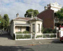
-
HENDERSON HOUSEVictorian Heritage Register H0183
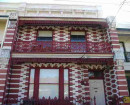
-
ERCILDOUNEVictorian Heritage Register H0494
-
3 Sherwood StreetYarra City
-
Archaeological siteSouthern Grampians Shire
-
BLACKWOOD HOMESTEAD COMPLEX AND CEMETERYSouthern Grampians Shire
-
-