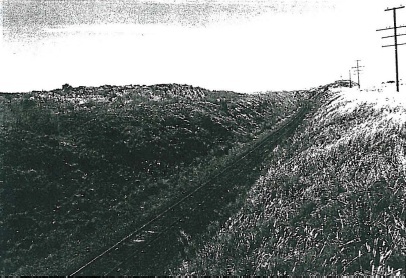
Ingliston Bank railway cutting and piles of remnant railway cutting construction basalt
Ironbark Road ROWSLEY, MOORABOOL SHIRE
-
Add to tour
You must log in to do that.
-
Share
-
Shortlist place
You must log in to do that.
- Download report

Statement of Significance
Massive spoil heaps of basalt excavated from the Melbourne - Ballarat railway cutting when it was constructed in 1887-89. These heaps are of regional historical significance, as evidence demonstrating an action of the government in developing the line. They are also of local architectural significance as indications of the extraordinary engineering achievement the excavation the line necessitated. They are of scientific significance for their archaeological research potential.
-
-
Ingliston Bank railway cutting and piles of remnant railway cutting construction basalt - Intactness
The spoil heaps and cuttings do not appear to have been disturbed.
Ingliston Bank railway cutting and piles of remnant railway cutting construction basalt - Physical Description 1
The railway construction works for elevating the Ballarat line to the top of the Pentland hills comprises an earth embankment on a 1800 curve at Rowsley with a steel trestle bridge over the Bacchus Marsh-Balliang Road. The line runs into a cutting at the Pages Lane crossing and then crosses Dogtrap Gully on a high embankment before plunging into a deep cutting near Dogtrap Gully Road, where it turns westward. The line continues in a deep cutting for three more kilometres after which it runs a ground level to the two crossings of Ironbark Road, the first at grade, and the second on a steel trestle bridge over the road. The remainder of the line to Inglistone is generally at grade, with three or four small cuttings.
A prominent feature of the route are the massive spoil dumps of basalt from the cutting excavations piled on both sides of the railway line, over a distance of 1.75km. The Goroke trigonometric point is on top of the highest point, demonstrating its prominence in the local landscape. The spoil heaps still show clearly the formations of the horse tramways and wheelbarrow runs which were used to move the spoil. Other small level areas may indicate shed and accommodation for the hundreds of navvies employed on the work. Between the railway line service road and Ironbark Road, south of the Werribee Gorge is Red Ironbark remnant Eucalyptus sideroxylon vegetation. (For location plan, refer: 47) .
Ingliston Bank railway cutting and piles of remnant railway cutting construction basalt - Historical Australian Themes
Transpa11,
Heritage Study and Grading
Moorabool - Bacchus Marsh Heritage Study 1995
Author: Richard Peterson and Daniel Catrice
Year: 1995
Grading:
-
-
-
-
-
'Lawn House' (Former)
 Hobsons Bay City
 -
1 Fairchild Street
 Yarra City
 -
10 Richardson Street
 Yarra City
-
-


