WARRNAMBOOL BREAKWATER, VIADUCT AND HARBOUR
BREAKWATER ROAD WARRNAMBOOL, WARRNAMBOOL CITY
-
Add to tour
You must log in to do that.
-
Share
-
Shortlist place
You must log in to do that.
- Download report
Statement of Significance
What is significant?
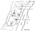
The Warrnambool Breakwater was designed by the eminent British harbour engineer Sir John Coode in 1879 and constructed between 1884 and 1890. Warrnambool was the centre of a prosperous farming region from the 1840s, and following the construction of jetties in the 1850s the harbour was extensively used and was a regular stop on the coastal steamer route. A plan was approved by the Government in 1874 to provide protection to shipping by constructing a breakwater, at an estimated cost of £110,000, but work stopped in 1877 after only £30,000 of this had been spent. In 1879 the Government commissioned Coode, who had been brought to Victoria by the Melbourne Harbour Trust to advise on works to improve the Port of Melbourne, to present a plan for completing the breakwater at Warrnambool. His original proposal was considered too expensive, and he presented a revised plan for a shorter structure to cost an estimated £134,000, consisting of a timber viaduct leading from the shore out to a 900 feet long concrete breakwater and wharf. In 1884 a tender was accepted for the approach works to the viaduct, to cost £27,173, and in 1885 a contract for £129,017 was accepted from Arthur Dobson for the remaining works. The work was completed in 1890, but the structure soon proved to be too short to give good protection from weather from the south-east or to allow berthage for larger vessels. Rather than trade through the port increasing after the completion of the breakwater, it fell, largely because of competition from the just-completed railway line. It was also apparent that the breakwater was causing siltation in the harbour, which by 1910 required continuous dredging. In 1914 a contract was let for £70,000 to extend the breakwater by about 300 ft, but this work was a failure and the new structure soon began to subside. By the 1920s about two-thirds of the original harbour was silted up. An attempt was made in the 1920s to reduce siltation by sheeting the viaduct, but this only increased the problem. By the 1940s the harbour was no longer used. During the 1950s and 1960s the viaduct was altered again, with the base enclosed and filled with basalt and the road on top re-levelled.
The Warrnambool Breakwater consists of two parts: the concrete breakwater extending out into the bay, and the timber viaduct which once joined it to the shore, which now runs along the east side of the Merri River and is surrounded by land to the east. The breakwater is 30ft wide with a 15 ft wide parapet with a walkway along the top. It is made up of a base of 32 ton concrete blocks with mass concrete above the waterline. The viaduct was originally a raised timber structure, but is now filled in below and to the sides with bluestone rubble, and there is an asphalt roadway, known as Viaduct Road, laid along the top. The area to the east of the viaduct which was once part of the harbour is now land, and a car park has been constructed along the new shoreline. The breakwater railway was removed in 1962, though some remnants of rail remain, and all buildings once associated with the breakwater have also been removed.
How is it significant?
The Warrnambool Breakwater is of historical significance to the state of Victoria.
Why is it significant?
The Warrnambool Breakwater is of historical significance as one of the most important maritime engineering projects in Victoria in the late nineteenth century. It is evidence of Victoria's nineteenth century investment in regional port infrastructure and the development of Victorian coastal shipping. It is of significance for its association with the English civil engineer Sir John Coode, the most distinguished harbour engineer of the nineteenth century, who was brought to Victoria to advise on works to improve the Port of Melbourne, but was retained by the Government to advise on improvements to the harbours at Portland, Geelong, Port Fairy, and Lakes Entrance, as well as Warrnambool. His projects for Melbourne, Lakes Entrance and Warrnambool were major engineering projects of the nineteenth century. The breakwater is historically significant as a reminder of Warrnambool's early maritime history as a Western District port, and as one of Victoria's major 'outer ports'. While the Warrnambool Breakwater is a demonstration of the engineering skills of the nineteenth century, it also demonstrates the limitations of knowledge relating to sedimentology at the time and the confidence apparent in a number of nineteenth century plans which assumed that natural forces could be overcome or contained by engineering.
-
-
WARRNAMBOOL BREAKWATER, VIADUCT AND HARBOUR - History
CONTEXTUAL HISTORY
Maritime infrastructure has played an important role in Victoria's economic development, and vast amounts of money were expended in the nineteenth century on improving port facilities. Until the development of the railways in the late nineteenth century and of motor transport in the early twentieth century, sea transport was generally easier and cheaper than by land.
While Melbourne, and to a lesser extent Geelong, have always been by far the most important ports, the so-called 'outer ports' were essential for development of the other parts of the colony. The major outer ports were Portland, Port Fairy, Warrnambool, Western Port, Corner Inlet and the Gippsland Lakes. The minor ports were Port Campbell, Apollo Bay, Lorne, Inverloch and Waratah Bay (G Kermode, 'The Outer Ports of Victoria', in 'One Hundred years of Engineering in Victoria', Journal of the Institution of Engineers Australia, October 1934, pp 374-6).
According to Jill Barnard ('Sea and River Transport. A Thematic Survey', for Historic Places Section, DRE), Portland, Port Fairy and Warrnambool lost out to the central ports partly because of inadequacy of the harbour improvements made in the nineteenth century.
Countless studies and chartings of each of these harbours urged various methods to improve the safety and berth space at each of these ports and engineering improvements in the form of jetties and training walls seemed never to adequately solve problems. Jetties were built in wrong positions, or in too shallow water to cater for increasingly large ships, training walls and breakwaters caused scouring or siltation. While the Port of Melbourne had the Melbourne Harbour Trust (later Port of Melbourne Authority) from 1876, which transformed the port facilities with the creation for the Coode Canal, the creation of docklands at West Melbourne and the addition of piers at Williamstown and Port Melbourne, other ports relied on money from the government to improve facilities.
The construction of the rail network in the late nineteenth century was also a problem for the outer ports, as this converged on Melbourne from all parts of the state, and the cheaper freight rates offered by the railways encouraged primary producers toward rail transport and away from the ports.
Sir John Coode (1816-1892)
[information from D R Crawford, 'Coode, Sir John (1816-1892) in Australian Dictionary of Biography - online edition.]
Sir John Coode was an English civil engineer, said to be 'probably the most distinguished harbour engineer of the nineteenth century'. As well as major works in Britain he designed the breakwater and docks at cape Town and Colombo, before his first visit to Australia 1878, when he was brought out by the Melbourne Harbour Trust to report on works for improving the port. Coode was then retained by the government to report on other harbours.
At Portland his recommendation to build a breakwater of 3450 feet (1052 metres) protecting several short shipping piers was considered too expensive and elaborate, and only a small, ineffective 'Fisherman's Breakwater' was constructed. A breakwater similar to Coode's proposal was finally built in 1960. At Geelong a bar running across the harbour mouth prevented large ships from entering: Coodes' recommendation of 1879 of a direct channel cut through the bar was adopted by the government. His recommendations for Warrnambool and Port Fairy were also carried out. His Lakes Entrance plan brought Gippsland into direct communication with the sea by the construction of a channel through the sand dunes between the lakes and the ocean. This work was completed in June 1889. In South Australia Coode reported on navigation of the Murray River mouth.
HISTORY OF PLACE
[Information largely taken from CE Sayers & P L Yule, By These we Flourish. A History of Warrnambool, Warrnambool 1987 [1969], Chapters 13 & 19.]
Pre-1874: jetties
The area around Warrnambool is high-producing farm land, and in the early days its produce was transported to markets not by road but by ship. However the port at Warrnambool, known as Lady Bay, was small, lacked loading facilities and had little natural protection. The local people felt that in comparison to the nearby ports of Portland and Port Fairy, and even more in comparison to Melbourne and Geelong, the port and town of Warrnambool were neglected by the authorities. The latter had the advantage of influential local citizens (the Henty family in Portland and William Rutledge in Port Fairy) to encourage investment in their port facilities. Nevertheless by the 1850s Warrnambool harbour was extensively used, and became a regular stop on the coastal steamer route from Port Phillip to the west coast ports and even in the triangle between the west coast, Port Phillip and Launceston.
There were dangers with Warrnambool harbour however, including treacherous reefs, shallow water, siltation problems and openness to the ocean, which resulted in several ships being wrecked in the harbour in the 1840s and 1850s.
The first jetty was built at Lady Bay in 1850 and a second in 1857. However trade was slow, and despite attempts by the locals to break the Henty hold on sea traffic with the formation in 1854 of the Western Steam Navigation Company Pty Ltd, this failed in 1856, and by 1862 the Hentys had control of the sea trade, which favoured Portland against the interests of Port Fairy and Warrnambool. The company reformed in 1868, with the aim of owning steamships which would trade direct to Warrnambool and keep regular trading schedules with its own steamships.
Early works
From 1870 to 1880 the building of a breakwater or wharf in Lady Bay was constantly being brought before the local and colonial government. In 1870 Council prepared plans to deepen part of the bay and build a breakwater, a wharf and a tramway (designed by the borough engineer Andrew Kerr) on the reef, but this was rejected. In 1872 a board of engineers appointed by the Francis government reported that breakwater should be built 600 yards in length at an estimated cost of £110,000. It noted that this 'could not be relied upon to secure smooth water in all weathers. The plan was approved in early 1874 and money was allocated for preliminary work, such as testing concrete blocks. The Government agreed to spend £30,000 on the work over three years. A contract was let for the first year's work, but little effective work was possible with only £10,000, and when this was used up operations stopped. During the following years there were frequent changes of government and while the second £10,000 was allocated, the third was opposed by the Berry Government, which thought that the previous grants had been money 'pitched in to the sea'. The previous £20,000 had been used to make a foundation for the intended breakwater, but the work was ineffective. The final instalment was paid in late 1877, but the government refused to provide more and work stopped.
The Coode breakwater1879-1890
The breakwater became a major political issue in the south-west. In 1879 the Government commissioned Sir John Coode, the most distinguished harbour engineer of the time, to make an inspection and present a plan for completing the work. Following an exhaustive survey of the bay in April 1879 he recommended the building of a combined 1800 feet [549 metres] long breakwater and wharf made of concrete blocks and connected with the shore, to cost £280,900. When the Government baulked at the cost, Coode came up with a revised plan: a solid breakwater 900 feet [274 metres] long with a viaduct from the shore to the breakwater, to cost an estimated £134,000.
In 1883 the Government agreed to make available £120,000, but it was not until 1884 that a tender was accepted for the construction of approaches to the proposed viaduct, at a cost of £27,173. In 1885 Coode passed this work as satisfactory, and a contract was accepted for £129,017 from Arthur Dudley Dobson, a competent engineer and shrewd businessman, for the completion of the main part of the plan. It provided for the breakwater to run out 1033 feet and be made of 32 ton concrete blocks with mass concrete above the waterline. It was to be 30 feet wide and a parapet 15 feet wide with a footway on top. It would allow three vessels to berth at the same time, in water 30-35 feet deep. The work was to be completed in three and a half years.
The giant concrete blocks were made nearby on Jetty Flat, stacked by means of a giant crane and taken to the breakwater site by another giant crane, both imported from England. The site had been dredged and bags of cement placed on top, and the blocks were placed on top of these. Despite problems with the weather, the job was completed by the end of 1890, within the contract time, and was considered to be first class in design, materials and workmanship.
The breakwater gave fair protection from weather from the south or south-west, but it was too short to give protection from weather from the south-east, or to allow berthage for larger ocean-going vessels. Local bodies began to agitate for an addition of 400 feet, the cost of which the town argued would be met by the increased port trade. The government however doubted that the addition would increase trade, and this was likely to be reduced further by the just completed railway connection. Their advisers reported against further work being done. William Telford Webb, the commissioner of Public Works (1893-4) was concerned already about the encroachment of sand on the harbourage, between the viaduct and the jetty to the east. He also considered that too much money had already been spent (at a time when Australia was in a depression) on harbours (£236,000 on the Warrnambool harbour works alone), which were now competing with the state-owned railways.
Influence of the breakwater on sedimentation
During the 1890s trade through the port continued to drop, due to the lower costs of rail transport and to increasing siltation caused by the breakwater. By 1905 the siltation was a danger to navigation and was damaging the reputation of the port. By 1910 exports from the port had fallen from 40,000 to 4,000 tons, and continuous dredging was needed to keep the harbour clear of sand.
The engineers of the day believed that the sand filtering into the bay came from the Merri River, and thought that the alteration of the flow of the river would prevent undue siltation. But the construction of the breakwater in fact had shut off the west to east currents which had in the past scoured the sand from the bay.
The 1914 extension
The Chief Engineer of the Public Works Department Carlo Catani proposed a plan, costed at £180,000, for building a dock and dredging to increase berthing accommodation. In 1912 the Murray Government told the council that this would not go ahead, as it was not fair to the other ports to spend so much on Warrnambool. Another scheme for improvements was announced, but was not carried out, and protective works were not attempted. In 1914 a contract was let for £70,000 for extending the breakwater about 300 feet, but the work was not satisfactory, and the new part of the pier began to subside. World War I interrupted any further attempts to improve matters, and in the immediate post-war years there was no money available for new works.
By the 1920s roughly two-thirds of the original harbour was no longer of any use to shipping. Large vessels would not enter Lady Bay and local products had increasingly been sent by rail to Portland for shipment, or directly to Geelong and Melbourne.
In 1923 a judicial inquiry was held into the failure of the 1914 works, and a Royal Commission was appointed to investigate the question of outer port development. The Royal Commission recommended the appointment of a series of local harbour trusts. The Warrnambool board's most positive work was the sheeting of the breakwater viaduct. It was thought that this would make the berthage area safer and minimise the need for dredging. However the sheeting had the opposite effect, aggravating siltation and reducing the depth of the harbour.
By the 1940s the only regular caller was a collier which called once a month but this ended in 1942. Between 1854 and 1977 siltation resulted in the addition of 11 acres of land to what had been the harbour.
The breakwater today
In 1907 access to the breakwater was by the viaduct over the water, but sand deposited around the piles has resulted in a natural reclamation of the land east of the viaduct. Alterations over the years include filling in of the open viaduct in c1925, and during the 1950s and 1960s it was altered again, with the base being enclosed and filled with basalt, and an asphalt road, known as Viaduct Road, constructed along the top. An extensive car park has been constructed along the present shoreline. The breakwater railway was largely removed in 1962, and all buildings associated with the breakwater have been removed.
WARRNAMBOOL BREAKWATER, VIADUCT AND HARBOUR - Assessment Against Criteria
a. Importance to the course, or pattern, of Victoria's cultural history
The Warrnambool Breakwater was one of the most important maritime engineering projects in Victoria in the late nineteenth century. It demonstrates Victoria's nineteenth century investment in regional port infrastructure and the development of Victorian coastal shipping. It is associated with the English civil engineer Sir John Coode, the most distinguished harbour engineer of the nineteenth century, who was brought to Victoria to advise on works to improve the Port of Melbourne, but was retained by the Government to advise on improvements to the harbours at Portland, Geelong, Port Fairy, and Lakes Entrance, as well as Warrnambool. His projects for Melbourne, Lakes Entrance and Warrnambool were major engineering projects of the nineteenth century. The breakwater is a reminder of Warrnambool's early maritime history as a Western District port, and as one of Victoria's major 'outer ports'. While the Warrnambool Breakwater is a demonstration of the engineering skills of the nineteenth century, it also demonstrates the limitations of knowledge relating to sedimentology at the time and of the confidence apparent in a number of nineteenth century plans which assumed that natural forces could be overcome or contained by engineering.
b. Possession of uncommon, rare or endangered aspects of Victoria's cultural history.
c. Potential to yield information that will contribute to an understanding of Victoria's cultural history.
d. Importance in demonstrating the principal characteristics of a class of cultural places or environments.
e. Importance in exhibiting particular aesthetic characteristics.
f. Importance in demonstrating a high degree of creative or technical achievement at a particular period.
g. Strong or special association with a particular community or cultural group for social, cultural or spiritual reasons. This includes the significance of a place to Indigenous peoples as part of their continuing and developing cultural traditions.
h. Special association with the life or works of a person, or group of persons, of importance in Victoria's history.
The Warrnambool Breakwater was a major Australian work of the English civil engineer Sir John Coode, the most distinguished harbour engineer of the nineteenth century.
WARRNAMBOOL BREAKWATER, VIADUCT AND HARBOUR - Plaque Citation
Designed by the eminent British harbour engineer Sir John Coode in 1879 and built between 1884 and 1890 this was one of Victoria's most important maritime engineering projects of the late nineteenth century.
WARRNAMBOOL BREAKWATER, VIADUCT AND HARBOUR - Permit Exemptions
General Exemptions:General exemptions apply to all places and objects included in the Victorian Heritage Register (VHR). General exemptions have been designed to allow everyday activities, maintenance and changes to your property, which don’t harm its cultural heritage significance, to proceed without the need to obtain approvals under the Heritage Act 2017.Places of worship: In some circumstances, you can alter a place of worship to accommodate religious practices without a permit, but you must notify the Executive Director of Heritage Victoria before you start the works or activities at least 20 business days before the works or activities are to commence.Subdivision/consolidation: Permit exemptions exist for some subdivisions and consolidations. If the subdivision or consolidation is in accordance with a planning permit granted under Part 4 of the Planning and Environment Act 1987 and the application for the planning permit was referred to the Executive Director of Heritage Victoria as a determining referral authority, a permit is not required.Specific exemptions may also apply to your registered place or object. If applicable, these are listed below. Specific exemptions are tailored to the conservation and management needs of an individual registered place or object and set out works and activities that are exempt from the requirements of a permit. Specific exemptions prevail if they conflict with general exemptions. Find out more about heritage permit exemptions here.Specific Exemptions:General Conditions: 1. All exempted alterations are to be planned and carried out in a manner which prevents damage to the fabric of the registered place or object. General Conditions: 2. Should it become apparent during further inspection or the carrying out of works that original or previously hidden or inaccessible details of the place or object are revealed which relate to the significance of the place or object, then the exemption covering such works shall cease and Heritage Victoria shall be notified as soon as possible. General Conditions: 3. If there is a conservation policy and plan endorsed by the Executive Director, all works shall be in accordance with it. Note: The existence of a Conservation Management Plan or a Heritage Action Plan endorsed by the Executive Director, Heritage Victoria provides guidance for the management of the heritage values associated with the site. It may not be necessary to obtain a heritage permit for certain works specified in the management plan. General Conditions: 4. Nothing in this determination prevents the Executive Director from amending or rescinding all or any of the permit exemptions. General Conditions: 5. Nothing in this determination exempts owners or their agents from the responsibility to seek relevant planning or building permits from the responsible authorities where applicable. Minor Works : Note: Any Minor Works that in the opinion of the Executive Director will not adversely affect the heritage significance of the place may be exempt from the permit requirements of the Heritage Act. A person proposing to undertake minor works may submit a proposal to the Executive Director. If the Executive Director is satisfied that the proposed works will not adversely affect the heritage values of the site, the applicant may be exempted from the requirement to obtain a heritage permit. If an applicant is uncertain whether a heritage permit is required, it is recommended that the permits co-ordinator be contacted.WARRNAMBOOL BREAKWATER, VIADUCT AND HARBOUR - Permit Exemption Policy
The purpose of the Permit Policy is to assist when considering or making decisions regarding works to the place. It is recommended that any proposed works be discussed with an officer of Heritage Victoria prior to a permit application. Discussing any proposed works will assist in answering any questions the owner may have and aid any decisions regarding works to the place. It is recommended that a Conservation Management Plan is undertaken to assist with the future management of the cultural significance of the place.
Any new building on the site may impact upon the cultural heritage significance of the place and requires a permit. The purpose of this requirement is not to prevent any further development on this site, but to enable control of possible adverse impacts on heritage significance during that process.
The significance of the place lies in its rarity and intactness as a major engineering work of the late nineteenth century. The extent of registration protects the whole site, and any alterations that impact on its significance are subject to permit application. Although the once open timber viaduct which joined the concrete breakwater to the shore and formed the south-western edge of the harbour now largely lies beneath Viaduct Road, and the space below is filled in with bluestone rubble, it is believed to remain largely intact, and should be retained in any future road works.
-
-
-
-
-
MERRI RIVER MORTAR SHED SITEVictorian Heritage Inventory
-
LADY BAY TRAMWAY AND TRAMWAY JETTY SITEVictorian Heritage Inventory
-
MIDDLE ISLAND LIGHTSTATION COMPLEXVictorian Heritage Inventory
-
'ELAINE'Boroondara City
-
-oonahYarra City
-
..eld HouseYarra City
-
-