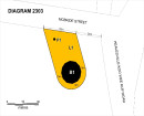
FIVE MILE CREEK BLUESTONE CHANNEL
(off) PASCOE VALE ROAD, ESSENDON, MOONEE VALLEY CITY

Statement of Significance
What is significant?
The section of Five Mile Creek between Pascoe Vale Road and the west of the North Eastern railway line, which is contained in a bluestone-lined channel, is significant. The channel floor is two pitches wide, and the sloping sides are two pitches high. Set back to either side are bluestone retaining walls.
How is it significant?
The Five Mile Creek Bluestone Channel is of local historic significance to the City of Moonee Valley.
Why is it significant?
It is historically significance for its association with the development of Essendon and Strathmore during the interwar period and demonstrates how the natural environment has been modified as the land has been settled and developed. It is representative example of how creeks were transformed into stone-lined channels in an attempt to improve drainage capacity and reduce the effects of flooding due to increased run-off from suburban development. (Criteria A & D)
-
-
-
-
FORMER NORTH PARK
 Victorian Heritage Register H1286
 -
MOONEE PONDS CREEK 1
 Victorian Heritage Inventory
 -
MOONEE PONDS CREEK 2
Victorian Heritage Inventory
-
"1890"
 Yarra City
 -
"AMF Officers" Shed
 Moorabool Shire
 -
"AQUA PROFONDA" SIGN, FITZROY POOL
Victorian Heritage Register H1687
-
-
1) ST. ANDREWS HOTEL AND 2) CANARY ISLAND PALM TREE
 Nillumbik Shire
 -
-
-


 - Shire of Eltham Heritage Study 1992")