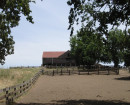
Peter the Great, White Jacket and Blue Jacket Mines and Alluvial Workings
Eaglehawk-Neilborough Road EAGLEHAWK NORTH, GREATER BENDIGO CITY
 Mine, Dam and Alluvial Workings")
 Alluvial Workings")
 Mine and Alluvial Workings")
Statement of Significance
[Peter the Great Gully (right hand branch)]
The site has a representative sample of shallow alluvial and reef workings (criterion C). It contains what is probably the oldest mining dam in the Bendigo region and an early, relatively intact and representative area of shallow alluvial workings which has potential for education and interpretation (criterion A and criterion D).
[Peter the Great Gully (left hand branch)]
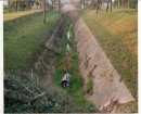
The site has potential for education and interpretation as it contains a sequence of uses or functions over time from well-defined shallow alluvial sinkings and puddling to ground sluicing (criterion C and criterion D).
[Blue Jacket Reef]
The site is representative of small-scale shallow alluvial and reef workings to be found in the Whipstick area (criterion D).
-
-
-
-
-
ONE-EYED GULLY ALLUVIAL WORKINGS - PUDDLER 4
 Victorian Heritage Inventory
 -
WHITE GULLY ALLUVIAL WORKINGS
Victorian Heritage Inventory
-
PETER THE GREAT DAM
Victorian Heritage Inventory
-
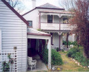
'Altona' Homestead (Formerly 'Laverton' Homestead) and Logan Reserve
 Hobsons Bay City
 -
-
-
-