OLD LEAD DIGGINGS
OLD LEAD ROAD AND OLD LEAD ROAD DUNOLLY, LODDON SHIRE, CENTRAL GOLDFIELDS SHIRE
-
Add to tour
You must log in to do that.
-
Share
-
Shortlist place
You must log in to do that.
- Download report


Statement of Significance
What is significant?
How is it significant?
Why is it significant?
-
-
OLD LEAD DIGGINGS - History
HISTORY
Rush to the Old Lead
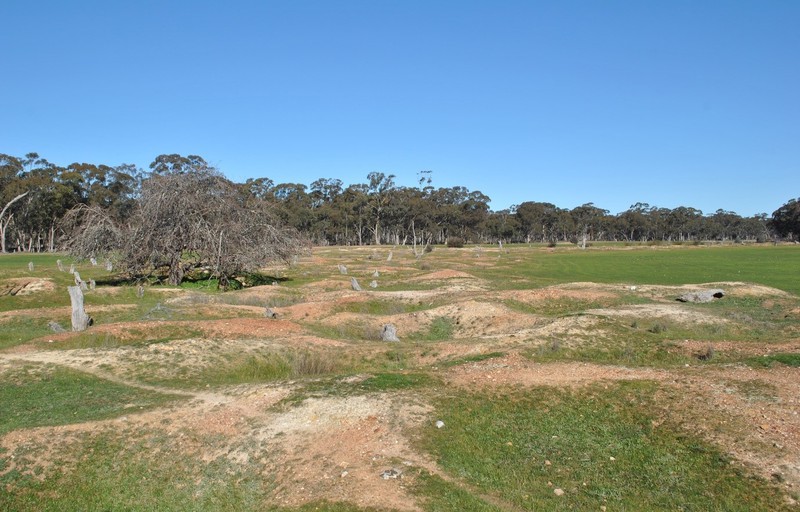
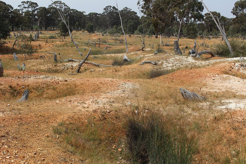
Gold mining began around Dunolly in 1853 but discoveries nearby at Tarnagulla, Moliagul, Inkerman, Rheola and elsewhere sent thousands of miners surging back and forth across the district over the following years. The Old Lead at Dunolly, originally known as German Gully, had been quietly prospected for several years prior to 1856 but returns were patchy. However, the discovery of large nuggets at depth in June and July 1856, ignited a massive rush of diggers back to what became known as the Old Lead and temporarily ‘depopulated half the diggings towns in Victoria’. Thousands of miners quickly traced the lead for several kilometres down towards Burnt Creek, through the town of Dunolly and beyond, where it became a wet lead. At the pinnacle of the rush in September 1856, there were an estimated 30,000–50,000 miners on the Old Lead Diggings and in Dunolly itself. The Dunolly rush was of the same scale as the more famous Forest Creek (Chewton-Castlemaine) gold rush of 1852–53, where the population was estimated at 25,000–30,000 people. The area between the towns of Dunolly, Inglewood and Wedderburn forms the Golden Triangle, which has produced more large nuggets than anywhere else on earth.Mining along the Old Lead involved deep sinking, digging shafts ten-twenty metres deep to hit the auriferous deposit. A ‘lead’ was a deep alluvial auriferous deposit or gutter, often following the course of a creek or gully. Most gold on the Old Lead Diggings was in the form of nuggets, found at depth where gold had accumulated after eroding from a nearby reef. Mullock or spoil from the shaft was hauled up manually by bucket or windlass and dumped around the edges of the shaft. The small size of claims and crowded conditions meant there was limited space available to stack mullock and washdirt. All washing was done in the creek. Luckily for the miners, good rain in the spring of 1856 kept the water holes full.Historian James Flett described the riches of the Old Lead as ‘prodigious’. In the week 4-11 August 1856, for example, eight nuggets were reported ranging from 72 ounces to 336 ounces. On 4 October 1856 miners discovered the Dunolly Nugget, 2952 ounces (91.8 kg) gross weight. Described as ‘a most unlovely-looking long piece of rust-coloured quartz and gold’, when melted down it produced 1363 ounces (42 kg) of gold and was one of the largest gold nuggets ever found in Victoria. There were almost 100 nuggets recorded from the Old Lead greater than twenty ounces (0.6 kg) in weight, although many large specimens were never reported.Small man’s diggings
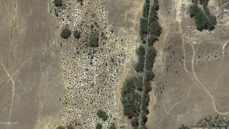
Miners worked at Dunolly in 1856 in the aftermath of the Eureka rebellion, which had taken place only 18 months earlier. One of the many outcomes of the rebellion and the subsequent Commission of Enquiry was to maintain access to goldfields for small miners and restrict larger companies from monopolising claim areas. When the rush to the Dunolly Old Lead occurred in mid-1856, miners worked their claims under the 1855 Act to amend the Laws relating to the Gold Fields (18 Vict. 37) and regulations published in the Victoria Government Gazette on 8 April 1853 and 13 June 1855. Each miner was allowed an area of 3.6 metres square, with up to four miners working as a party allowed to combine their claims into 7 metres square. Special approval (‘a written sanction’) was required to peg out larger areas, although companies could take out leases of up to 160 acres on worked ground that had been abandoned. A single miner was thus entitled to a claim area of just 13 metres square, while parties of four miners could hold 53 metres square. The distribution of shaft holes on the Dunolly Old Lead is consistent with these small claim sizes, where shafts are typically five-ten metres apart.Decline of the rush
The huge influx of diggers to the Dunolly goldfield meant that less than half had been able to get a claim on the Old Lead and the number of miners soon declined. Secretary of Mines Robert Brough Smyth recorded that Daisy Hill, Alma, Jones’s Creek, Bet-Bet, Kingower and other places were so rich that the miners dispersed rapidly. By 1860 the population of the entire Dunolly mining division was reduced to 3,800, including 950 Chinese. In 1862 there was a further rush to the Old Lead, on ground near Hughes’ store, but by 1865 the population of the Old Lead was 260. Despite the huge exodus, however, many miners settled down to live and work along the Old Lead. According to Smyth, they ‘built little places and kept goats, fowls and gardens to help tide them over bad times. They … erected a number of puddling machines and every now and again they came across an astonishing patch of nuggets’.Drought across Victoria in the mid-1860s meant that alluvial mining was extremely difficult. The Dunolly mining surveyor, R.J. McMillan, described ‘the unprecedented scarcity of water. Puddling generally is all but at a standstill. All the dams, with but few exceptions, [are] dry’. The following years saw numerous minor rushes to the Old Lead, with prospecting continuing on a small scale into the early 20th century. A pump hydraulic sluice began operating on the Old Lead around 1907, just north of Dunolly at Delideo Reserve. The lease area was 166 acres and the operation processed almost 250,000 cubic yards of alluvium from seven acres, for a yield of 1,150 ounces of gold from 1908 - 1909.Post-mining landscape change
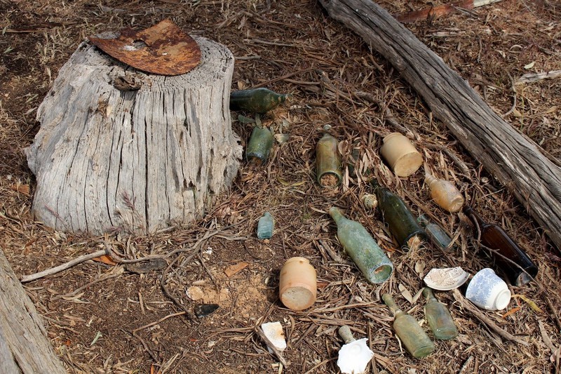
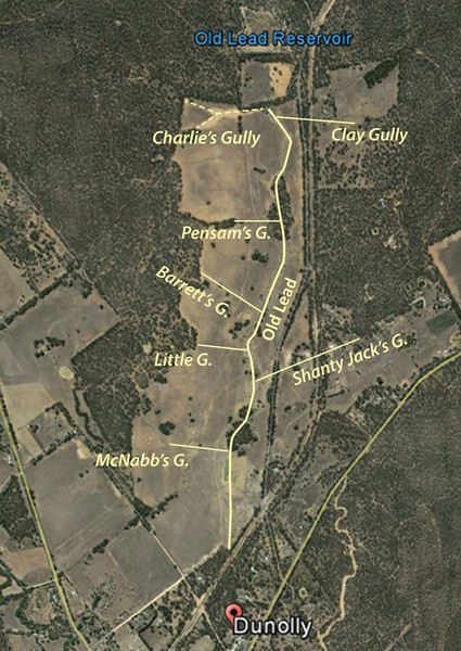
The Old Lead was described by Flett as originally ‘six hundred paces wide’ (c. 400 m) but the physical evidence of deep sinking along the lead is now only about 100 metres wide. This indicates that 100 metres or more of mine shafts and related workings, and possibly diggers’ huts and gardens, along each side of the lead have been filled in and restored to pasture by the previous landowners. The Flett family who owned the land until the early 2010s concentrated on farming but kept the central portion of the diggings and tributary gullies intact. Much of the adjacent grazing/cropping land is very clean, with virtually no surface evidence of domestic or industrial discard. There were at one time tens of thousands of miners working along the diggings, many of whom lived close by in tents or huts, with the residence entitlement of the Miner’s Right having been introduced in early 1855. The domestic discard from miners’ residences at the time must have been extensive but most of this material has since been cleared away and probably pushed into old mine shafts as part of the clean-up process. Both eastern and western edges of the Old Lead Diggings are clearly defined, with a sharp transition between pasture and mining areas.Filling in and levelling out mined areas along the edges of the Old Lead expanded the grazing area after mining ceased. Also, many trees were ring-barked and cut down to maximise grass growth. Many of the stumps show evidence of ring-barking and sawing, and the weathering of the stumps indicate the trees were felled many years ago. Farmers historically believed that trees deprived grass of light, water and nutrients, so they waged war on the trees, ringbarking, chopping, cutting and burning to ‘sweeten the grass’. After mining ceased on the Old Lead, many of the trees originally cut down by the miners grew back. Most of these, however, were subsequently cut down again and burnt off by the landowner to grow as much grass as possible.Miners obliterated the creek that originally ran down the Old Lead from north to south and it remains eradicated to this day. The Old Lead Reservoir, built in 1860 and located immediately north of the Old Lead place boundary, traps the modest flow of the remnant watercourse and diverts it into a now broken pipe that runs beneath the Old Lead Diggings.A large area of remnant mining shafts at the northern end of the Old Lead Diggings, Dunolly, covering an area of more than 200 metes by 100 metres, is likely to have been destroyed using heavy machinery in February 2019 in search of gold. Historically this area was known as Charlie’s Gully.Archaeological remains of historical mining activity extend well beyond the boundaries of the Old Lead Diggings into adjacent properties and nearby areas of the Dunolly-Inglewood State Forest. The Old Lead Diggings at Dunolly are thus part of a wider landscape of historical mining activity known as the Golden Triangle, covering the area between Dunolly, Inglewood and Wedderburn, where gold was often found in the form of large nuggets. The Welcome Stranger, the largest gold nugget in the world, was found in 1869 at Moliagul, twelve km to the north of Dunolly.
KEY REFERENCES
Bannear, D. 1994, Historic Mining Sites in the Dunolly Mining Division, Department of Conservation and Natural Resources, North-West Area, Bendigo, Vic.Birrell, R. 1998, Staking a Claim: Gold and the Development of Victorian Mining Law. Melbourne University Press, Melbourne.Dunn, E.J. 1979 (1912), List of Nuggets Found in Victoria. Reprint, Memoirs of the Geological Survey of Victoria No.12, Melbourne.Flett, J. 1956, Dunolly: Story of an Old Gold-Digging. First edition, Poppet Head Press, Melbourne.Flett, J. 1974, Dunolly: Story of an Old Gold-Digging. Second edition, The Hawthorn Press, Melbourne.Hocking, G. 2007, Castlemaine From Camp to City: A Pictorial History of Forest Creek & the Mount Alexander Goldfields 1835-1900. New Chum Press.Kennedy, B.E. 1976, Vogel, Sir Julius (1835-1899), in Serle, G. and Ward, R. (eds), Australian Dictionary of Biography Vol.6, Melbourne University Press, Melbourne, pp.334-335.Marlow, A.G. and Bushell, D. 1995, Dunolly. 1:100 000 Map Area Geological Report. Geological Survey Report 105, Energy & Minerals Victoria, Melbourne.Sellars, D.B. 1910, Dredge Mining and Hydraulic Sluicing. In Annual Report of the Secretary for Mines for the Year 1909. Mines Department, Melbourne.Smyth, R.B. 1980, The Gold Fields and Mineral Districts of Victoria, Facsimile of 1869 edition, Queensberry Hill Press, Melbourne.Tully, J. 2013, Dunolly Maps: Detailed Maps of the Goldfields. Weila Publishing, Dunolly, Vic.
OLD LEAD DIGGINGS - Assessment Against Criteria
Criterion WHAT IS SIGNIFICANT? The Old Lead Diggings, Dunolly includes a dense aggregation of several thousand remnant mining shafts that resulted from the search for nuggety gold. The place contains other archaeological features including artefact scatters a hotel and house site. HOW IS IT SIGNIFICANT? The Old Lead Diggings, Dunolly is of historical and archaeological significance to the State of Victoria. It satisfies the following criterion for inclusion in the Victorian Heritage Register:
Criterion A Importance to the course, or pattern, of Victoria’s cultural history.
Criterion C Potential to yield information that will contribute to an understanding of Victoria’s cultural history.
Criterion D Importance in demonstrating the principal characteristics of a class of cultural places and objects. WHY IS IT SIGNIFICANT? The Old Lead Diggings, Dunolly is significant at the State level for the following reasons: The Old Lead Diggings, Dunolly is significant as the site of one of the largest and richest nineteenth century gold rushes in the history of Victoria, and possibly Australia. The scale and intactness of the place is highly evocative and reveals the magnitude of the rush and the mining techniques used by the diggers. The pattern of remnant shaft holes, located in close proximity to one another, demonstrates how the place functioned as a ‘small man’s diggings’ in the aftermath of the Eureka uprising. The lead was rushed in 1856, when 30,000-50,000 miners were on the Old Lead Diggings and in Dunolly itself. The goldfield yielded dozens of large nuggets more than twenty ounces (0.6 kg) in weight. The area between Dunolly, Inglewood and Wedderburn forms part of the Golden Triangle, which has produced more large nuggets than anywhere else on earth. [
Criterion A] The Old Lead Diggings, Dunolly is significant as an extensive and well-preserved historical and archaeological landscape characterised by a dense aggregation of thousands of mine shafts that resulted from the search for nuggetty gold. The place also contains the archaeological remains of a store and house site that operated during the gold rush. Scatters of historical archaeological artefacts are visible across the site and are contained within many of the shaft holes. The place has the potential to yield important information about the scale and technological history of gold mining, the cultural history of gold mining, the material culture of the gold fields, and the gold seekers themselves. [
Criterion C] The Old Lead Diggings, Dunolly is significant as a characteristic and well-preserved example of places associated with early deep sinking on the Victorian goldfields. The site includes several thousand closely spaced mining shafts that indicate the scale, intensity and technology of deep sinking from the early years of the gold rush in Victoria. The remains also indicate the small claim nature of early goldfields in Victoria, where limited size claims allowed larger numbers of miners to dig for gold. [
Criterion D]
OLD LEAD DIGGINGS - Permit Exemptions
General Exemptions:General exemptions apply to all places and objects included in the Victorian Heritage Register (VHR). General exemptions have been designed to allow everyday activities, maintenance and changes to your property, which don’t harm its cultural heritage significance, to proceed without the need to obtain approvals under the Heritage Act 2017.Places of worship: In some circumstances, you can alter a place of worship to accommodate religious practices without a permit, but you must notify the Executive Director of Heritage Victoria before you start the works or activities at least 20 business days before the works or activities are to commence.Subdivision/consolidation: Permit exemptions exist for some subdivisions and consolidations. If the subdivision or consolidation is in accordance with a planning permit granted under Part 4 of the Planning and Environment Act 1987 and the application for the planning permit was referred to the Executive Director of Heritage Victoria as a determining referral authority, a permit is not required.Specific exemptions may also apply to your registered place or object. If applicable, these are listed below. Specific exemptions are tailored to the conservation and management needs of an individual registered place or object and set out works and activities that are exempt from the requirements of a permit. Specific exemptions prevail if they conflict with general exemptions. Find out more about heritage permit exemptions here.Specific Exemptions:Categories of works or activities exempt from permit application (PERMIT EXEMPTIONS)It should be noted that Permit Exemptions can be granted at the time of registration (under s.38 of the Heritage Act). Permit Exemptions can also be applied for and granted after registration (under s.92 of the Heritage Act).Under s.38 of the Heritage Act 2017 the Executive Director may include in his recommendation categories of works or activities which may be carried out in relation to the place or object without the need for a permit under Part 5 of the Act. The Executive Director must not make a recommendation for any categories of works or activities if he considers that the works or activities may harm the cultural heritage significance of the place or object. The following permit exemptions are not considered to cause harm to the cultural heritage significance of the Old Lead Diggings, Dunolly:General Conditions· All exempted alterations are to be planned and carried out in a manner which prevents damage to the fabric of the registered place or object.· Should it become apparent during further inspection or the carrying out of works that original or previously hidden or inaccessible details of the place or object are revealed which relate to the significance of the place or object, then the exemption covering such works shall cease and Heritage Victoria shall be notified as soon as possible.· All works should ideally be informed by a Conservation Management Plan prepared for the place. The Executive Director is not bound by any Conservation Management Plan, and permits still must be obtained for works suggested in any Conservation Management Plan.· Nothing in this determination prevents the Heritage Council from amending or rescinding all or any of the permit exemptions.· Nothing in this determination exempts owners or their agents from the responsibility to seek relevant planning or building permits from the relevant responsible authority, where applicable.Specific Permit ExemptionsThe following activities are permit exempt as long as they do not remove or demolish, damage or despoil, develop or alter or excavate, relocate or disturb the mining shafts or any other archaeological features.· The continuation of existing agricultural practices in current locations including management of livestock grazing.· Continuation of current vegetation maintenance practices.· Pruning of dead or dangerous trees to maintain safety.· Weed and vermin control including above ground removal of noxious plants and weeds and the laying of traps and poisons.OLD LEAD DIGGINGS - Permit Exemption Policy
The purpose of the permit guidelines is to assist when considering or making decisions regarding works to a registered place. It is recommended that any proposed works be discussed with an officer of Heritage Victoria prior to making a permit application. Discussing proposed works will assist in answering questions the owner may have and aid any decisions regarding works to the place.The extent of registration of the Old Lead Diggings, Dunolly in the Victorian Heritage Register affects the whole place shown on Diagram 2402 including the land, archaeological features and deposits, trees, landscape elements and other features. Under the Heritage Act 2017 a person must not remove or demolish, damage or despoil, develop or alter or excavate, relocate or disturb the position of any part of a registered place or object without approval. It is acknowledged, however, that alterations and other works may be required to keep places and objects in good repair and adapt them for use into the future.If a person wishes to undertake works or activities in relation to a registered place or registered object, they must apply to the Executive Director, Heritage Victoria for a permit. The purpose of a permit is to enable appropriate change to a place and to effectively manage adverse impacts on the cultural heritage significance of a place as a consequence of change. If an owner is uncertain whether a heritage permit is required, it is recommended that Heritage Victoria be contacted.Permits are required for anything which alters the place, unless a permit exemption is granted. Permit exemptions usually cover routine maintenance and upkeep issues faced by owners as well as minor works. They may include appropriate works that are specified in a conservation management plan. Permit exemptions can be recommended by the Executive Director, Heritage Victoria (under s.38 of the Act) and/or determined by the Heritage Council of Victoria (under s.49(3) of the Act). They can be also be granted after registration (under s.92 of the Act). It should be noted that the addition of new buildings to the registered place, as well as alterations to the interior and exterior of existing buildings requires a permit, unless a specific permit exemption is granted.Disrepair of registered place or registered objectUnder s.152 of the Act, the owner of a registered place or registered object must not allow that place or object to fall into disrepair.Failure to maintain registered place or registered objectUnder s.153 of the Act, the owner of a registered place or registered object must not fail to maintain that place or object to the extent that its conservation is threatened.Conservation management plansIt is recommended that a Conservation Management Plan is developed to manage the place in a manner which respects its cultural heritage significance.Aboriginal cultural heritageA portion of this place is included in the Victorian Aboriginal Heritage Register (VAHR). The Heritage Act 2017 and the Aboriginal Heritage Act 2006 are separate pieces of legislation. It should be noted that satisfying the requirements of one Act may not satisfy the requirements of the other. Under the Heritage Act 2017 permits are required for any works or activities which alter the place or object, unless a permit exemption is granted. This applies to all parts of the registered place including fabric associated with Aboriginal and non-Aboriginal cultural heritage values. Please contact Aboriginal Victoria to understand the requirements under the Aboriginal Heritage Act 2006.Human remainsIf any suspected human remains are found during any works or activities, the works or activities must cease. The remains must be left in place and protected from harm or damage. Victoria Police and the State Coroner’s Office must be notified immediately. If there are reasonable grounds to believe that the remains are Aboriginal, the Coronial Admissions and Enquiries hotline must be contacted immediately on 1300 888 544. As required under s.17(3)(b) of the Aboriginal Heritage Act 2006 all details about the location and nature of the human remains must be provided to the Secretary (as defined in the Aboriginal Heritage Act 2006).Other approvalsPlease be aware that approval from other authorities (such as local government) may be required to undertake works.ArchaeologyAny works at the place require a permit unless a permit exemption applies. Advice should be sought from the Archaeology Team at Heritage Victoria.Cultural heritage significanceOverview of significanceThe cultural heritage significance of the Old Lead Diggings, Dunolly lies in the well-preserved remains of several thousand remnant mining shafts along the main lead and tributary gullies associated with deep sinking for nuggetty gold. The lead was rushed in 1856-1857 by at least 30,000 miners and became one of the richest goldfields in the history of Victoria. The shafts along the Old Lead and associated gullies are closely spaced, indicating the density of workings on small claims. The well-preserved remains have the potential to provide important information about the history, culture and technology of gold mining in nineteenth-century Victoria.
-
-
-
-
-
OLD LEAD DIGGINGS
 Victorian Heritage Register H2402
 -
OLD LEAD DIGGINGS
 Victorian Heritage Inventory
-
'Altona' Homestead (Formerly 'Laverton' Homestead) and Logan Reserve
 Hobsons Bay City
-
-


