Cecil Street Heritage Precinct
Cecil Street WILLIAMSTOWN, Hobsons Bay City
-
Add to tour
You must log in to do that.
-
Share
-
Shortlist place
You must log in to do that.
- Download report
Statement of Significance
Statement of Significance What is Significant?
The Cecil Street Heritage Precinct, which comprises all land in HO1 and generally includes properties with a frontage or side boundary to Cecil Street, Williamstown.
How is it Significant?
The Cecil Street Heritage Precinct is of local historic, social and aesthetic significance to the City of Hobsons Bay.
Why is it Significant?Historically, Cecil Street formed the southern boundary of Williamstown as originally surveyed by Hoddle in 1837 and is significant for its ability to illustrate important phases in its development from soon after the first land sales between 1837 and 1840 to its proclamation as a city in 1909. It assists in understanding and interpreting how streets in proximity to the port area traditionally included a mix of residential and commercial uses and is notable for its high proportion of very early residential and commercial development including a number of pre-1860 dwellings. (AHC criteria A4, D2 and G1)
Aesthetically, Cecil Street is significant as an integral part of the broader Government Survey heritage precinct and includes characteristics that are typical of the broader precinct as well as those that are unique. Despite some intrusive and unrelated postwar development, the precinct retains intact groups of predominantly nineteenth and early twentieth century dwellings, with interspersed public, church and commercial buildings that are characteristic of this part of the broader Government Survey heritage precinct and an essential part of the historic character of early Williamstown.
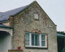
Key elements, which are typical of the Government Survey heritage precinct include:- Unusual or rare building styles and types such as the basalt houses and the timber duplex houses with no dividing wall that are characteristic of this part of Williamstown but less common elsewhere in the metropolitan area.
- The unifying effect throughout the precinct of groups of predominantly Victorian and Edwardian era houses with common or similar characteristics of design, siting and scale that create cohesive and homogeneous streetscapes. Many are externally intact and others, although altered, still retain their distinctive form and siting and hence contribute to the precinct.
- The sections of the roadway in its basic early layout and the remnant mature exotic street planting that combines with exotic planting in private gardens to reinforce and enhance the period expression of the precinct.
The distinctive elements of Cecil Street are:
- The contrast of the modest residential buildings with:
- The grand civic and public buildings on key sites throughout the precinct.
- The traditionally styled (two-storey, stuccoed and parapeted) early hotels located on corner or mid block sites and constructed to the building line.
- The narrow street width, which creates a greater sense of enclosure than in the other main Government Survey streets.
On this basis, the following properties and other elements contribute to the significance of the precinct:
- Cecil Street (even) 12-14, 20, 22, 26-30, 34, 46-50, 56-58, 82, 86, 116, 120, 132-140, 146, 150-154, 156-160, 174, 180 and 182
- Cecil Street (odd) 13, 23-47, 53, 55, 61-69, 85-89, 97, 103, 105-123, 127, 129, 133-45, 155, 173 and 185.
- Surviving sections of nineteenth century street layout and mature street trees.
Please note that some heritage places within this precinct may be listed as contributory to the Government Survey Heritage Precinct or have an individual citation in this Study.
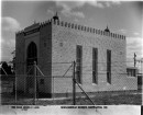
-
-
Cecil Street Heritage Precinct - Historical Australian Themes
Principal Australian Historical Theme(s)
Making Suburbs
Cecil Street Heritage Precinct - Physical Description 1
Cecil Street is part of the Government Survey heritage precinct and generally comprises all the properties with a frontage or side boundary to Cecil Street for between Ferguson and Kanowna Streets.
The Government Survey heritage precinct was laid out in a series of intersecting grids between 1837 and 1855 and Cecil Street was one of the three original streets surveyed by Hoddle in 1837 that were orientated to generally follow the line of the coast to the north: Between Ferguson and Parker Streets it runs almost north-south, before changing direction to run almost east-west between Cole and Kanowna Streets.
Cecil Street is 20 metres wide which is 10 metres narrower than the other major streets south of Ferguson Street such as Electra, Pasco and Parker Streets. The relative narrowness provides a greater sense of enclosure, which is enhanced by mature street trees in certain sections.
Primarily, it is a residential street with interspersed commercial and public buildings, such as Stags Head Hotel and the former George Hotel, and St. Andrews Presbyterian Church. St. Mary's Roman Catholic Church complex, and Williamstown State School form part of a distinctive sub-precinct of public buildings at the point where the street changes direction between Parker and Cole Streets.
The northern end of Cecil Street is closed off by a view to the Rose of Australia Hotel in Ferguson Street with the spire of the Stevedore Street Uniting Church rising above it. The intersections with Pasco, Parker and Cole Streets afford glimpses to the boat yards and Commonwealth Reserve on Nelson Place and to Hobson's Bay beyond. There are views within the Street to key landmarks such as St Andrew's, and St Mary's Catholic Church complex.
The integrity of Cecil Street has been diminished by inappropriate and unrelated postwar development that disrupts the historic expression of the street as whole. However, there are still remarkably intact sections that possess a distinctive nineteenth century streetscape character, which derives from:
- Visually prominent commercial, civic and public buildings, which include:
- The traditionally sited (corner, and built to building line) and styled hotels such as the Stag's Head, the former George, and the former Crown.
- The civic and public buildings including St Mary's Church and Manse, St Andrew's Church, and Williamstown Primary School 1878 building, all constructed of basalt in Gothic Revival style.
- The cohesive and homogeneous streetscapes created by the mid to late nineteenth and early twentieth century residential buildings, which share the following common characteristics:
- simple single or double fronted forms of single storey scale. A notable exception is the two-storey terrace house with an original fence at No. 160, which is a rare example of this type in Williamstown.
- predominantly detached siting parallel to the frontage with similar front and side setbacks
- horizontal weatherboard wall cladding.
- pitched roof forms.
- verandahed forms.
- punched fenestration occupying less than 50% of the wall surface
The predominant building style is Victorian, but there are notable individual Edwardian and interwar examples that are related in terms of their materials, scale, roof forms and siting. The house at 120 Cecil Street is a fine example of an asymmetrical Queen Anne villa with ornate detailing to the verandah, gable ends and windows. Few front fences are original, but most are low and and many are in a related reproduction period style such as timber pickets.
- The early roadway layout in the section between Parker and Pasco Streets that comprises:
- the remnant mature exotic street planting comprising Elm or Plane trees originally on both sides of the road in the gravelled road verge.
- a strip of stone bordered, originally macadamised and now asphalt roadway in the centre of the road reserve
- basalt kerb and channel.
- asphalt paved footpaths.
Since the 1993 City of Williamstown Conservation Study was completed the four storey walk-up flats originally built by the Housing Commission near the corner of Cecil and Cole Streets have been redeveloped, and although more sympathetic in scale, theyare still an intrusive element. Other non-contributory elements include postwar houses that are often unrelated in terms of their scale, materials and siting. The residential character and physical cohesion at the eastern end generally between Windsor Terrace and Kanowna Street is also eroded by industrial uses on the northern side and a vacant corner allotment on the southern side.
Cecil Street Heritage Precinct - Physical Description 2
Associations
Robert Hoddle. Refer also to individual citations
Cecil Street Heritage Precinct - Usage/Former Usage
Context
Cecil Street is an integral part of the Government Survey precinct.
Cecil Street Heritage Precinct - Integrity
Integrity
Since this precinct was originally identified in the City of Williamstown Conservation Study (1993), a number of contributory places have either been demolished, or significantly altered. Consequently, the integrity of the street has been diminished to the extent that only selected groups of contributory places as well as places of individual significance are considered to meet the threshold for inclusion in the planning scheme. The groups are generally in the following locations:
- Between Pasco Street and Cole Street.
- Between Thompson Street and Kanowna Street.
- At the northern end near Ferguson Street.
Heritage Study and Grading
Hobsons Bay - Hobsons Bay Heritage Study
Author: Hobsons Bay City Council
Year: 2006
Grading:
-
-
-
-
-
FORMER MORGUEVictorian Heritage Register H1512
-
WILLIAMSTOWN PRIMARY SCHOOLVictorian Heritage Register H1639
-
RESIDENCEVictorian Heritage Register H0487
-
1 Fordham CourtYarra City
-
10 Fordham CourtYarra City
-
-