Point Gellibrand Heritage Precinct
approximately 24 hectares of foreshore land bounded by Kanowna Street, Hamner Street, Ann Street, Morris Street and the Cyril Curtain Reserve in the south and coastline to the eas WILLIAMSTOWN, HOBSONS BAY CITY
-
Add to tour
You must log in to do that.
-
Share
-
Shortlist place
You must log in to do that.
- Download report


Statement of Significance
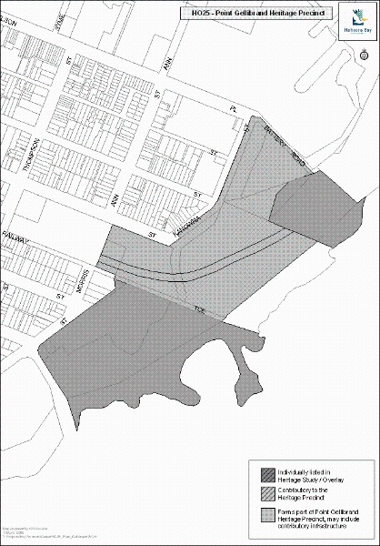
The Point Gellibrand Heritage Precinct, comprising approximately24 hectares of foreshore land bounded by Kanowna Street, Hamner Street, Ann Street, Morris Street and the Cyril Curtain Reserve in the south, and the coastline to the east.
How is it Significant?The Point Gellibrand Heritage Precinct is of local historic, social and scientific (archaeological) significance to the City of Hobsons Bay.
Why is it Significant?Historically and socially, Point Gellibrand is significant for its important roles as a centre of maritime, land transportation and communications activities that were essential to the earliest non-indigenous settlement and development of both Williamstown and Victoria for the following reasons:
- Point Gellibrand was the site of the first permanent European settlement in the Port Phillip district. It was strategically important in terms of the defence of the infant Colony of Victoria and was the first landfall and primary disembarkation point in the colony up until the 1850s.
- The strategic importance of Point Gellibrand is demonstrated by Fort Gellibrand, which was one of the first steps towards the setting up of a defence system for the infant settlement of Port Phillip.
- The Timeball Tower demonstrates the important role of Point Gellibrand in protecting shipping, in providing standard time signals and transmission messages and for its role in the charting of the Bay.
- The important role of the dockyard in both State and Australian history as first the State and then the Commonwealth Shipbuilding Yard. The Alfred Graving Dock was the major single government work of its time in Victoria and one, which captured the public's imagination.
- The important role of Gellibrand, Breakwater and Nelson (Railway) Pier in the export of wheat and wool and the foundations of the unfinished wheat silos, which represent the collapse of this vitally important trade as far as Williamstown is concerned.
- The land corridor which once contained the original lines between the Williamstown Railway Station Precinct and the Gellibrand Pier and Time Ball Tower is historically significant as a tangible visual and physical reminder of the important historical link between the Williamstown line and the railway workshop, railway yard and port activities carried out at Point Gellibrand. The railway workshops were the first in Victoria and served the whole of the State until they were removed to Newport in 1889.
Historically and socially, Battery Road is significant for its strong associations with the Williamstown community for its use, both formal and informal, since the late nineteenth century as a public promenade for leisure and ceremonial purposes. (AHC criterion G1)
Scientifically, Point Gellibrand is also significant for its archaeological deposits, which have significant educative and illustrative potential for demonstrating an important formative period in Victoria's settlement. (AHC criteria A4 and D2)
Please note that some heritage places within this precinct may also have an individual citation in this Study.
-
-
Point Gellibrand Heritage Precinct - Physical Description 1
Point Gellibrand is approximately24 hectares in area and is set on the eastern most end of Hobsons Bay along the coastline of Port Phillip. It is bounded by Kanowna Street, Hanmer Street, Ann Street, Morris Street, and the Cyril Curtain Reserve in the south, and the coastline on the east side.
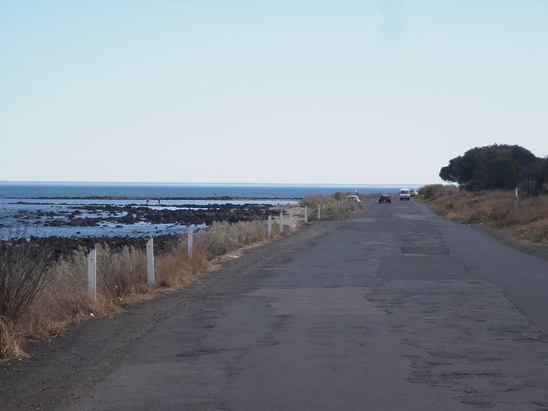
Point Gellibrand generally consists of open parkland with low-level vegetation in most areas. The coastline inter-tidal zone contains areas of basalt outcrops and low level vegetation. The area is also interesting geologically: the volcanic coastline includes the lava blister eroded by the sea, pictured in E.S. Hill's classic The Physiography of Victoria.[1] Its human history has been unusually rich.
The northern section now consists of naval dockyards, and Gellibrand and Breakwater Piers, which project into Hobsons Bay. There is a tank yard occupying the centre of the Piers and a car park south of the naval dockyards. The Time Ball Tower is located at the shore end of Breakwater Pier, with a car park adjacent.
The precinct is traversed by two key roads:
- Battery Road, which begins at the end of Nelson Place and then follows the coastline past Railway Terrace past the former Fort before turning north between the Fort and the Recreation Reserve to join Morris Street at Twyford Street. The former alignment of Battery Road to the seaward side of the Recreation Reserve that once continued to the intersection of Thompson and Morris Streets is closed to traffic, but still exists as an unmade track.
Battery Road has a degraded bitumen surface, and appears to have been progressively widened in places. On the seaward side it is partly protected by a bluestone seawall (see below). The south west section of Battery Road extending from Railway Terrace extension passing along the coastline past the Fort and on the seaward side of the Football Ground (where it is now a track) was shown on maps since the early 1890s and was referred to in newspaper articles since 1880s. It appears to follow the basic alignment of the original convict-built tramway. The section between Railway Terrace and the extension of Nelson Place, and the section which turns north to pass between the Fort and the cricket ground to meet up with Twyford Street appear to date from a later period, most likely some time in the first half of the twentieth century.
- Railway Terrace runs in an east-west direction, centrally through the site and connects to Battery Road at the coastal end.
As described in the History many of the early buildings, places and structures have been removed or greatly modified in the years since the area was first settled. The extant historic fabric on the site includes the following:
Piers and Patent Slip
The Gellibrand Pier, including remnant railway tracks, and Breakwater Pier, including the dressed basalt retaining wall are situated at the north of the site. Nearby is the former Patent Slip.
RailwaysThe Williamstown Railway Station complex is located between Hanmer Street and Railway Terrace and is outside of the Point Gellibrand precinct proper. It comprises the station buildings and platforms, the Ann Street footbridge and the Thompson Street bridge.
Within the precinct, most of the physical evidence including all of the tracks, workshop buildings and other infrastructure associated with the Workshops and the Pier Station within the northern part of the Point Gellibrand precinct has been removed, however, some remnant railway related fabric indicative of previous railway activity including part buried sleepers, lengths of track, bricks and building stone are scattered throughout.
Fort GellibrandFort Gellibrand is situated between Railway Terrace, Battery Road and the Recreation Reserve. The fort area is raised and consists of earthworks, gun emplacements, front magazine, numerous buildings including the Drill Hall and attached residential wing. The batteries have retained their original commanding view over low level open space to the former target area in the Bay. It is the only remaining physical evidence of the system of four battery positions at Point Gellibrand.
Quarries
Remnants of the early quarries can be seen in front of Fort Gellibrand. There were other throughout the precinct, which have been filled.
The Sea WallThe sea wall follows the coastline from Breakwater Pier to the Recreation Ground. As detailed in the history, construction of the seawall adjacent to the railway reserve is believed to have commenced in the 1850s, was not completed till the 1870s, with reconstruction undertaken in the 1960s and later. There is evidence of reconstruction, with the use of concrete capping, both dressed and rock-faced bluestone, and a number of blocks appears to be recycled from buildings. There is also some evidence of earlier wall structures in the water adjacent to the existing lighthouse battery wall. Closer to the fort, the wall has been buried by landfill in places. In the Shelley Beach area, larger stone blocks are evident, concrete capping is used again, and there is clear evidence of the wall being totally re-built or reconstructed. There is a build up of sand and vegetation against the seawall, which mostly obscures it at the Shelley Beach end of the site.
Point Gellibrand Lighthouse (The Timeball Tower)
The Point Gellibrand Lighthouse was constructed in 1849 and replaced an earlier timber structure. It later became known as the Timeball Tower because it was used, from 1858 to 1926, to allow correction of ships' chronometers by the dropping of a large copper ball each afternoon at one o'clock. Wilson Evans has a detailed account of the provision of standard time signals and associated activities at Williamstown in Port of Many Prows on pp.108-09.
The Recreation Reserve
The Recreation Reserve at the southern end of the precinct includes the Cricket Oval with the large reinforced concrete grandstand that was constructed in 1930.
[1] Figure 251, p.190 (1946 ed.)
Point Gellibrand Heritage Precinct - Integrity
Integrity
Moderate to Low.
Point Gellibrand Heritage Precinct - Usage/Former Usage
Context
The Point Gellibrand precinct is an integral part of the foreshore area with strong links to the maritime and defence history of Williamstown.
Point Gellibrand Heritage Precinct - Historical Australian Themes
Principal Australian Historical Theme(s)
Governing, Developing Local, Regional and National Economies, Developing Cultural Institutions and Ways of Life
Point Gellibrand Heritage Precinct - Physical Description 2
Associations
Victorian Colonial Government, Commonwealth Government
Heritage Study and Grading
Hobsons Bay - Hobsons Bay Heritage Study
Author: Hobsons Bay City Council
Year: 2006
Grading: Local
-
-
-
-
-
FORMER MORGUE
 Victorian Heritage Register H1512
 -
WILLIAMSTOWN PRIMARY SCHOOL
 Victorian Heritage Register H1639
 -
TIME BALL TOWER
 Victorian Heritage Register H1649
-
3 Sherwood Street
 Yarra City
 -
Archaeological site
 Southern Grampians Shire
 -
BLACKWOOD HOMESTEAD COMPLEX AND CEMETERY
 Southern Grampians Shire
-
-


