Back to search results
MOUNT ROUSE AND CRATER RESERVE
Mount Rouse Tourist Road PENSHURST, Southern Grampians Shire
MOUNT ROUSE AND CRATER RESERVE
Mount Rouse Tourist Road PENSHURST, Southern Grampians Shire
All information on this page is maintained by Southern Grampians Shire.
Click below for their website and contact details.
Southern Grampians Shire

23358 Mount Rouse and Crater Reserve Penshurst 1553


On this page:
Statement of Significance
What is Significant?
The Mount Rouse Crater reserve is located at the Termination of the Mount Rouse Tourist Road, approximately five kilometers south of the township of Penshurst. The reserve consists of 63hectares around the summit of Mount Rouse, an extinct volcano that has a large crater in the centre. The lower slopes of the reserve have had the indigenous vegetation denuded, and there are substantial plantings of Monterey Pines (Pinus radiata) on the higher slopes, particularly on the northwestern and northeastern sides. There are some built structures within the reserve, a fire tower located on the summit, steps up to a lookout and a carpark. Major Mitchell named Mount Rouse in 1836, presumably after the early Sydney settler, Richard Rouse who established Rouse Hill. The Mountain was the centre of the 100 square mile 'Reserve', which was the Mount Rouse Aboriginal Protectorate from the 1840s. The Protectorate failed and from about 1852 the township of Penshurst began to develop centred on the Protectorate's remaining buildings, now the Police Reserve. The current reserve dates from the 1850s, when land immediately around the crater was reserved as a "Public Park" and a water reserve. The Mount Rouse Reserve was formally gazetted in 1870. Plantings of exotic species, such as buffalo grass, Monterey Pines and the removal of indigenous vegetation have led to serious erosion on the Mountain. A revegetation program started in the 1960s has halted this, planting a number of species of native trees and shrubs. Quarrying has been undertaken on the northeast face of Mount Rouse since the nineteenth century. The reserve is in good condition and retains a high degree of integrity.
How is it significant?
The Mount Rouse and Crater Reserve is of historical, social and aesthetic significance as a Significant Landscape to Southern Grampians shire and to the township of Penshurst.
Why is it significant?
The Mount Rouse and Crater Reserve is of historical significance for its associations with the very early squatting run of John Cox and with the Aboriginal Protectorate. It is of continuing historical significance for its development as a cultural landmark through various planting programs. It is of social significance for its role as a recreation reserve. It is of aesthetic significance for its association with the homestead, Kolor and its landscaping, located on its western slope.
Show more
Show less
-
-
-
-
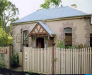
KOLOR HOMESTEAD
 Victorian Heritage Register H0541
 -
MOUNT ROUSE AND CRATER RESERVE
 Southern Grampians Shire
-
'Altona' Homestead (Formerly 'Laverton' Homestead) and Logan Reserve
 Hobsons Bay City
 -
-
-
-