GREENWICH PIER
THE STRAND NEWPORT, HOBSONS BAY CITY
-
Add to tour
You must log in to do that.
-
Share
-
Shortlist place
You must log in to do that.
- Download report


Statement of Significance
This record has minimal details. Please look to the right-hand-side bar for any further details about this record.
-
-
GREENWICH PIER - History
Jill Barnard Report History -
Greenwich Pier was built by the Geelong and Melbourne Railway Company as a temporary pier in 1857. The company had been formed in 1852 to build and operate a railway line between Melbourne and Geelong. It was proposed that the Geelong line would connect to another proposed private railway line to be built by the Melbourne, Mount Alexander and Murray River Railway Company between Melbourne and Williamstown. The junction of the two lines was to be at Greenwich, later known as Newport (Butler, Vol 2, 2000, p. 25). The MMA and MR R. Coy ran out of funds in 1856 and the Victorian Government took over the company's works, forming the Victorian Railways. The line between Melbourne and Williamstown would become the first line built by the Victorian Railways. It was not completed, however, until January 1859. The Geelong and Melbourne Railway Company's line from Geelong reached Greenwich and opened for passenger traffic on 25 June, 1857. Because the line between Melbourne and Williamstown had not been completed, the Geelong and Melbourne Railway Company was forced to construct a temporary line, station and pier at Greenwich (Geelong and Melbourne Railway Company Directors' Report to Shareholders, 1 February 1859, PROV, VPRS 1095, p/0, unit 8 Bundle 7 Number 18). The temporary pier and line cost the company £6,000. The pier was constructed to enable passengers from Melbourne to Geelong to catch a steamer to Greenwich to meet the train. On the day that the railway line opened, passengers bound for the celebrations in Geelong landed at Greenwich in the steamer, Citizen, waited for some time for the train to arrive, then picked their way through the mud to board the train (Argus, 27 June 1857, p.4). The pier is noted on an 1858 map of Hobsons Bay (Ross, Coastal Survey 85, Historic Plan Collection, PROV).
The temporary line and pier at Greenwich were not used for very long. George Ward Cole, owner of the land through which the temporary line ran, issued an injunction against the Geelong and Melbourne Railway Company for running their trains through his land. Consequently, by late September 1857, the company had received permission from the Victorian Government to use the completed section of the Melbourne and Williamstown line between Greenwich and Williamstown. A temporary station building was constructed at the Railway Pier, Williamstown and arrangements were made for the steamer Citizen to meet the trains here (Argus, 18 September, 1857, p. 4).
An 1879 map of the Port of Melbourne indicates a pier in line with North Road, Newport. This location is now Greenwich Reserve. The Melbourne Harbor Trust began reclaiming land in Greenwich Bay in 1878. This reclamation continued during the twentieth century (Melbourne Harbor Trust reclamation sites circa 1941).
In 1886 the Melbourne Harbor Trust Commissioners, having had their attention brought to the lack of pier accommodation at the north end of Williamstown, proposed re-forming and extending the 'old Greenwich Pier' but planned to wait until
the diversion of the Yarra River (as part of the construction of the Coode Canal) had been completed (Melbourne Harbor Trust Commissioners Annual Report, 1886). There is no evidence that the commissioners ever completed this work, though an 1892 plan of the Port of Melbourne shows a Newport Pier roughly on the site of the Greenwich Pier. This may have been a proposed improvement. The proposed pier is also shown under reclaimed land on a 1924 plan for port improvements.
An article published in the Argus 22 January 1944 reflected that all that remained of the temporary Greenwich pier and railway line were a 'few barnacled piles at the extremity' of the sandy spit that runs along the east side of what is now Greenwich Reserve and Greenwich Bay.
SEE ATTACHMENTS FOR HISTORIC IMAGES
Brad's Report History - Cox's 1864 plan shows a pier used for ballast boat loading that connected to quarry via a tramway that had been used since 1844. The Greenwich Pier was specially constructed in 1853 to connect to the proposed spur of the Geelong and Melbourne Railway line. However, due to an industrial dispute in 1857, the short lived rail service eventually terminated at Newport station, and passengers were forced to walk to the station. This led to the removal of the rail spur and the railway service was extended to connect with a temporary station at Williamstown. It appears that the failure of the pier as a passenger terminal led to its reuse for the ballasting trade. An 1879 plan shows Greenwich pier located to the adjacent south of the Williamstown Steam Ferry, which has an "L" shaped construction. This structure was still extant in 1894 plans, and is labelled as the Ballast Wharf, which, in conjunction with an old training wall, forms the northern part of a small harbour enclosure or dock. The area was subject to extensive land reclamation work at this time, and half this harbour has been backfilled behind the training wall.
GREENWICH PIER - Interpretation of Site
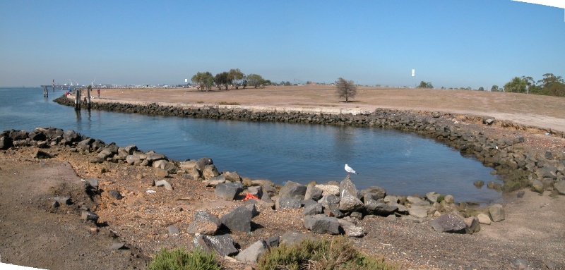
The site has undergone change since the Greenwich Pier was constructed in 1857. There has been land reclamation and the course of the Yarra River has been altered and widened. A cooling channel for the adjacent Newport Power Station has been constructed and there has been extensive landscaping. The exact location of any remains of the Greenwich Pier is uncertain.
GREENWICH PIER - Archaeological Significance
There is potential that remains of a temporary pier, built in the 1850s to service passengers on the Geelong and Melbourne Railway line and known as Greenwich Pier are located beneath reclaimed land at the reserve.
Heritage Inventory Description
GREENWICH PIER - Heritage Inventory Description
Three large timber piles (approx 50 cm diameter) remain above the high water mark at the northern extremity of the site, where the current embankment is eroding.
Sheet piling, wharf, piles & archaeology discard associated with pier use.
Archeological Potential:
Good - inspected 24/3/03
-
-
-
-
-
PRINCE ALBERT HOTEL
 Victorian Heritage Register H1793
 -
OLD YARRA RIVER COURSE STONE EMBANKMENTS
 Victorian Heritage Inventory
 -
YARRA RIVER ENTRANCE TRAINING WALL
 Victorian Heritage Inventory
-
-


