Government Survey Heritage Precinct
Aitken Street and Ann Street and Cecil Street and Charles Street and Cole Street and Council Lane and Cropper Place and Electra Street and Esplanade and Giffard Street and Hamner Street and Illawarra Street and Jackson Street and Kanowna Street and Lyons


Statement of Significance
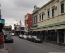
The Government Survey Heritage Precinct, which comprises all land included within HO8 and is generally bounded by Ferguson Street, Nelson Place, Kanowna Street, Morris Street, Esplanade, Giffard Street and Railway Place, Williamstown.
How is it Significant?
The Government Survey Heritage Precinct is of local historic, social and aesthetic significance to the City of Hobsons Bay.
Why is it Significant?Historically, the Government Survey precinct demonstrates the most important and prosperous phase in the development of Williamstown from the mid nineteenth to early twentieth centuries, which was directly associated with the development of the port and later influenced by the development of railways and associated industries. The early settlement of Williamstown and its importance as a port and defence facility also contributes to a broader understanding of the history of Victoria.
Socially, the Government Survey is important for its ability to assist in understanding and interpreting the life style of this isolated and close-knit community during the nineteenth century.
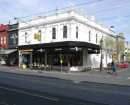
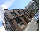
Aesthetically, while there are examples of unrelated postwar development within the precinct, as a whole it retains remarkably intact and cohesive groups of nineteenth and early twentieth century buildings that are an integral part of the special character of early Williamstown. Key elements include:
- The distinctive street layout based on a series of intersecting grids, which illustrates prevailing attitudes towards town planning in the nineteenth century.
- Unusual or rare early building styles and types such as the basalt houses and the timber duplex houses with no dividing wall that are characteristic of this part of Williamstown but less common elsewhere in the metropolitan area.
- The major nineteenth century community and civic buildings, many designed by noted Melbourne architects, both individually and in key groups - notably in Electra Street and the former Market Reserve.
- The unifying effect throughout the precinct of groups of predominantly Victorian and Edwardian era houses with common or similar characteristics of design, siting and scale that creates cohesive and homogeneous streetscapes. Many are externally intact and others, although altered, still retain their distinctive form and siting and hence contribute to the precinct.
- The basic nineteenth century or early street construction and the remnant mature exotic street planting found in some streets that combines with exotic planting in private gardens to reinforce and enhance the period expression of the precinct.
Not all of these elements are found in all streets within the precinct. As a consequence, there are a number of distinctive sub-precincts, which include Cecil Street, Electra Street, Esplanade, Hanmer Street, Nelson Place, Osborne Street, Pasco Street and Verdon Street that have individual citations in this Study. There is also an individual citation for Ferguson Street, which forms the northern boundary of the precinct.
On this basis, the following properties and other elements contribute to the significance of the precinct (Note: All streets numbers are inclusive):
§ Aitken Street (odd) 23-25, 43, 69, 81-83, 87, 153-159 and 163-171 (even) 64, 66, 118-120, 122 and 160.
§ Ann Street (odd) 17, 31, 33 and 43-49 (even) 22-40 and 46.
§ Cecil Street (odd) 13, 23-47, 53, 55, 61-69, 85-89, 97, 103, 105-123, 127, 129, 133-145, 155, 173, 185 (even) 12-14, 20, 22, 26-30, 34, 46-50, 56, 58, 82, 86, 116, 120, 132-140, 146, 150-154, 156-160, 174 and 180-182 (Note: Cecil Street is within the Cecil Street Heritage Precinct (HO1).
§ Charles Street (odd) 3, 5, 9, 11 and 15-19 (even) 6-20.
§ Cole Street (odd) 1, 3, 11-13, 51, 73-77, 83 and 107-113 (even) 52, 56-66, 80-92, 96 and 100 and Cole Street railway bridge (Note: Nos 1 and 3 Cole Street are located within the Nelson Place Heritage Precinct (HO21)).
§ Electra Street (odd) 3, 5, 9-17, 21-25, 41, 51, 55-57 and 65 (even) 2, 6, 8-12, 16, 22, 26-36, 44-48 and 52-70 (Note: Electra Street is located within the Electra Street Heritage Precinct (HO4).
§ Esplanade 4, 5, 5A, 7, 9-14 and 16-20, 23 (Note: Properties west of Giffard Street are located within the Williamstown Beach Heritage Precinct (HO34) and the Hannan's Farm Heritage Precinct (HO13)).
§ Ferguson Street (odd only) 21, 43-45, 49, 51, 55-59, 75, 77, 91-95, 107, 145 and 147-171 and 185 (Refer to Ferguson Street Civic & Commercial Heritage Precinct (HO7)) (Note: No 147 is located in the Verdon Street Heritage Precinct (HO32).
§ Giffard Street (odd) 13-23, 31, 41-43, 49, 59, 61 and 67 (even) 20 and 24-38.
§ Hanmer Street (odd) 67, 77, 81-93, 97 and 119-129 (even) 6-14, 18, 20, 22, 26, 38, 40, 42, 46 64-68, 84, 86 and 90 and the adjacent Williamstown Railway Station complex (Note: Hamner Street is located within the Hanmer Street Heritage Precinct (HO12)).
§ Illawarra Street (odd) 31-41 (even) 12, 16, 18, 20-22, 24, 26, 28, 32-42, 44, 46 and 50
§ Kanowna Street 14 and 38-52.
§ Lyons Street (odd) 27 (even) 2, 6-10, 14, 16, 24-28, 34, 36.
§ Melbourne Road (odd) 5-9, 15-27, 33, 37, 53-61, 69, 75, 77, 83, 89 and 91 and (even) 12.
§ Morris Street 54, 56-58 and 64-68.
§ Nelson Place (odd) 1, 55-57, 85, 123-219, 223-231, 255-57 and 263 (even) 128 and 132 (Note: Nos (odd) 125-219 (even) 128 are located within the Nelson Place Heritage Precinct (HO21)).
§ Osborne Street (odd) 5-11, 17-23, 33-43, 49, 53-57, 63, 67-75, 83-85, 93 and 95 (even) 2, 6-14, 18, 24, 26, 32-44, 48-56, 64, 78 (Note: Properties west of Giffard Street are within the Williamstown Beach Heritage Precinct (HO34)).
§ Parker Street (odd) 1, 71-73, 77 and 81-87 (even) 8-12, 28-32, 50, 52, 60-67, 71-76 and 80-84 (Note: No 1 Parker Street in located within the Nelson Place Heritage Precinct (HO21)).
§ Pasco Street (odd) 15-19, 21, 25-31, 47, 57-61, 69 and 83-93 (even) 4-16, 22-32, 50-56, 62, 64 and 70-76 (Note: Pasco Street is located within the Pasco Street Heritage Precinct (HO24).
§ Perry Street (odd) 3-9 (even) 4-8, 20 and 24-32.
§ Railway Crescent (odd and even) 17-32 (Note: Railway Crescent west of Giffard Street is within the Williamstown Beach Heritage Precinct (HO34).
§ Railway Place (odd and even) 13, 16, 18, 19, 21, 26-29, 32-40, 43-46, 48, 49, 51, 52, 59, 60, 73, 76, 77, 83, 85, 87, 90-91, 93, 94, 97, 100, 107, 112, 113 and 119.
§ Railway Terrace (odd and even) 1, 2, 4, 7, 8, 11-15 and 16.
§ Smith Street 2 and 4.
§ Thompson Street (odd) 13, 15, 17, 19-27, 39-41, 47, 57, 61, 65, 67, 73-75, 77, 87, 89, 93, 97, 103, 113-115 and 123 (even) 4, 8, 10, 14 (trees only), 66-68, 72-76, 80-88, 92-94, 96, 102, 106 and 112-118.
§ Twyford Street (odd) 25, 27, 29, 31, 33-35, 37-39, 41, 63-67 and 73-81 (even) 2, 6, 10, 14, 16, 18, 28, 32, 34, 36, 40, 46-48, 50, 54, 56, 60-70 and 74.
§ Verdon Street (odd) 1, 3, 7-21, 29, 47A, 55-59, 69-77, 79 (Street tree only), 87, 91,93 and 95 (even) 2, 6-16, 40, 48, 50, 66, 70-78, 84, 88-92, 96 and 106-108 (Note: Verdon Street is located within the Verdon Street Heritage Precinct (HO32).
§ Early street and laneway construction and layout and mature street trees throughout the precinct.
Please note that some heritage places within this precinct may also have an individual citation in this Study.
1 Cole Street and 27-29 Pasco Street are not the original buildings - reconstruction has occurred in accordance with the ICOMOS Burra Charter.
-
-
-
-
WILLIAMSTOWN PRIMARY SCHOOL
 Victorian Heritage Register H1639
 -
RESIDENCE
Victorian Heritage Register H0487
-
ST HELLIERS
Victorian Heritage Register H0560
-
DIGHTS MILL SITE
Victorian Heritage Register H1522
-
DUNROE
 Southern Grampians Shire
 -
EMU BOTTOM
Victorian Heritage Register H0274
-
-